APOD: A Graceful Arc (2009 Dec 25)

Comments and questions about the APOD on the main view screen.
User avatar
APOD Robot
Otto Posterman
Posts: 5375
Joined: Fri Dec 04, 2009 3:27 am
Contact:

APOD: A Graceful Arc (2009 Dec 25)

Post by APOD Robot » Fri Dec 25, 2009 4:56 am

Image A Graceful Arc

Explanation: The graceful arc of the Milky Way begins and ends at two mountain peaks in this solemn night sky panorama. Created from a 24 frame mosaic, exposures tracking Earth and sky were made separately, with northern California's Mount Lassen at the left and Mount Shasta at the far right, just below the star and dust clouds of the galactic center. Lassen and Shasta are volcanoes in the Cascade Mountain Range of North America, an arc of the volcanic Pacific Ring of Fire. In the dim, snow-capped peaks, planet Earth seems to echo the subtle glow of the Milky Way's own faint, unresolved starlight.


User avatar
geckzilla
Ocular Digitator
Posts: 9180
Joined: Wed Sep 12, 2007 12:42 pm
Location: Modesto, CA
Contact:

Re: A Graceful Arc (2009 Dec 25)

Post by geckzilla » Fri Dec 25, 2009 1:42 pm

Extending the conversation from here, the ground definitely looks wrong in this one. Mainly right where it meets the horizon. I've never seen the horizon dark like that. The Milky Way itself looks great, though.
Just call me "geck" because "zilla" is like a last name.

User avatar
neufer
Vacationer at Tralfamadore
Posts: 18805
Joined: Mon Jan 21, 2008 1:57 pm
Location: Alexandria, Virginia

Re: A Graceful Arc (2009 Dec 25)

Post by neufer » Sat Dec 26, 2009 3:32 am

http://earthobservatory.nasa.gov/IOTD/view.php?id=2143
http://earthobservatory.nasa.gov/IOTD/view.php?id=1766

http://en.wikipedia.org/wiki/Mount_Shasta wrote:
<<Mount Shasta (Úytaahkoo in Karuk or "White Mountain") is located in Siskiyou County and at 14,179 feet (4,322 m) is the second highest peak in the Cascades and the fifth highest in California. Mount Shasta has an estimated volume of 85 cubic miles (350 km3) which makes it the most voluminous stratovolcano in the Cascade Volcanic Arc. Mount Shasta is not connected to any nearby mountain. It rises abruptly and stands nearly 10,000 feet (3,000 m) above the surrounding terrain. Because of this great prominence, it casts a gigantic shadow at sunrise.

The mountain has attracted the attention of poets, authors, and presidents. Shasta was memorably described by the poet Joaquin Miller: "Lonely as God, and white as a winter moon, Mount Shasta starts up sudden and solitary from the heart of the great black forests of Northern California."

Naturalist and author John Muir said of Shasta: "When I first caught sight of it over the braided folds of the Sacramento Valley, I was fifty miles away and afoot, alone and weary. Yet all my blood turned to wine, and I have not been weary since."

The mountain consists of four overlapping volcanic cones which have built a complex shape, including the main summit and the prominent satellite cone of 12,330-foot (3,760 m) Shastina, which has a visibly conical form. If Shastina were a separate mountain, it would rank as the third-highest peak of the Cascade Range.

Mount Shasta's surface is relatively free of deep glacial erosion except, paradoxically, for its south side where Sargents Ridge runs parallel to the U-shaped Avalanche Gulch. This is the largest glacial valley on the volcano, although it does not presently have a glacier in it.

There are seven named glaciers on Shasta, with the four largest (Whitney, Bolam, Hotlum, and Wintun) radiating down from high on the main summit cone to below 10,000 feet (3,000 m) primarily on the north and east sides. The Whitney Glacier is the longest and the Hotlum is the most voluminous glacier in the state of California. Three of the smaller named glaciers occupy cirques near and above 11,000 feet (3,400 m) on the south and southeast sides, including the Watkins, Konwakiton, and Mud Creek Glaciers.

There are many buried glacial scars on the mountain which were originally created in recent glacial periods ("ice ages") of the present Wisconsinian glaciation. Most have since been filled-in with andesite lava, pyroclastic flows, and talus from lava domes. Shastina, by comparison, has a fully intact summit crater indicating that Shastina developed after the last ice age.

About 593,000 years ago andesitic lavas erupted in what is now Mount Shasta's western flank near McBride Spring. Over time an ancestral Shasta stratovolcano was built to large but unknown height; sometime between 300,000 to 360,000 years ago the entire north side of the volcano collapsed, creating an enormous landslide or debris avalanche, 6.5 cubic miles (27 km3) in volume. The slide flowed northwestward into Shasta Valley where the Shasta River now cuts through the 28 miles (45 km) long flow.

What remains of the oldest of Shasta's four cones is exposed at Sargents Ridge on the south side of the mountain. Lavas from the Sargents Ridge vent cover the Everitt Hill shield at Shasta's southern foot. The last lavas to erupt from the vent were hornblende-pyroxene andesites with a hornblende dacite dome at its summit. Glacial erosion has since modified its shape.

Since then the Shastina cone has been built by mostly pyroxene andesite lava flows. Some 9,500 years ago, these flows reached about 6.8 miles (10.9 km) south and 3 miles (4.8 km) north of the area now occupied by nearby Black Butte (see image at right). The last eruptions formed Shastina's present summit about a hundred years later. But before that, Shastina, along with the then forming Black Butte dacite plug dome complex to the west, created numerous pyroclastic flows that covered 43 square miles (110 km2), including large parts of what is now Mount Shasta, California and Weed, California. Diller Canyon (400 feet (120 m) deep and 0.25 miles (400 m) wide) is an avalanche chute that was probably carved into Shastina's western face by these flows.

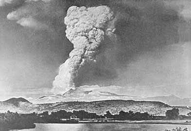
The last to form, and the highest cone, the Hotlum Cone, formed about 8,000 years ago. It is named after the Hotlum glacier on its northern face; its longest lava flow, the 500 feet (150 m) thick Military Pass flow, extends 5.5 miles (8.9 km) down its northwest face. Since the creation of the Hotlum Cone, a dacite dome intruded the cone and now forms the summit. The rock at the 600 feet (180 m) wide summit crater has been extensively hydrothermally altered by sulfurous hot springs and fumaroles there (only a few examples still remain). In the last 8,000 years, the Hotlum Cone has erupted at least eight or nine times. About 200 years ago the last significant Shasta eruption came from this cone and created a pyroclastic flow, a hot lahar (mudflow), and three cold lahars, which streamed 7.5 miles (12.1 km) down Shasta's east flank via Ash Creek. A separate hot lahar went 12 miles (19 km) down Mud Creek. This eruption was observed by the explorer La Pérouse, from his ship off the California coast, in 1786.[3]

During the last 10,000 years Shasta has erupted an average of every 800 years but in the past 4,500 years the volcano has erupted an average of every 600 years. The last significant eruption on Shasta may have occurred 200 years ago, as noted above. Mount Shasta can release volcanic ash, pyroclastic flows or dacite and andesite lava. Its deposits can be detected under nearby small towns totaling 20,000 in population. Shasta has an explosive, eruptive history. There are fumaroles on the mountain, which show that Shasta is still alive. The worst case scenario for an eruption is a large pyroclastic flow, such as what occurred in the 1980 eruption of Mount St. Helens. Since there is ice, such as Whitney Glacier and Mud Creek Glacier, lahars would also result. Ash would probably blow inland, perhaps as far as eastern Nevada. There is a small chance that an eruption could also be bigger resulting in a collapse of the mountain, as happened when Mount Mazama in Oregon collapsed to form what is now called Crater Lake, but this is of much lower probability. The United States Geological Survey considers Shasta a dormant volcano, which will erupt again. It is impossible to pinpoint the date of next eruption, but it likely will occur within the next several hundred years.

At the time of Euro-American contact in the 1820s, the Native American tribes who lived within view of Mount Shasta included the Shasta, Okwanuchu, Modoc, Achomawi, Atsugewi, Karuk, Klamath, Wintu, and Yana tribes. The lore of some of the American Indians in the area held that Shasta is inhabited by the spirit chief Skell who descended from heaven to the mountain's summit.

The historic eruption of Mount Shasta in 1786 may have been observed by la Perouse, but this is disputed. Although perhaps first seen by Spanish explorers, the first reliably-reported land sighting of Mount Shasta by a European or American was by Peter Skene Ogden (a leader of a Hudson's Bay Company trapping brigade) in 1826. Beginning in the 1820s, Mount Shasta was a prominent landmark along what became known as the Siskiyou Trail, which runs at Mount Shasta's base. The Siskiyou Trail was located on the track of an ancient trade and travel route of Native American footpaths between California's Central Valley and the Pacific Northwest. By the 1860s and 1870s, Shasta was the subject of scientific and literary interest. A book by California pioneer and entrepreneur James Hutchings, titled Scenes of Wonder and Curiosity in California, contained an account of an early summit trip in 1855.[12] The summit was achieved (or nearly achieved) by John Muir, Josiah Whitney, Clarence King, and John Wesley Powell. In 1877, Muir wrote a dramatic popular article about an experience in which he survived an overnight blizzard on Shasta by lying in the hot sulfur springs found near the summit.>>
Art Neuendorffer

User avatar
DavidLeodis
Perceptatron
Posts: 1169
Joined: Mon May 01, 2006 1:00 pm

Re: A Graceful Arc (2009 Dec 25)

Post by DavidLeodis » Sat Dec 26, 2009 6:10 pm

This and other similar images of the Milky Way are awe insipring. On a good night where I am I can see little more than the brightest stars. The scene does also look like it could be a Stargate to a wormhole! :)

rocksnstars
Ensign
Posts: 12
Joined: Sat Dec 26, 2009 7:51 pm

Re: A Graceful Arc (2009 Dec 25)

Post by rocksnstars » Sat Dec 26, 2009 7:58 pm

Beautiful! But to me confusing. It looks like Sgr is over Shasta, but Shasta is north of Lassen. Never mind. I reread, and it says "Earth and sky were made separately." Still beautiful, but not nearly exciting, realizing it was not something that could be actually seen.

User avatar
neufer
Vacationer at Tralfamadore
Posts: 18805
Joined: Mon Jan 21, 2008 1:57 pm
Location: Alexandria, Virginia

Re: A Graceful Arc (2009 Dec 25)

Post by neufer » Sat Dec 26, 2009 8:14 pm

http://earthobservatory.nasa.gov/IOTD/view.php?id=6240
http://en.wikipedia.org/wiki/Lassen_Peak wrote:
<<Before the arrival of white settlers, the areas surrounding Lassen Peak, especially in the east and south, were the traditional home of the northeastern Maidu. Lassen Peak was named in honor of Danish blacksmith Peter Lassen, who guided immigrants past the peak to Sacramento Valley in the 1830s. Lassen's trail, however, never found general long-term use because it was considered unsafe.

In 1864 Helen Tanner Brodt became the first woman to reach the summit of Lassen Peak. A tarn on Lassen was named Lake Helen in her honor.

On May 30, 1914 Lassen became active again after 27,000 years dormancy when it was shaken by a steam explosion. Such steam blasts occur when molten rock (magma) rises toward the surface of a volcano and heats shallow ground water. The hot water rises under pressure through cracks and, on nearing the surface, vaporizes and vents explosively. By mid-May 1915, more than 180 steam explosions had blasted out a 1,000-foot (300 m) wide crater near the summit of Lassen Peak.

Then the character of the eruption changed dramatically. On the evening of May 14, 1915, incandescent blocks of lava could be seen bouncing down the flanks of Lassen from as far away as the town of Manton, California 20 miles (30 km) to the west.[5] By the next morning, a growing dome of dacite lava (lava containing 63 to 68% silica) had filled the volcano’s crater.

Late on the evening of May 19, 1915, a large steam explosion fragmented the dacite dome, creating a new crater at the summit of Lassen Peak. No new magma was ejected in this explosion, but glowing blocks of hot lava from the dome fell on the summit and snow-covered upper flanks of Mount Lassen. These falling blocks launched a half mile (800 m) wide avalanche of snow and volcanic rock that roared 4 mi (6 km) down the volcano’s steep northeast flank and over a low ridge at Emigrant Pass into Hat Creek. As the hot lava blocks broke into smaller fragments, the snow melted, generating a mudflow of volcanic materials, called a lahar. The bulk of this lahar was deflected northwestward at Emigrant Pass and flowed 7 miles (11 km) down Lost Creek. Even after coming to rest, both the avalanche and lahar released huge volumes of water, flooding the lower Hat Creek Valley during the early morning hours of May 20. The lahar and flood destroyed six mostly not-yet-occupied summer ranch houses. Fortunately, the few people in these houses escaped with only minor injuries. Also during the night of May 19–20, dacite lava somewhat more fluid than that which erupted on the night of May 14–15 welled up into and filled the new crater at Lassen’s summit, spilled over low spots on its rim, and flowed 1,000 feet (300 m) down the steep west and northeast flanks of the volcano.

Image

Then at 4:30 p.m. on May 22, after two quiet days, Lassen exploded in a powerful eruption (referred to as "the Great Explosion") that blasted volcanic ash, rock fragments and pumice high into the air. This created the larger and deeper of the two craters seen near the summit of the volcano today. A huge column of volcanic ash and gas rose more than 30,000 feet (9,100 m) into the air and was visible from as far away as Eureka, California, 150 miles (240 km) to the west.

Pumice falling onto the northeastern slope of Lassen Peak generated a high-speed avalanche of hot ash, pumice, rock fragments, and gas, called a pyroclastic flow, that swept down the side of the volcano, devastating a 3 square miles (8 km2) area. The pyroclastic flow rapidly incorporated and melted snow in its path. The water from the melted snow transformed the flow into a highly fluid lahar that followed the path of the May 19–20 lahar and rushed nearly 10 miles (16 km) down Lost Creek to Old Station. This new lahar released a large volume of water that flooded lower Hat Creek Valley a second time.

The powerful climactic eruption of May 22 also swept away the northeast lobe of the lava flow extruded two days earlier. The eruption produced smaller mudflows on all flanks of Lassen Peak, deposited a layer of volcanic ash and pumice traceable for 25 miles (40 km) to the northeast, and rained fine ash at least as far away as Winnemucca, Nevada, 200 miles (320 km) to the east. Together these events created the Devastated Area which is still sparsely populated by trees due to the low nutrient and high porosity of the soil.>>
Art Neuendorffer

User avatar
geckzilla
Ocular Digitator
Posts: 9180
Joined: Wed Sep 12, 2007 12:42 pm
Location: Modesto, CA
Contact:

Re: A Graceful Arc (2009 Dec 25)

Post by geckzilla » Sat Dec 26, 2009 9:05 pm

rocksnstars wrote: it says "Earth and sky were made separately."
I really have to stop skimming over things so quickly. Somehow I missed this part of the description entirely. Now I realize my first post was redundant. Oops.
Just call me "geck" because "zilla" is like a last name.

rocksnstars
Ensign
Posts: 12
Joined: Sat Dec 26, 2009 7:51 pm

Re: A Graceful Arc (2009 Dec 25)

Post by rocksnstars » Sat Dec 26, 2009 11:38 pm

I spent some time in the area in the 90's, but yesterday when first seeing the photo I had forgotten that Shasta is north of Lassen. And not knowing exactly where the photo was taken, I thought maybe Shasta was south and the photographer was to the west of the mountains, looking east. That resulted in an impression of the photo being more or less an actual view, and the little phrase "exposures tracking Earth and sky were made separately" didn't mean much. (Still wouldn't if I hadn't done some checking.) Since most people will not have checked into the details, or skimmed the phrase, how many know that the photo is basically a fake? (That is what I call them.) Yes, it is beautiful, but if an APOD photo is something along those lines, maybe a somewhat more detailed explanation should be in the description . Or maybe I'm just a little too much into the truth, the whole truth, and nothing but the truth?

User avatar
BMAONE23
Commentator Model 1.23
Posts: 4076
Joined: Wed Feb 23, 2005 6:55 pm
Location: California

Re: A Graceful Arc (2009 Dec 25)

Post by BMAONE23 » Sun Dec 27, 2009 9:43 am

Looking at this map of shasta area I would say that the image was taken from somewhere southeast of Shasta from a fairly elevated position Like the top of Black Fox Mountain or farther east. This would allow for the Galactic center to be in the west (setting in the early evenng of late autumn) The view of shasta must be from the east because this is the only view that doesn't allow for the inclusion of shastina in the image. This also properly orients the Shasts/Lassen alignment in the image. I think the arc of the MW is properly aligned with the mountains in the image as viewed from the east.

rocksnstars
Ensign
Posts: 12
Joined: Sat Dec 26, 2009 7:51 pm

Re: A Graceful Arc (2009 Dec 25)

Post by rocksnstars » Sun Dec 27, 2009 1:53 pm

According to the photographer's website, the photos were taken at the Golden State Star Party this year, which was held late June near Adin CA. Adin is about 60 miles east and 10 miles south of Shasta. For Sgr to be over Shasta, Sgr would have to set north of due west. As you know, Sgr sets in the southwest, for us, since it is south of the celestial equator. I think the Milky Way was taken facing more or less east and was then pasted over the top of the land photo, which was taken facing west. This would "flip" the southern part of the Milky Way to the north. The first comment by geckzilla, about the horizon, is another clue.

User avatar
Chris Peterson
Abominable Snowman
Posts: 18190
Joined: Wed Jan 31, 2007 11:13 pm
Location: Guffey, Colorado, USA
Contact:

Re: A Graceful Arc (2009 Dec 25)

Post by Chris Peterson » Sun Dec 27, 2009 2:27 pm

BMAONE23 wrote:Looking at this map of shasta area I would say that the image was taken from somewhere southeast of Shasta from a fairly elevated position Like the top of Black Fox Mountain or farther east. This would allow for the Galactic center to be in the west (setting in the early evenng of late autumn) The view of shasta must be from the east because this is the only view that doesn't allow for the inclusion of shastina in the image. This also properly orients the Shasts/Lassen alignment in the image. I think the arc of the MW is properly aligned with the mountains in the image as viewed from the east.
I played around with a map and star chart for about a half hour, and it appears there's no place where you could ever see this image in reality. Any viewpoint that has the southern Milky Way over Shasta places the northern Milky Way substantially to the north, making it nowhere near Lassen.

It seems the image was entirely fabricated for aesthetic purposes- something that isn't really made clear in the caption. Personally, I don't think it should be an APOD at all. In fact, I consider this kind of extreme Photoshopping to be ethically dubious, since it misrepresents reality in a way that could easily lead to confusion (quite different from, say, a fantastic piece of space art). The evidence of that misrepresentation is right here in this forum: a handful of people with a good understanding of astronomy, geography, and imaging had to spend a fair bit of time analyzing the image in order to figure out that it doesn't even approximate a realistic scene.
Chris

*****************************************
Chris L Peterson
Cloudbait Observatory
https://www.cloudbait.com

rocksnstars
Ensign
Posts: 12
Joined: Sat Dec 26, 2009 7:51 pm

Re: A Graceful Arc (2009 Dec 25)

Post by rocksnstars » Sun Dec 27, 2009 7:47 pm

Amen! Thank you Chris!
tom hoffelder

tonyhallas
Asternaut
Posts: 1
Joined: Sun Dec 27, 2009 9:09 pm

Re: A Graceful Arc (2009 Dec 25)

Post by tonyhallas » Sun Dec 27, 2009 9:43 pm

Hello group,

I have to agree with some of you that someone using this image to plot their way by the stars has had it ... isn't going to happen. This image started as a trip to the Fall River Golf Course ... we discovered this overlook from which you could see Mt. Lassen all the way to Mt. Shasta. In my mind I saw it at night with the Milky Way going from volcano to volcano ... OBVIOUSLY impossible since the volcanoes run N- S. But visually ... wow ... I have to tell you all that this image touched the hearts of millions of people on Christmas Day ... I had many, many compliments ... more than any other image I have ever done.

But this raises an issue with which I have been doing battle for some time ... and that is the issue of the "authentic" image. What is this? We already know that most people loved this image ... but to some, knowing the alignment of everything ... it had no value because it was a "fake". Vision counts for nothing, art counts for nothing, emotional impact counts for nothing ... the image is not allowed by the "authenticity police" ... oh poor world!

By this definition, every narrow band image, every CCD image, every DSLR image, every negative scanned to digital image ... even the images of Ansel Adams ( a superb lab technician) are fakes. Why? Because the images have been modified. The minute you touch those pixels, or burn and dodge like Adams did, the image is modified. Do you want to discuss where to draw the line? Should there be an "authenticity congress" complete with lobbyists to set standards?

Art doesn't work this way ...

In this case, I would have had no problem mentioning that the Milky Way was taken seperately the night before and strategically positioned over the volcanoes ... it doesn't detract from the vision of the image. Whether or not "astronomical art" can be used as an APOD is left to the discretion of the hosts who are artists in their own right.

Hope you all have a great and creative 2010,

Clear skies,

Tony

User avatar
geckzilla
Ocular Digitator
Posts: 9180
Joined: Wed Sep 12, 2007 12:42 pm
Location: Modesto, CA
Contact:

Re: A Graceful Arc (2009 Dec 25)

Post by geckzilla » Sun Dec 27, 2009 10:04 pm

I don't think "fake" is the right word, Tony. "Confusing" or even "unintentionally deceptive" would be more appropriate. Your emotional appeals about touching the hearts of millions of people on Christmas Day don't change the fact that it managed to confuse us. As an artist myself I know we have to take criticism from all angles. Sometimes it helps you to become better at what you do and sometimes it's meaningless insults. I hardly think anyone here intended to insult you, so don't take it so personally.
Just call me "geck" because "zilla" is like a last name.

rocksnstars
Ensign
Posts: 12
Joined: Sat Dec 26, 2009 7:51 pm

Re: A Graceful Arc (2009 Dec 25)

Post by rocksnstars » Sun Dec 27, 2009 11:00 pm

I really want to know 1) did the APOD people know the whole story, and 2) if not, why not? If they did, and published it with no explanation, we all need to recalibrate our concept of what we expect here. I guess I mean people like Chris and I do...

User avatar
Chris Peterson
Abominable Snowman
Posts: 18190
Joined: Wed Jan 31, 2007 11:13 pm
Location: Guffey, Colorado, USA
Contact:

Re: A Graceful Arc (2009 Dec 25)

Post by Chris Peterson » Mon Dec 28, 2009 12:28 am

tonyhallas wrote:By this definition, every narrow band image, every CCD image, every DSLR image, every negative scanned to digital image ... even the images of Ansel Adams ( a superb lab technician) are fakes. Why? Because the images have been modified. The minute you touch those pixels, or burn and dodge like Adams did, the image is modified. Do you want to discuss where to draw the line?
I disagree with the use of "fake" in this context. Simply modifying an image isn't enough. It's a question of intent. Where the intent is journalistic or scientific, these lines have been largely defined. Narrow band images don't look like what the eye sees, but they are an accurate reflection of reality. Images that have had their contrast stretched still reflect reality. But images that have been structurally modified do not (remember the flack that National Geographic took when they digitally shifted the position of one of the Pyramids to make an image fit their cover? That's one of the incidents that helped define what is and is not okay.) Now there's nothing wrong with structural modification, as long as the intent is purely artistic. My only complaint here is that the content was presented in a way that made it seem like a realistic image- something that could actually be seen, but for the sensitivity of the eye. APOD sometimes presents artistic impressions, or even outright fantasy. That's fine, as long as there is no possibility for confusion. As a site that primarily presents material of high scientific quality, it is important to avoid the possibility of misunderstanding.
Chris

*****************************************
Chris L Peterson
Cloudbait Observatory
https://www.cloudbait.com

rocksnstars
Ensign
Posts: 12
Joined: Sat Dec 26, 2009 7:51 pm

Re: A Graceful Arc (2009 Dec 25)

Post by rocksnstars » Mon Dec 28, 2009 2:05 am

Changing the subject somewhat, the sky portion of the photo could have been "flipped" to put Sgr in the southwest, over Lassen. It still would not have been reality, since the Milky Way would then be curving up over the photographer if that is where Sgr actually was, but it would probably have made it less likely to be decoded, since the most prominent sky feature would at least be where it could be. The "mirror image" would not likely have been noticeable.

Lazlo Nibble
Asternaut
Posts: 2
Joined: Mon Apr 13, 2009 5:06 pm

Re: A Graceful Arc (2009 Dec 25)

Post by Lazlo Nibble » Mon Dec 28, 2009 6:24 pm

I'll give Tony and APOD credit here, at least they were honest (if vague) about the creation process in the description and in Tony's response here -- unlike with True Image from False Kiva. That case is far worse because of the repeated claims to the contrary, from the implication in the "title" of the image through the ensuing discussion here. (In brief: The shadows on the bluffs could only have been created by light from the horizon shortly after sunset; despite Pacholka's claims in the discussion thread, the moon was in the wrong part of the sky at the time. But the sun set several hours before the Milky Way reached the depicted position in the sky -- indicating that the sky and landscape could not have been photographed at the same time.)

In a journalistic context, images manipulated like this have to be explicitly labeled as "photoillustrations", and in my opinion the same should be true on APOD. We're not talking about dodging and burning here -- we're talking about creating an image of something that didn't actually happen (and in this particular case, couldn't happen). Failure to disclose when this is done isn't just bad because it's dishonest, it's bad because it makes people (justifiably) skeptical of other spectacular photos that were created without that kind of trickery, which in turn degrades the impact and value of that kind of work.

User avatar
bystander
Apathetic Retiree
Posts: 21577
Joined: Mon Aug 28, 2006 2:06 pm
Location: Oklahoma

Re: A Graceful Arc (2009 Dec 25)

Post by bystander » Mon Dec 28, 2009 7:11 pm

Lazlo Nibble wrote:... unlike with True Image from False Kiva. That case is far worse because of the repeated claims to the contrary, from the implication in the "title" of the image through the ensuing discussion here. (In brief: The shadows on the bluffs could only have been created by light from the horizon shortly after sunset; despite Pacholka's claims in the discussion thread, the moon was in the wrong part of the sky at the time. But the sun set several hours before the Milky Way reached the depicted position in the sky -- indicating that the sky and landscape could not have been photographed at the same time.)
Yes, obviously, you know so much more about the conditions under which the photographs were made than the photographer. And, obviously, Mr. Pacholka is so unsuccessful that he needs to lie about how he photgraphed a particular scene. And NASA, TWAN. NPS, et al, are so gullible that they just assume that everything is authentic.

(37 APODs, 92 TWAN, and numerous national publications) (what were your credentials, again) :roll:

User avatar
geckzilla
Ocular Digitator
Posts: 9180
Joined: Wed Sep 12, 2007 12:42 pm
Location: Modesto, CA
Contact:

Re: A Graceful Arc (2009 Dec 25)

Post by geckzilla » Mon Dec 28, 2009 7:55 pm

Well, he really does hire out a lab to stitch his photos together for him. Don't I feel stupid for making assumptions in an earlier thread, now. Who knows what that lab did to the photo but they definitely don't have a strong knowledge of how the atmosphere works. That cave pic is just plain wrong looking regardless of how "real" it is.

And now I know why he never responded to my email about that geminid photo, either... :(
Just call me "geck" because "zilla" is like a last name.

User avatar
Case
Commander
Posts: 616
Joined: Sat Jun 09, 2007 10:08 pm
Location: (52°N, 06°E)

Re: A Graceful Arc (2009 Dec 25)

Post by Case » Mon Dec 28, 2009 9:16 pm

Every photo with point-like stars and some distant earthbound foreground without motion blur is a montage of earth and sky.
The only exception that I know of is the APOD of 13 March 2004.
I, for one, like Roman numerals.

Lazlo Nibble
Asternaut
Posts: 2
Joined: Mon Apr 13, 2009 5:06 pm

Re: A Graceful Arc (2009 Dec 25)

Post by Lazlo Nibble » Mon Dec 28, 2009 9:30 pm

bystander wrote:(37 APODs, 92 TWAN, and numerous national publications) (what were your credentials, again) :roll:
I can walk through the analysis in detail if anyone cares enough to double-check the assumptions behind it. It's certainly possible I'm missing something.

rocksnstars
Ensign
Posts: 12
Joined: Sat Dec 26, 2009 7:51 pm

Re: A Graceful Arc (2009 Dec 25)

Post by rocksnstars » Tue Dec 29, 2009 12:39 am

I guess honesty has become a relative term. "..exposures tracking Earth and sky were made separately" is beyond vague to those of us who never expected to see a photo like this on APOD. I really can't believe they published it with only those words, knowing the whole story. Do they ever reply here?

tom hoffelder

User avatar
Chris Peterson
Abominable Snowman
Posts: 18190
Joined: Wed Jan 31, 2007 11:13 pm
Location: Guffey, Colorado, USA
Contact:

Re: A Graceful Arc (2009 Dec 25)

Post by Chris Peterson » Tue Dec 29, 2009 1:28 am

rocksnstars wrote:I guess honesty has become a relative term. "..exposures tracking Earth and sky were made separately" is beyond vague to those of us who never expected to see a photo like this on APOD. I really can't believe they published it with only those words, knowing the whole story. Do they ever reply here?
There's absolutely nothing wrong with using separate exposures and images for the sky and the Earth foreground. That's a reasonable (often only) way to combine the two without getting star trails. It's no different from a variety of other mosaic techniques, or images made from overlaying different data sets. The only thing that makes this image questionable for an APOD is that the region of sky imaged and the region of Earth imaged don't (and can't) line up in reality. So we end up with a fantasy image that is not readily identifiable as such.
Chris

*****************************************
Chris L Peterson
Cloudbait Observatory
https://www.cloudbait.com

rocksnstars
Ensign
Posts: 12
Joined: Sat Dec 26, 2009 7:51 pm

Re: A Graceful Arc (2009 Dec 25)

Post by rocksnstars » Tue Dec 29, 2009 3:33 am

Chris, I'm on your side. ("I don't think it should be on APOD at all.") I'm talking about the person who "gave credit" to APOD. I still don't think APOD people knew what the photo was. I think (and hope) that they would have said a little bit more in the description if they did know. If they did know, and that is all they said, then as I said, I need to recalibrate my expectations of what I see here! I have been looking at APOD nearly every day for as long as it has existed. Yes, there are all kind of photos that are "touched up" in all manners of acceptable ways, but this is the first one I've questioned. And, as implied earlier, that may be only because the photographer did not see a problem with having Sagittarius in the north.

Post Reply