by neufer » Tue Jan 08, 2013 3:47 am
Anthony Barreiro wrote:neufer wrote:Anthony Barreiro wrote:
That huge boulder in the middle of the central depression caught my eye the first time I saw this photo. I recall reading that the central depression is the size of a football stadium, so the boulder is truly monstrous. I hope LRO operates long enough for us to see what hatches from that cosmic egg.
I'm guessing there's a smaller roc inside.
And inside the smaller roc a littler roc, and so ad infinitum?
http://en.wikipedia.org/wiki/Bernard_de_la_Harpe wrote:
<<Jean-Baptiste Bénard de la Harpe (b. 4 Feb 1683, in Saint-Malo- d. 26 September 1765) was a French explorer who is credited with the discovery of Little Rock, Arkansas. He was the first known French explorer to set foot in the future state of Oklahoma.
In 1722, La Harpe ascended the Arkansas River and found two distinct rock formations on the Arkansas River, the smaller one the South bank he named La Petite Roche and the larger on the North bank La Grande Roche. He based a trading post near the smaller formation, as a Quapaw Indian settlement was stationed there. He explored the Arkansas River another 25 leagues (70 miles) above Little Rock.
[Three years before] La Harpe established a trading post in April 1719 on the Red River near what is now Texarkana, Texas. La Harpe followed the Red River upstream, probably to the vicinity of present day Idabel, Oklahoma.
He then turned north to cross the rugged east-west ridges of the Ouachita (WOSH-i-taw) Mountains which rise more than one thousand feet above the intervening valleys. On September 3, after 23 days of traveling, La Harpe and his party reached a large settlement; archaeological evidence points to it being located about 13 miles south of Tulsa, Oklahoma near the western bank of the Arkansas River. The presence of various Wichita tribes suggests that the village was a melting pot and probably a trade center for the entire region. The Wichita gave La Harpe a friendly reception, so friendly that two Black slaves in his group wanted to stay with the Indians rather than return with La Harpe. La Harpe noted that the Wichita had horses, were excellent farmers, and that game in the area was abundant. The Wichita told him they were cannibals. While in the Wichita village, a Chickasaw trader visited. This was disturbing to La Harpe as the Chickasaw, who lived in Mississippi, were allies of the British. La Harpe left to return to his starting point on Sept 13, 1719 and arrived on October 13. En route, an Indian man and woman traveling with him were killed by Apaches and La Harpe became lost in the mountains and had to eat his horses.>>
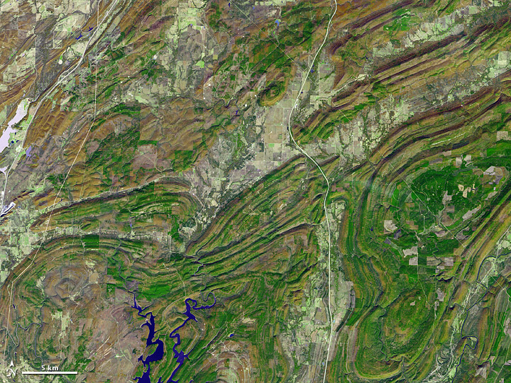
- [b][color=#0000FF]On November 13, 2002, the Advanced Spaceborne Thermal Emission and Reflection Radiometer (ASTER) on NASA’s Terra satellite captured this image. This picture combines infrared, red, and green wavelengths of light, and roughly approximates true color. The mountains are complex, nearly forming paisley patterns with their long, folding contours. Low-lying areas between the slopes accommodate water bodies, crops, towns, and roads. Pale-hued highways cut through the region, running primarily north-south.[/color][/b]
http://earthobservatory.nasa.gov/IOTD/view.php?id=46485 wrote:
<<
The Ouachita (WOSH-i-taw) Mountains record a complicated geologic history spanning hundreds of millions of years. Long before the first dinosaur evolved, what is now the southern central United States sat at the bottom of an ancient sea. From roughly 550 to 340 million years ago, the area collected sediments eroding off nearby continents, as well as detritus of sea life. Starting around 340 million years ago, a tectonic plate that had previously been attached to Africa and South America collided with the North American plate. The process helped form the supercontinent of Pangaea, and it thrust the ancient sea floor skyward. The similarities between rock layers of the Ouachita Mountains and the Appalachian Mountains indicate that they were part of a massive mountain chain formed by this collision. Once elevated, the mountains soon commenced eroding. About 200 million years ago, Pangaea began to break apart. The breakup wrenched apart the supersized mountain range, leaving a wide swath of low-lying land between the Ouachita Mountains in the west and the Appalachian Mountains in the east. Low-profile land persists today across much of the southeastern United States.>>
[quote="Anthony Barreiro"][quote="neufer"][quote="Anthony Barreiro"]
That huge boulder in the middle of the central depression caught my eye the first time I saw this photo. I recall reading that the central depression is the size of a football stadium, so the boulder is truly monstrous. I hope LRO operates long enough for us to see what hatches from that cosmic egg.[/quote]
I'm guessing there's a smaller roc inside.[/quote]
And inside the smaller roc a littler roc, and so ad infinitum?[/quote][quote=" http://en.wikipedia.org/wiki/Bernard_de_la_Harpe"]
<<Jean-Baptiste Bénard de la Harpe (b. 4 Feb 1683, in Saint-Malo- d. 26 September 1765) was a French explorer who is credited with the discovery of Little Rock, Arkansas. He was the first known French explorer to set foot in the future state of Oklahoma.
In 1722, La Harpe ascended the Arkansas River and found two distinct rock formations on the Arkansas River, the smaller one the South bank he named La Petite Roche and the larger on the North bank La Grande Roche. He based a trading post near the smaller formation, as a Quapaw Indian settlement was stationed there. He explored the Arkansas River another 25 leagues (70 miles) above Little Rock.
[Three years before] La Harpe established a trading post in April 1719 on the Red River near what is now Texarkana, Texas. La Harpe followed the Red River upstream, probably to the vicinity of present day Idabel, Oklahoma. [b][color=#0000FF]He then turned north to cross the rugged east-west ridges of the Ouachita (WOSH-i-taw) Mountains which rise more than one thousand feet above the intervening valleys.[/color][/b] On September 3, after 23 days of traveling, La Harpe and his party reached a large settlement; archaeological evidence points to it being located about 13 miles south of Tulsa, Oklahoma near the western bank of the Arkansas River. The presence of various Wichita tribes suggests that the village was a melting pot and probably a trade center for the entire region. The Wichita gave La Harpe a friendly reception, so friendly that two Black slaves in his group wanted to stay with the Indians rather than return with La Harpe. La Harpe noted that the Wichita had horses, were excellent farmers, and that game in the area was abundant. The Wichita told him they were cannibals. While in the Wichita village, a Chickasaw trader visited. This was disturbing to La Harpe as the Chickasaw, who lived in Mississippi, were allies of the British. La Harpe left to return to his starting point on Sept 13, 1719 and arrived on October 13. En route, an Indian man and woman traveling with him were killed by Apaches and La Harpe became lost in the mountains and had to eat his horses.>>[/quote][float=right][img3="[b][color=#0000FF]On November 13, 2002, the Advanced Spaceborne Thermal Emission and Reflection Radiometer (ASTER) on NASA’s Terra satellite captured this image. This picture combines infrared, red, and green wavelengths of light, and roughly approximates true color. The mountains are complex, nearly forming paisley patterns with their long, folding contours. Low-lying areas between the slopes accommodate water bodies, crops, towns, and roads. Pale-hued highways cut through the region, running primarily north-south.[/color][/b]"]http://eoimages.gsfc.nasa.gov/images/imagerecords/46000/46485/ouachita_ast_2002317.jpg[/img3][/float][quote=" http://earthobservatory.nasa.gov/IOTD/view.php?id=46485"]
<<[b][color=#0000FF]The Ouachita (WOSH-i-taw) Mountains record a complicated geologic history spanning hundreds of millions of years.[/color][/b] Long before the first dinosaur evolved, what is now the southern central United States sat at the bottom of an ancient sea. From roughly 550 to 340 million years ago, the area collected sediments eroding off nearby continents, as well as detritus of sea life. Starting around 340 million years ago, a tectonic plate that had previously been attached to Africa and South America collided with the North American plate. The process helped form the supercontinent of Pangaea, and it thrust the ancient sea floor skyward. The similarities between rock layers of the Ouachita Mountains and the Appalachian Mountains indicate that they were part of a massive mountain chain formed by this collision. Once elevated, the mountains soon commenced eroding. About 200 million years ago, Pangaea began to break apart. The breakup wrenched apart the supersized mountain range, leaving a wide swath of low-lying land between the Ouachita Mountains in the west and the Appalachian Mountains in the east. Low-profile land persists today across much of the southeastern United States.>>[/quote]