
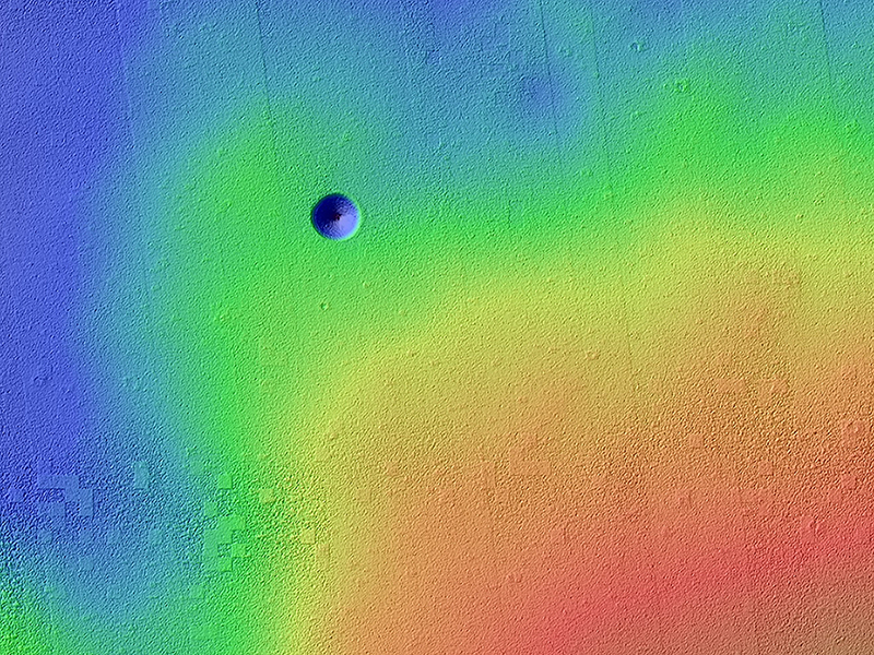
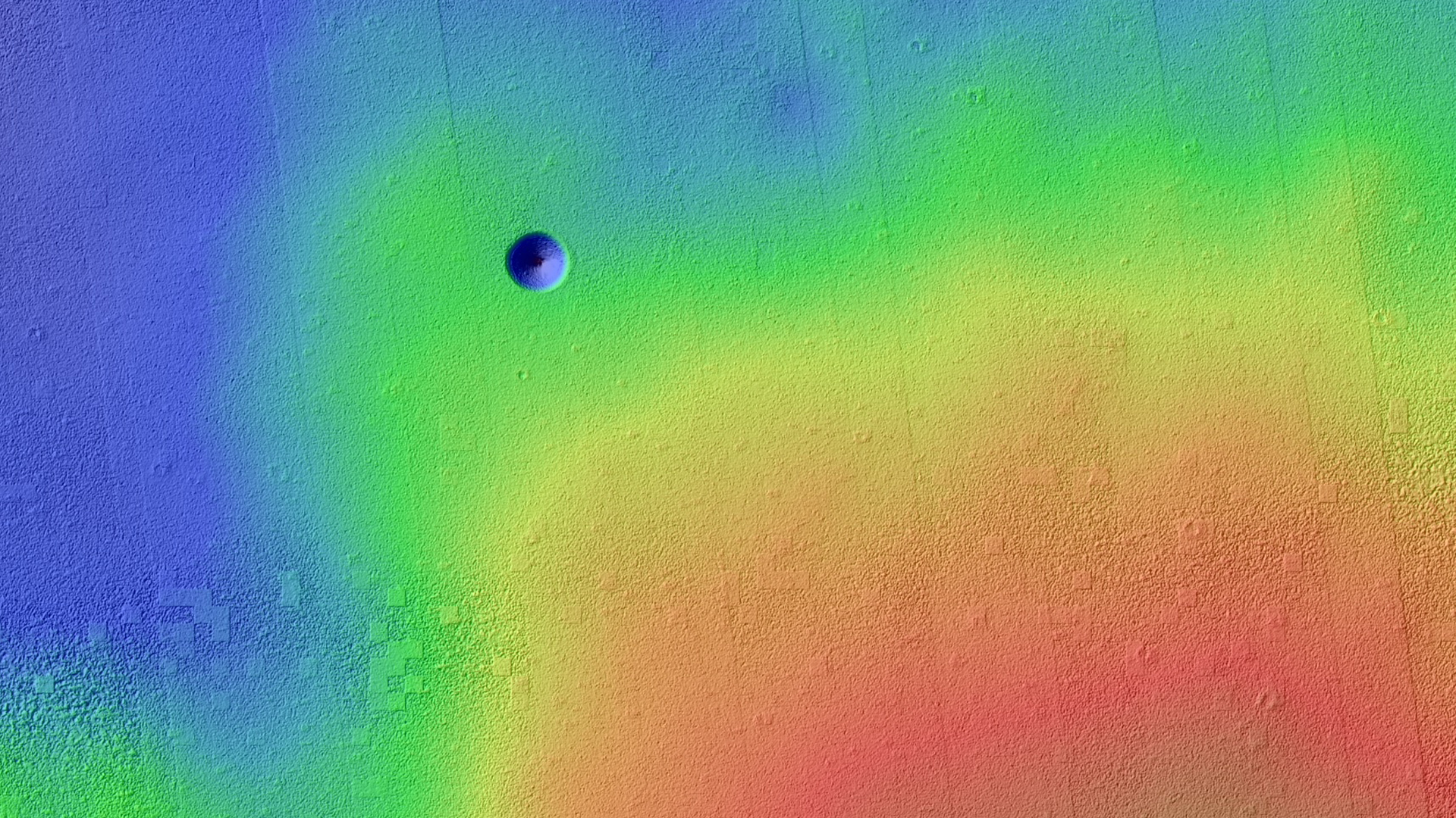
Shane Byrne wrote:A Giant Cave on a Giant Volcano (ESP_023531_1840) (HiClip)
avonis Mons is a giant shield volcano similar to (although larger than) those on the Big Island of Hawaii. These volcanoes are mostly made of stacks of overlapping lava flows. These images and digital terrain model (DTM) show a collapse feature on Pavonis Mons. The walls of this conical pit are steep (about as steep as it is possible to get before loose material rolls downhill). The material that used to be here has drained downward through the opening seen in the center into a subterranean void and formed a debris pile. The top of this debris pile can be seen through the opening about 28 meters (92 feet) further down.
From this DTM we can measure how much material drained out of the conical pit and so estimate how tall the debris pile is. These estimates are enormous: the debris pile itself is at least 62 meters (203 feet) tall. Given that the top of this pile is 28 meters below the rim of the central hole, this tells us that the empty cavity was once 90 meters (295 feet) deep, prior to the collapse and infilling! Only a handful of caves on the Earth reach or exceed this size and they all formed by having liquid water dissolve underground limestone, neither of which are readily available on Mars.
Sometimes the tops of lava flows freeze on the surface even while the lava continues to move underground in a lava tube. If these tubes drain, then lava tube caves can be left behind. Sections of the roof may later collapse, creating roof openings, and these openings can be imaged from orbit. Could this be a view into a lava tube? If so, it would dwarf all lava tubes on the Earth! It's also possible that this collapse is above some more substantial part of the volcano's internal plumbing system and collapses deep with the mountain are allowing voids to open up near the surface. It would no doubt be very exciting for future astronauts to explore this mammoth cave and figure out its origin.
View the DTM details page for this observation.
This is a stereo pair with ESP_023953_1840.
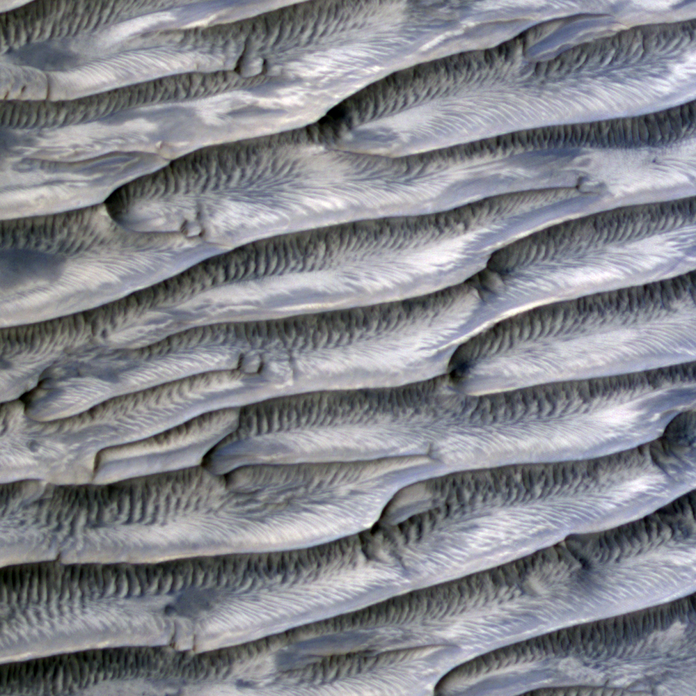
Colin Dundas wrote:Feathery Ridges (ESP_036485_1765) (HiClip)
This HiRISE image shows a valley filled with an assortment of linear ridges. These ridges are often referred to as transverse aeolian ridges, or TAR, and they take a variety of forms. Here they sit at right angles to the direction of the valley, because the topography funnels the wind along the trough.
At this location, some of the TAR have secondary structures, likely small ripples. It is common for sand dunes to be covered in small ripples, often with different orientations that may be shaped by winds redirected by the larger dunes. Here the secondary structures have an unusual radiating/converging pattern, giving the TAR here a feathery appearance.

HiRISE Science Team wrote:A Revealing Landslide in Hebes Chasma (ESP_036927_1790) (HiClip)
This image shows a prominently stratified transect through the rock of a mountain of material in the middle of Hebes Chasma.
The knobby material showing several lineations in the center of the scene may be remnants of landslides that exposed these tall, steep slopes in this image and just off-scene to the west. Mid-way up the slope (and to a lesser extent all the way up to the top) a series of alternating lighter and darker bands can be traced running east-west across the ridges and troughs of the outcrop. Just below this, dark material is eroding off of the slope, moving downhill, and collecting in fans at the base of the cliff.
Exposures of layered rock like these are helpful in determining the types of geologic processes that have occurred at an area over time, and the landslide and fan deposits tell of how the region is being eroded more recently, including today.
This observation was the winning entry by Jon Green for the BBC's Sky at Night program, where viewers were challenged to submit a potential target for HiRISE to image, using our public HiWish program.
Alfred McEwen wrote:An Impact Crater in Isidis Planitia (ESP_036934_1915) (HiClip)
This recent observation is the fifth time we’ve imaged this spot on Mars. We often re-image spots on the surface to search for, or track changes, due to active processes, such as migrating sand dunes.
In this case, there isn’t any known activity, although careful comparison of the images could show changes. Instead, we acquired these pictures at a range of viewing and illumination angles as an experiment to try to extract new information at the limits of image resolution. This is possible in two ways: by seeing the 3D shapes from different illumination and viewing angles, and, after orthorectification of the images, by combining them into a “super-resolution” image. (Orthorectification shows how the sloping surface appears from directly overhead).
This location is also the site of an early candidate for location of the Beagle 2 lander based on an image from the Mars Global Surveyor. HiRISE has acquired 24 other images covering most of the expected Beagle-2 landing ellipse, but no clear evidence for Beagle 2 has been reported.
Credit: NASA/JPL/University of Arizona
<< Previous HiRISE Update