
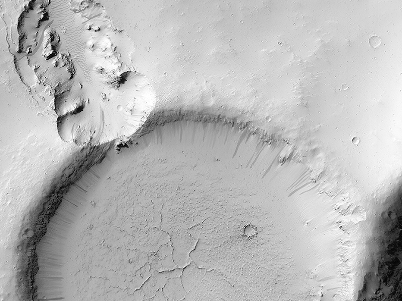
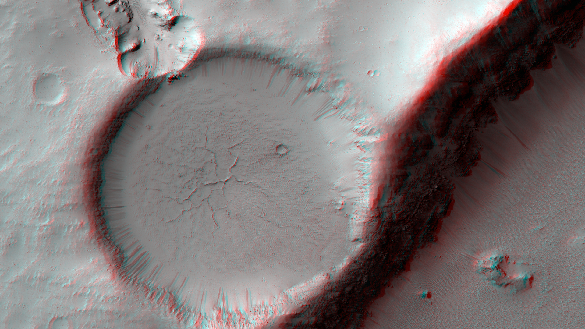
HiRISE Targeting Specialists wrote:Which Way is Up? (ESP_035969_1825) (HiClip)
This image shows an impact crater that was cut by lava in the Elysium Planitia region of Mars. The relatively flat, shallow floor, rough surface texture, and possible cooling cracks seem to indicate that the crater was partially filled with lava. The northern part of the image also shows a more extensive lava flow deposit that surrounds the impact ejecta of the largest impact crater in the image.
Which way did the lava flow? It might appear that the lava flowed from the north through the channel into the partially filled crater. However, if you look at the anaglyph with your red and blue 3D glasses, it becomes clear that the partially filled crater sits on top of the large crater's ejecta blanket, making it higher than the lava flow to the north. Since lava does not flow uphill, that means the explanation isn't so simple.
We have seen much evidence for lava flows in this region that flowed to much higher levels than the present surface, then deflated or drained away. That may have happened here: lava flowed from from north to south to fill this crater, but then it drained back to the north, carving this channel.
The topographic information that we gained from having a stereo pair let us answer a question that we could not have with only a single image. This is a great example of why we take stereo images, where the two images are used to make a 3D image.
This is a stereo pair with ESP_025631_1825.
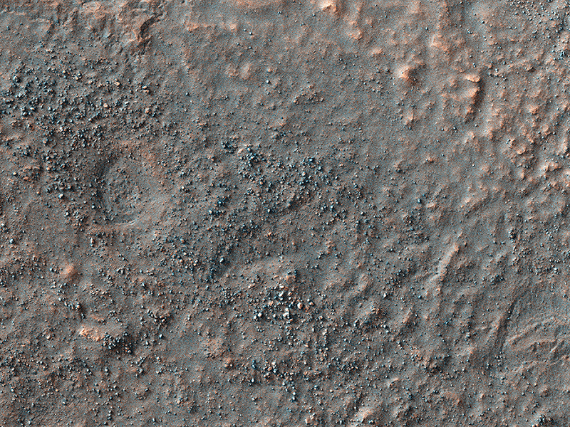
HiRISE Science Team wrote:Search for the Mars 2 Debris Field (ESP_037371_1350) (HiClip)
Despite the recent successes of missions landing on Mars, like the Mars Science Laboratory (Curiosity) or the arrival of new satellites, such as India's MOM orbiter, the Red Planet is also a graveyard of failed missions.
The Soviet Mars 2 lander was the first man-made object to touch the surface of the Red Planet when it crashed landed on 27 November 1971. It is believed that the descent stage malfunctioned after the lander entered the atmosphere at too steep an angle. Attempts to contact the probe after the crash were unsuccessful.
HiRISE acquired this image to aid in the search for the missing lander. If the Mars 2 debris field is found it could serve as a future landing location for a mission to study the effects of crash landing on the Martian surface and effects of aging on man-made objects.
This caption is based on the original science rationale. To date, the debris field has not been located, but this spot was noted as a probably location for the Mars 3 lander.
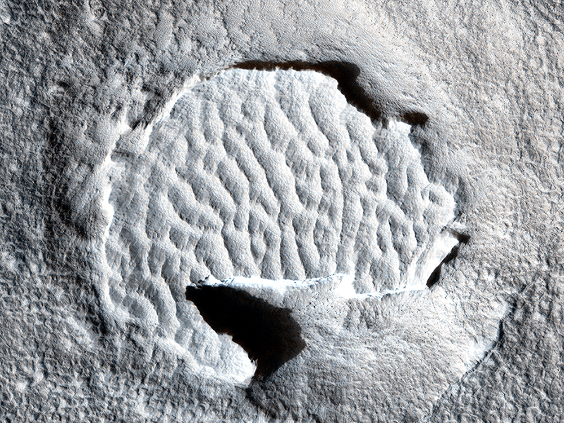
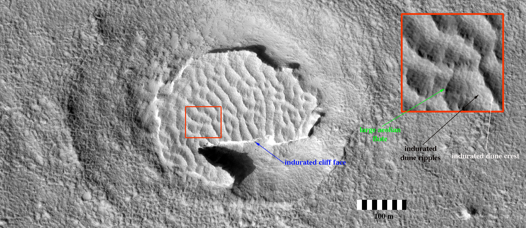
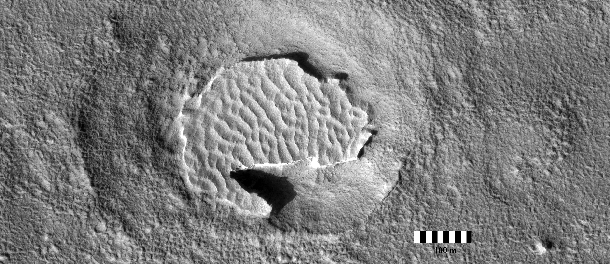
Nathan Bridges wrote:Hardened Dunes in Arcadia Planitia (ESP_038143_2205) (HiClip)
HiRISE, with its high resolution and 8 years in orbit about Mars, has shown that many dunes and ripples on the planet are active. This demonstrates that in some areas sand is loose enough and winds strong enough, that significant change can occur.
Nevertheless, other Martian dunes are clearly *inactive*. This image in Arcadia Planitia shows dunes in a crater. Unlike active dunes on the planet, those here are bright, and, zooming in, there are several lines of evidence indicating that the dunes have become indurated, that is, hardened into cohesive sediment or even into sandstone rock. For example, the dune field at the southern edge is cut off by a step cliff, indicating erosion of hard material. Although fine scale ripples on the original dune surface are preserved, we also see large scale fluting from southwest to northeast, a common texture associated with wind-induced sand abrasion.
How these dunes became indurated is unknown. One possibility is that this area of Mars was buried and then exhumed, a process that seems to have occurred many times in the Martian past over various areas of the planet. During burial, compaction and possibly ground water circulation would have indurated the dunes, leaving them as a hard sandstone that, when exhumed, was subsequently partially eroded.
Note: a version of the cutout is with only the scale bar is here.
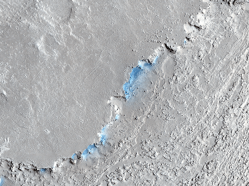
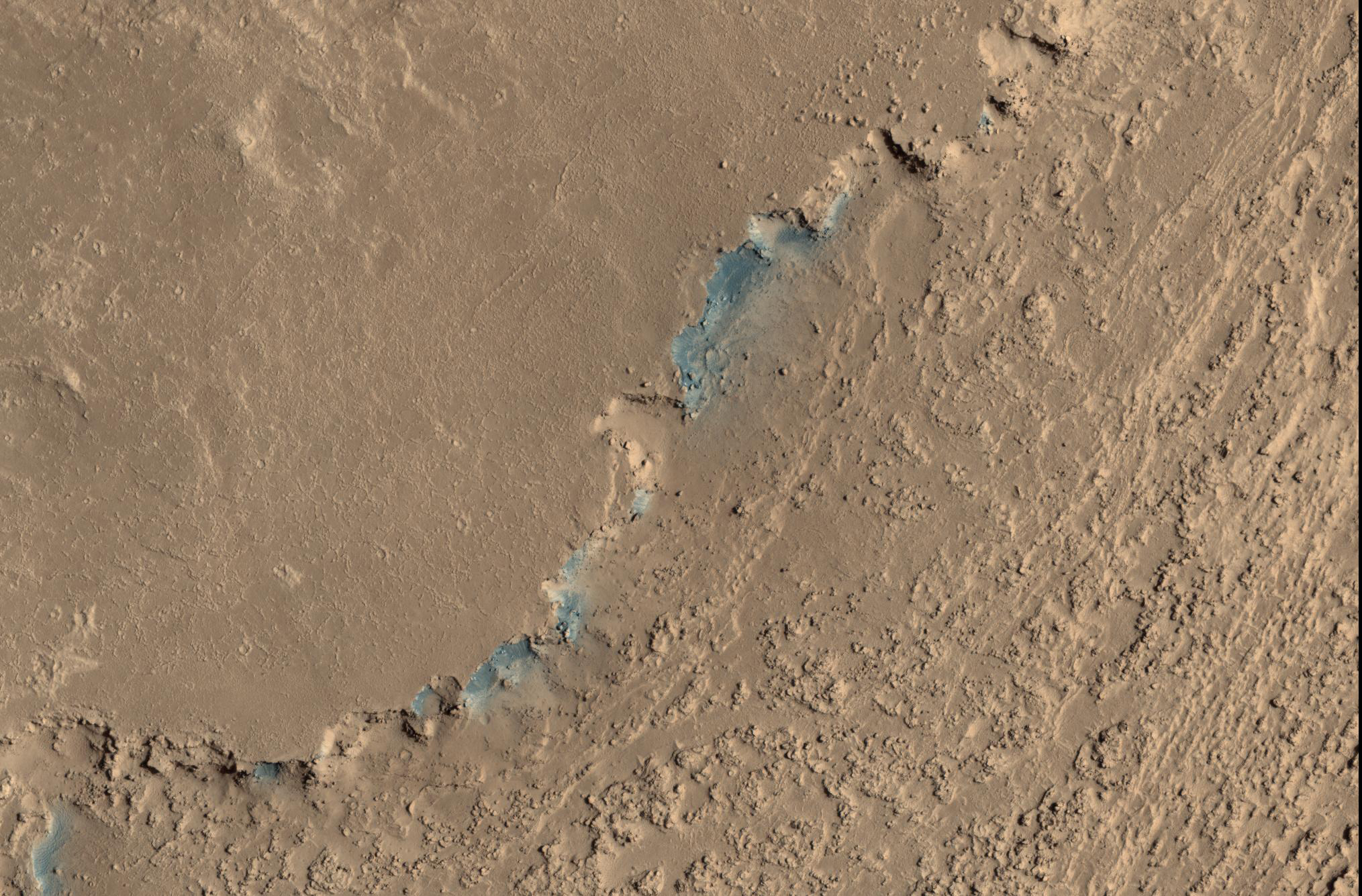
Paul Geissler wrote:Sand Sources Near Athabasca Valles (ESP_038224_1890) (HiClip)
This image shows a small channel cutting into young volcanic lavas in a region where massive catastrophic flooding took place in the relatively recent past. The Athabasca Valles region includes a vast lava flow, thought to be the youngest on Mars, with even younger outflow channels that were carved by running water. The source of the water is believed to be the Cerberus Fossae valleys to the north, which may have penetrated to an over-pressurized aquifer in the subsurface.
Nowadays, erosion by gravity, wind, and frost gradually wears down the rims of the outflow channels. In this scene, we see dark materials along the channel rim that were probably exposed by this erosion. The dark materials are less red than the surrounding surface and so they appear blue in this enhanced color picture. Viewed close up, the dark materials show ripples that suggest they are made up of mobile sand. It is possible that this sand originated elsewhere and simply collected where we see it today, but the fact that sand is not found elsewhere in the scene suggest to us that it is eroding out of the volcanic layers at the retreating rim of the channel.
Sand sources are important because mobile sand grains have only a limited lifetime, wearing down and chipping apart each time they impact the surface. Erosion of the volcanic materials in this region may provide sands to replace those that are destroyed. Few such sand sources have so far been identified on Mars.
Credit: NASA/JPL/University of Arizona
<< Previous HiRISE Update