
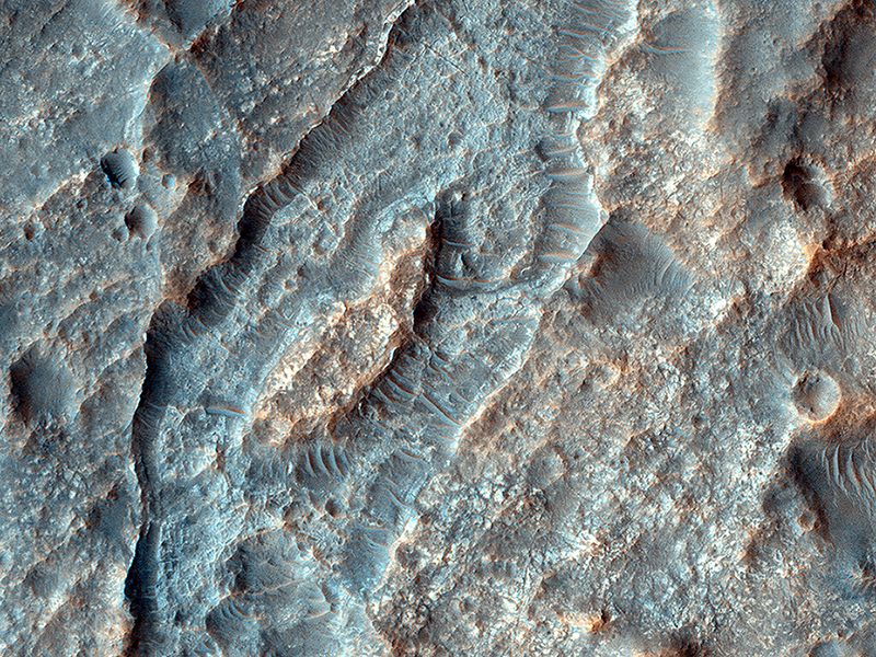
Cathy Weitz wrote:Inverted Ridges in the Eridania Basin (ESP_038949_1485) (HiClip)
This closeup of a HiRISE image covers a region in the Eridania Basin that shows interesting inverted ridges (white arrows).
The ridges display a dendritic, or branched, pattern and may have once been connected to a larger channel (black arrows). One possible way these ridges formed is when smaller valleys filled in with sediments. These sediments became cemented and lithified which made them stronger than their surroundings.
Over time, erosion removed the surrounding terrain but the lithified sediments in the valleys are stronger so they have remained and now appear higher (or inverted) than their surroundings.
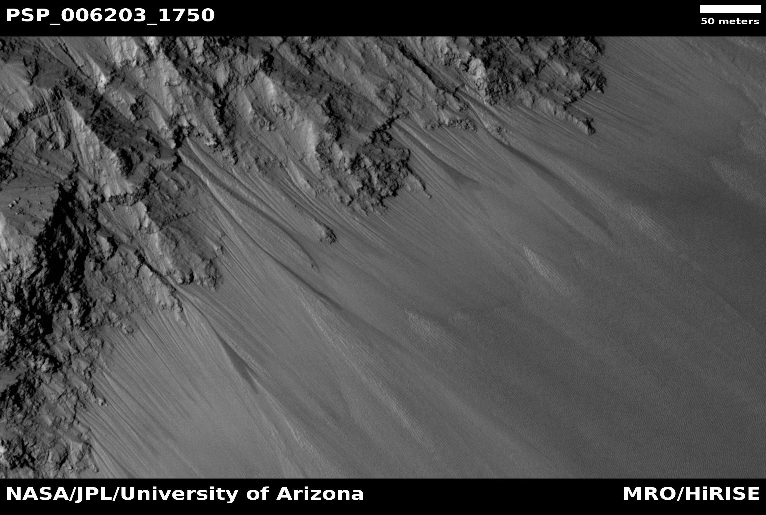
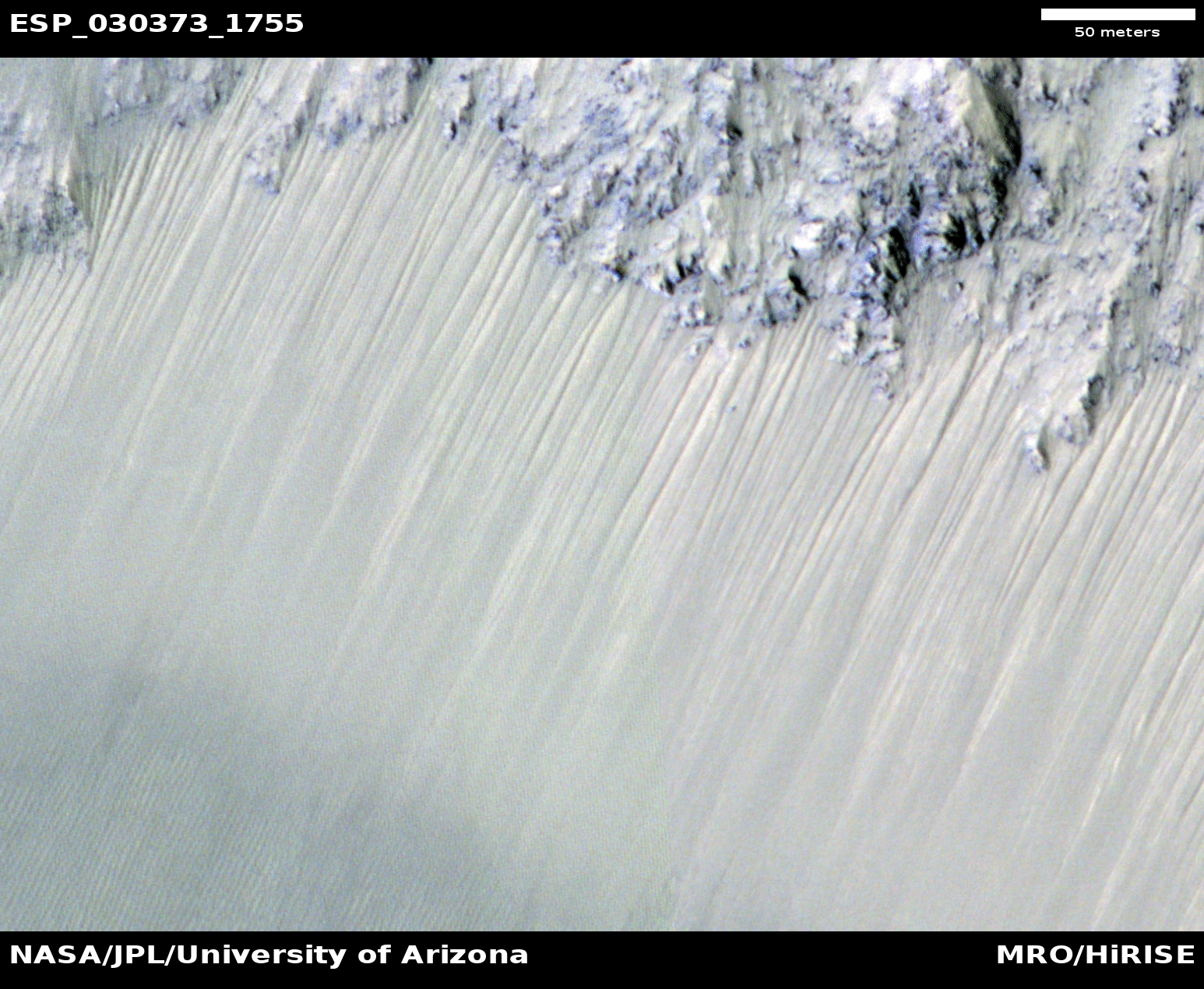
Alfred McEwen wrote:Recurring Slope Lineae in Juventae Chasma (ESP_030373_1755) (HiClip)
Recurring slope lineae (RSL) are best explained as due to seasonal seeping of water on steep slopes in warm seasons. The HiRISE team has produced digital terrain models (DTMs) for many key RSL sites, which then allows us to orthorectify the images, correcting the geometry to the view from straight overhead. A series of images over a site are then precisely registered and can be compared to study changes over time.
Juventae Chasma is a giant box canyon, yet a relatively small segment of the enormous Valles Marineris system. It is breached to the north, leading to the Maja Vallis outflow channel. The box canyon may have been nearly filled with water long ago (a couple billion years), but was released catastrophically when the region north of the box canyon collapsed. That was long ago, and the water in Juventae Chasma today forming the RSL is a very tiny amount, whose origin remains a mystery. Maybe the water is replenished each year from the atmosphere or from deeper water or ice.
The RSL are active on the north-facing slopes of these hills when the subsolar point is north of this latitude, and they are active on south-facing slopes when the sun is to the south. However, they are not continuously active, and exactly what controls the timing of activity is not yet known.

Ginny Gulick wrote:Frosted Gullies in a Central Pit (ESP_038903_1115) (HiClip)
The frosted gullies in this observation are located along an irregularly shaped pit approximately 15 kilometers wide. The pit lies within an impact crater in Sisyphi Planum that is about 35 kilometers in diameter and is located northwards of the Southern polar layered deposits.
Carbon dioxide frost covers much of the region and helps to reveal subtle textures in the landscape. The layered sediment visible in the walls of the pit and in which these gullies formed likely originally filled much of the impact crater.
Evidence for a variety of processes abound in this region. The dark, low albedo spots along some of the gullies and on the frosted debris aprons, especially along the base of the layered terrain are likely areas of defrosting, where carbon dioxide frost sublimates during southern spring. Periglacial terrain forming polygonal patterns suggests that the region is rich in near surface ground ice and volatiles.
Ice-rich landslide-like forms and sinuous ridges running along the base of the pit wall are also common, owing to the unstableness of the layered sediment that comprises the pit walls.
Ginny Gulick wrote:Seeing Beneath the Surface in Morava Valles (ESP_038798_1665) (HiClip)
Morava Valles is a small outflow channel in the Margaritifer Sinus region of Mars. Several of the interior channels of Morava emanate from a localized region of terrain that is caving in, also called “subsidence.”
This region, comprised of jumbled blocks of flat-topped hills, is known as chaotic terrain. These channels, which emerge from the chaotic region, are separated by elongated hills that coalesce into a single channel before disappearing into the Margaritifer Chaos to the north. Chaotic terrains are thought to be the regions where ground water erupted catastrophically onto the surface, forming highly erosive flows that carved the outflow channels. The hills just downstream of the chaotic source region were shaped into streamlined islands by the erosive flows, forming blunt rounded ends in the upstream direction and tapering towards the north in the downstream direction.
Although windblown sediments now cover the original flood-carved channel floor in a sea of dunes, a 1.5 kilometer diameter impact crater provides a window into the sediment on the channel floor. The crater exposes several layers along its upper walls including a distinct bouldery layer just below the mantle of windblown sediments. These boulders may have originated from the eruption site and were transported and emplaced on the channel floor by high energy floods. Alternatively, these bouldery layers may be lava that subsequently flowed across the flood scarred channel floors.
Credit: NASA/JPL/University of Arizona
<< Previous HiRISE Update