
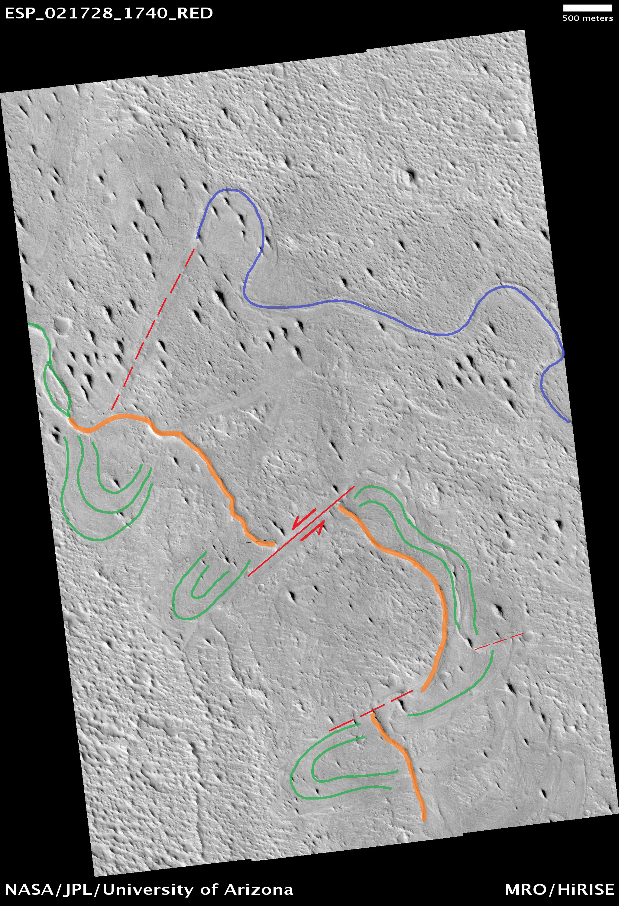
Hayden Smith and Marjorie A. Chan wrote:Inverted Meandering Rivers at a Possible Future Mars Landing Site (ESP_021728_1740) (HiClip)
This image contains interesting examples of crosscutting, sinuous and straight ridges. The ridge in the lower left of the image (orange) has gradual bends and well-defined positive relief, while the ridge in the upper right (blue) exhibits a degree of high sinuosity. Both ridges may be ancient river deposits.
In the southern part of the image, there are also possible cut bank and point bar deposition scars (green), but these do not possess visible positive relief. Although lacking relief, the sinuosity of these scars implies an ancient, mature, and low-gradient meandering river. The upper right ridge exhibits a sinuous geometry with positive relief reminiscent of a mature meandering river. Cementation of by underground fluids may have given the river deposits a higher resistance to erosion compared to the surrounding flood plain. Subsequent weathering removed the deposits in the flood plain, leaving behind the river channel positive relief.
Offsets of the lower left ridge along possible fault scarps (red) suggest that the area was cut by faults either during or after deposition of the river deposits. There also appears to be a less pronounced fault at the terminus of the upper right ridge.

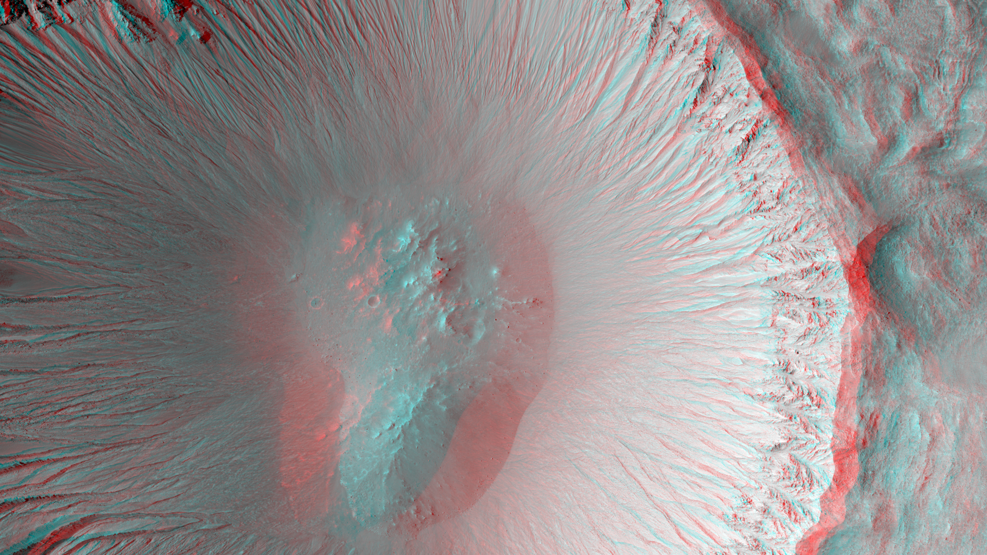
David Purcell and Marjorie A. Chan wrote:A Youthful Crater in the Cydonia Colles Region (ESP_027417_2200) (HiClip)
The central portion of this image is dominated by a sharp-rimmed crater that is roughly 5 kilometers in diameter. On its slopes, gullies show young (i.e., geologically recent) headward erosion, which is the lengthening of the gully in the upslope direction.
This crater is also remarkable for another reason. This image is part of a stereo pair, and the anaglyph of these images shows that the bottom of the crater contains a small mound. This mound hints at a possible complex crater, with the mound being a central uplift. Complex craters as small as this one are uncommon and such examples may provide clues to the lithology of the rocks underground and possibly to the impact process itself.
This is a stereo pair with ESP_025716_2200.

Kirby Runyon wrote:Down in the Paleochannels (ESP_042625_1655) (HiClip)
Transverse aeolian ridges—or TAR—are mysterious, wind-blown features that are intermediate in size between ripples and much larger sand dunes.
Ripples form from hopping sand grains, and dunes form from sand grains being blown over longer distances. One hypothesis for TAR formation is that larger grains like pebbles are rolled on top of smaller ripples; then, finer dust settles into the cracks, “inflating” the pebbles, making the TAR larger than typical ripples.
Looking between the TAR, one sees a network of ancient, beaten-up channels that were carved by water, lava, or both.
This whole area is located in Solis Planum, an interesting, tectonic terrain south of Noctis Labrynthus which generally slopes toward the south.

Alfred McEwen wrote:A Landing Site for ExoMars 2016 (ESP_042806_1785) (HiClip)
In March 2016, the European Space Agency in partnership with Roscosmos will launch the ExoMars Trace Gas Orbiter. This orbiter will also carry an Entry, Descent, and Landing Demonstration Module (EDM): a lander designed primarily to demonstrate the capability to land on Mars. The EDM will survive for only a few days, running on battery power, but will make a few environmental measurements.
The landing site is the flattest, safest place on Mars: part of Meridiani Planum, close to where the Opportunity rover landed. This image shows what this terrain is like: very flat and featureless! A full-resolution sample reveals the major surface features: small craters and wind ripples. HiRISE has been imaging the landing site region in advance of the landing, and will re-image the site after landing to identify the major pieces of hardware: heat shield, backshell with parachute, and the lander itself. The distribution of these pieces will provide information about the entry, descent and landing.
Click here for more information.
This is a stereo pair with ESP_034986_1785.

Credit: NASA/JPL-Caltech/University of Arizona
<< Previous HiRISE Update