
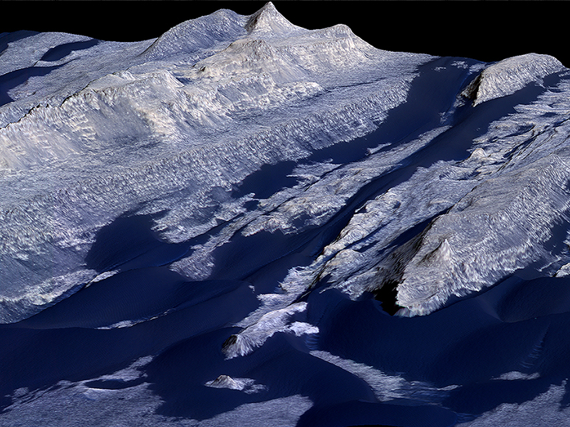
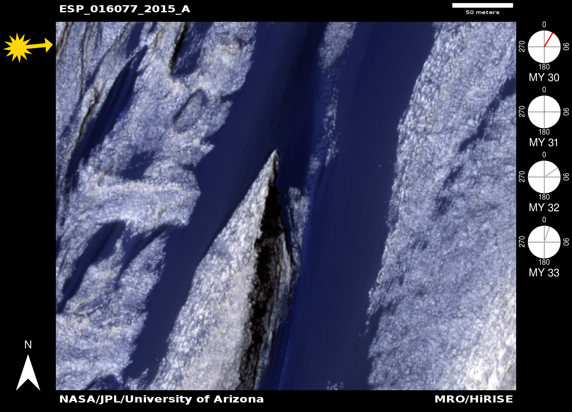
Anna Urso wrote:Becquerel Crater Dune and Yardang Interactions (ESP_034419_2015)
The creation of digital terrain models (DTMs) is an integral part of studying dune activity on Mars. They are used to determine dune heights and for precisely tying annual monitoring images to the DTM (called orthorectifying) for more accurate dune displacement calculations.
HiRISE DTMs of Becquerel Crater, located in Arabia Terra, are especial helpful for understanding dune-topography interactions. A dune field can be seen lining the north and south edges of the crater’s interior layered deposit. The summit of the deposit reaches 700 meters above the crater floor. Additionally, multiple erosional features can be observed on the surface of the deposit including: staircase weathering, knobs, and yardangs.
Yardangs are streamlined erosional landforms often resembling inverted boat hulls. These features form as a result of abrasion caused by windblown sediment. Thus, yardangs are oriented parallel to the direction of prevailing winds in the region at the time of their formation. Corridors between yardangs in Becquerel Crater reach up to 70 meters in depth and can be seen along the western edge of the deposit.
Activity has been detected in the dunes lining the deposit along with sediment removal and ripple migration within the yardang corridors. This activity is congruent with the orientation of yardangs and provides insight into past and present local wind regimes. Current dune sediment fluxes provide a conservative estimate of abrasion rates, which indicate that these yardangs have been forming over the past 6 million years.
This is a stereo pair with ESP_033707_2015.
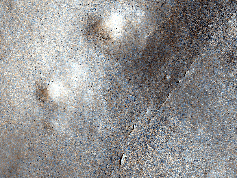
HiRISE Targeting Specialists wrote:Small Expanded Craters in the Northern Lowlands (ESP_044037_2345)
This image shows many small craters over a larger degraded one in the northern lowlands. These small craters are smoother and shallower than their counterparts closer to the equator.
Scientists believe this difference is a result of impact into a region with subsurface ice, which sublimates when exposed to the Martian atmosphere. This causes the crater to gradually expand and flatten after impact.
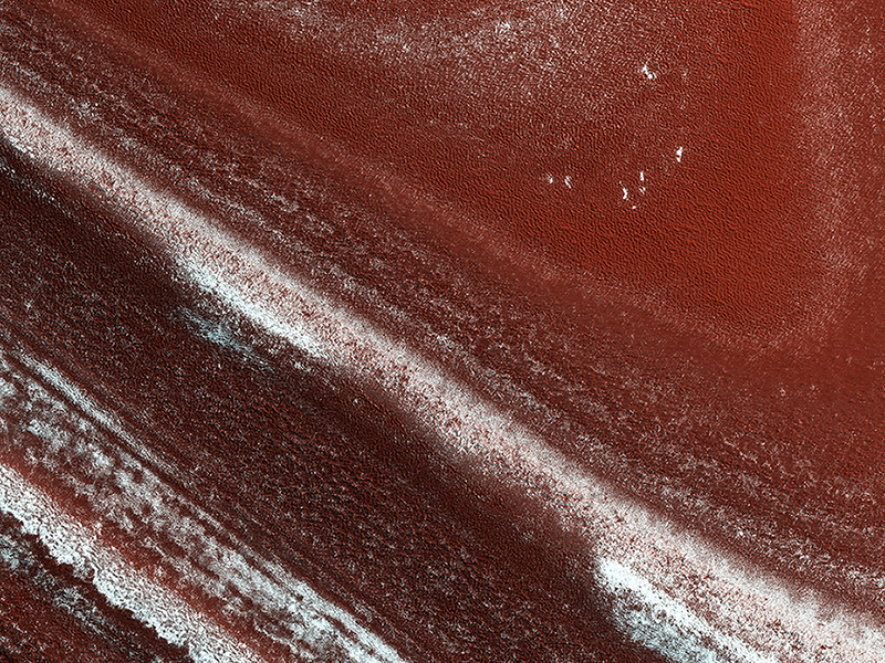
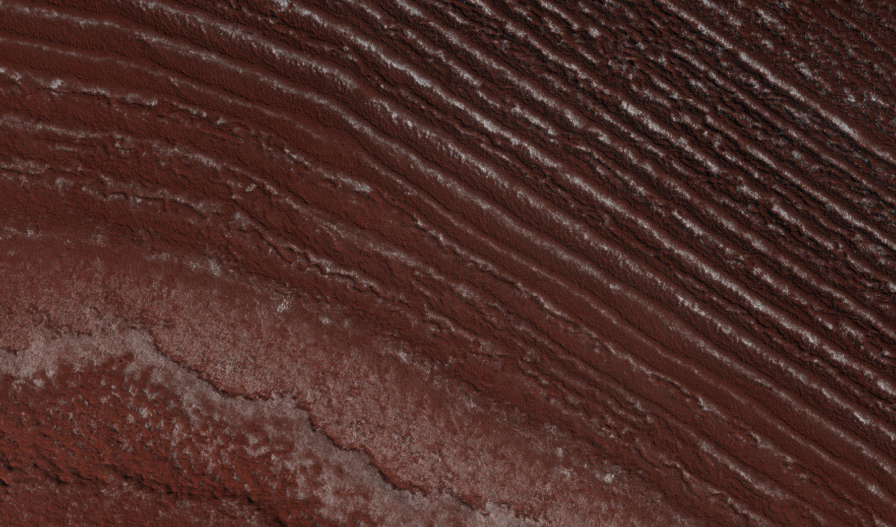
Candy Hansen wrote:North Polar Cap Layers and Ledges (ESP_045604_2645)
At the edge of Mars’ permanent North Polar cap, we see an exposure of the internal layers, each with a different mix of water ice, dust and dirt. These layers are believed to correspond to different climate conditions over the past tens of thousands of years.
When we zoom in closer, we see that the distinct layers erode differently. Some are stronger and more resistant to erosion, others only weakly cemented. The strong layers form ledges.
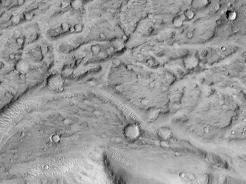
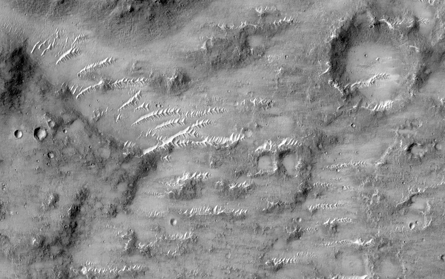
Henrik Hargitai and Ginny Gulick wrote:Ancient Streamlined Islands of the Palos Outflow Channel (ESP_045782_1820)
This image shows the northern terminus of an outflow channel located in the volcanic terrains of Amenthes Planum.
The channel sources from the Palos impact crater to the south, where water flowed into the crater from Tinto Vallis and eventually formed a paleo lake. As rising lake levels breached through the crater’s rim and inundated the plains to the north, the resulting high velocity, large discharge floods plucked out and eroded the volcanic plains scouring out the “Palos Outflow Channel” and the streamlined mesa-islands on its floor.
These streamlined forms are the eroded remnants of plains material sculpted by catastrophic floods and are not sediment deposits emplaced by lower magnitude stream flows. Both the fluvial channel floor and the volcanic island surfaces are densely cratered by impacts suggesting that both the surfaces and the flood events are ancient.
The morphology (shape) of the channel system and its islands have been preserved through the eons, but water has long been absent from this drainage system. Since then, winds have transported light-toned sediments across this terrain forming extensive dune fields within the channel system, on the floors of impact craters, and in other protected locations in the Palos Outflow Channel region.
A closer look shows chevron, or fish-bone shaped, light-toned dunes located near the top of the image where numerous smaller channels have cut through the landscape. These dunes likely started out as Transverse Aeolian Ridges (TAR) that form perpendicular to the prevailing wind direction where the wind-blown sediment supply is scarce. This intriguing morphology likely reflects changes in the prevailing wind environment over time.
Credit: NASA/JPL-Caltech/University of Arizona
<< Previous HiRISE Update