
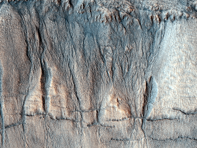
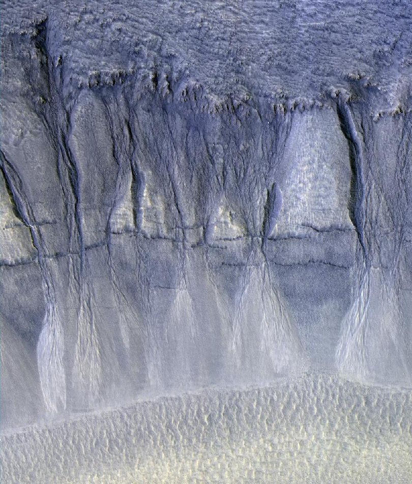
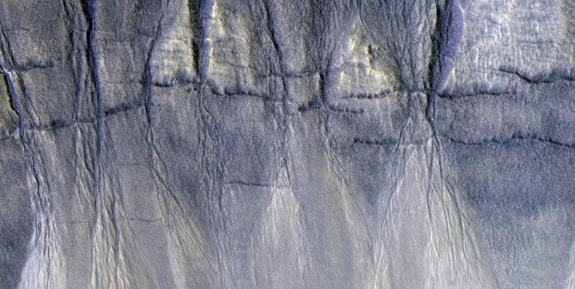
Radu Capitan, Livio Tornabene, Eric Pilles and Matt Bourassa wrote:The Evolution of Gully Features in Acidalia Planitia (ESP_052432_2325) (HiClip)
This observation captures details regarding the evolution of gully features observed in a crater in Acidalia Planitia.
A Context Camera image provides context for these gullies showing an approximately 7-kilometer diameter crater in which we see that the gullies occur exclusively on the northern wall. This is unlike most of the observed gully sites in the northern Martian hemisphere, which typically have gullies on their pole-facing slopes. Another unique observation of this set of gullies is that they start mid-way down the crater’s wall rather than cutting directly into the upper crater wall or rim.
The younger, more recently active fans are generally rougher than the older, smoother fans that are located near the base of the slope. Consistent with this interpretation, are a number of observed superposition and cross-cutting relationships. The rougher fans are always superimposed over the older, smoother ones.
Discontinuous fractures are observed to cross-cut only older features, while the most recently active portions of the gullies, in this case the channels or fans, are not cut by the fractures, but in some cases even superimpose them. This suggests that the fractures formed prior to the last phase of gully activity.
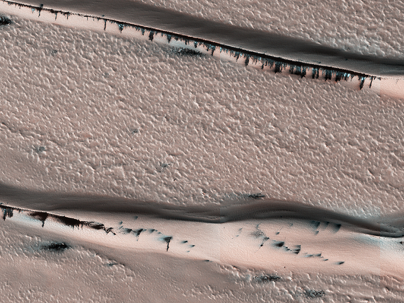
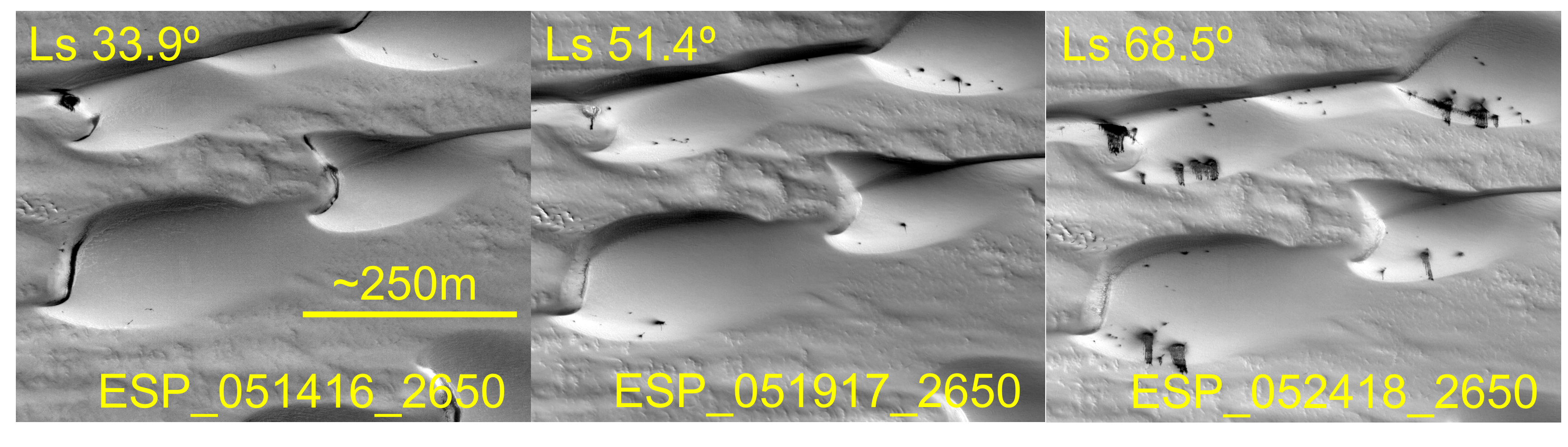
Eric Pilles, Livio Tornabene, Matthew Bourassa and Radu Capitan wrote:Defrosting Dunes within Chasma Boreale (ESP_052418_2650) (HiClip)
This image shows a dune field in Chasma Boreale, which is a large trough that cuts into the North Polar ice cap. Some of the dunes in this image are quite long and sinuous with a slight bulge at one end like a “head,” giving it the appearance of a snake.
However, most of the dunes visible here are of the type referred to as “barchan,” which are characterized by their crescent shape. For these types of dunes, the “mouth” of the crescent points in the downwind direction, indicating that the winds are traveling east-west. The diverse dune morphologies here suggest that the wind-direction changes over a very small area.
Because Mars has a similar axial tilt to Earth, it also experiences seasons. When we took this image, Mars was in late spring. At this time of year, the dunes in this image are almost completely covered by frost. But this will soon change! Small portions of the underlying dark basaltic sands of these dunes are becoming increasingly visible with the active removal of their seasonal coating of ice. A look at a series of images demonstrates the the transition from early to late spring, marked by defrosting and the gradual growth of dark spots. By summer, the dunes will be defrosted, and will appear completely black.
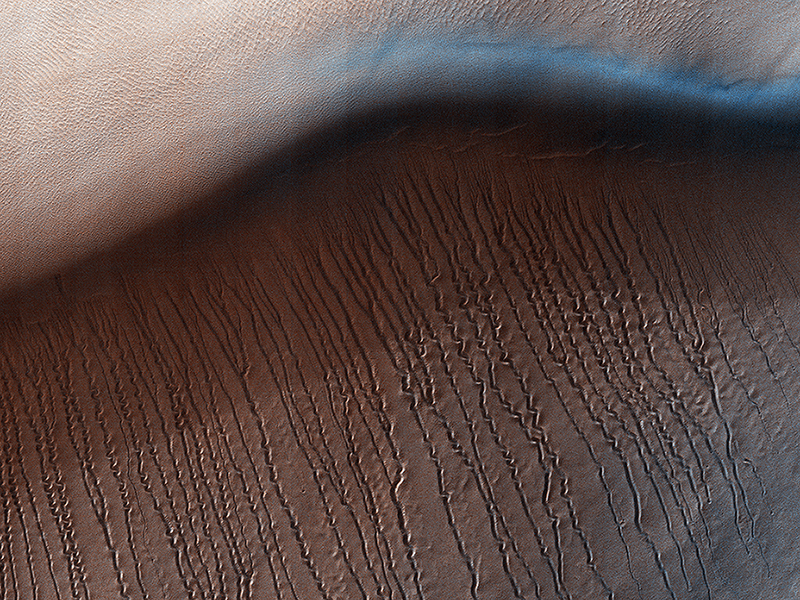
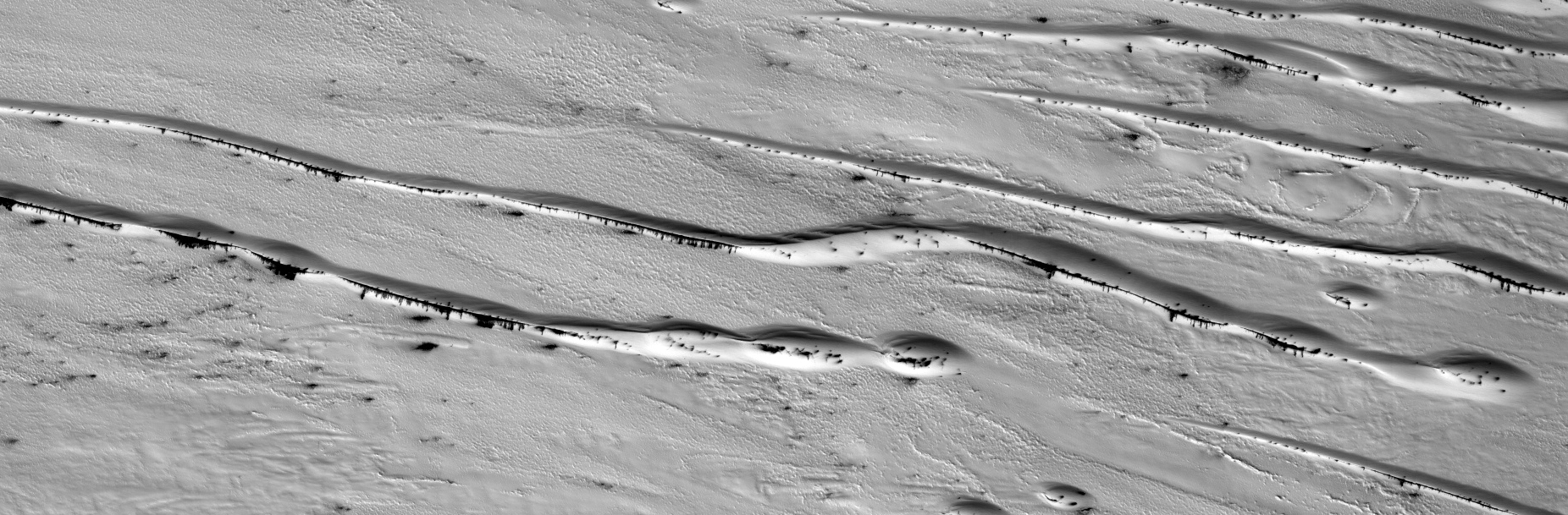
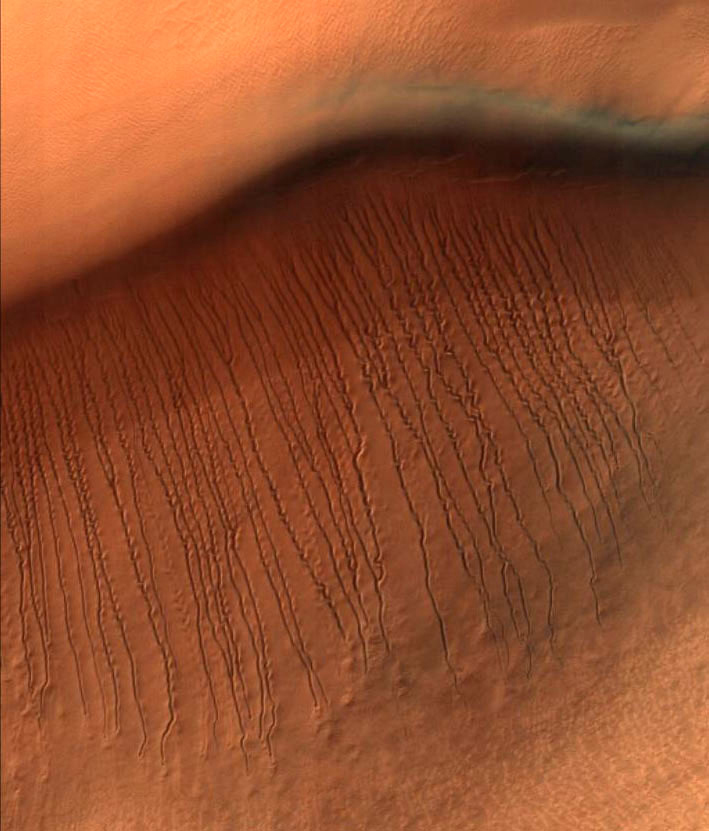
Matthew Maclay wrote:Squiggles in Hellas Planitia (ESP_051770_1345) (HiClip)
At around 2,200 kilometers in diameter, Hellas Planitia is the largest visible impact basin in the Solar System, and hosts the lowest elevations on Mars’ surface as well as a variety of landscapes. This image covers a small central portion of the basin and shows a dune field with lots of dust devil trails.
In the middle, we see what appears to be long and straight “scratch marks” running down the southeast (bottom-right) facing dune slopes. If we look closer, we can see these scratch marks actually squiggle back and forth on their way down the dune. These scratch marks are linear gullies.
Just like on Earth, high-latitude regions on Mars are covered with frost in the winter. However, the winter frost on Mars is made of carbon dioxide ice (dry ice) instead of water ice. We believe linear gullies are the result of this dry ice breaking apart into blocks, which then slide or roll down warmer sandy slopes, sublimating and carving as they go.
The linear gullies exhibit exceptional sinuosity (the squiggle pattern) and we believe this to be the result of repeated movement of dry ice blocks in the same path, possibly in combination with different hardness or flow resistance of the sand within the dune slopes. Determining the specific process that causes the formation and evolution of sinuosity in linear gullies is a question scientists are still trying to answer. What do you think causes the squiggles?
This is a stereo pair with ESP_051836_1345.
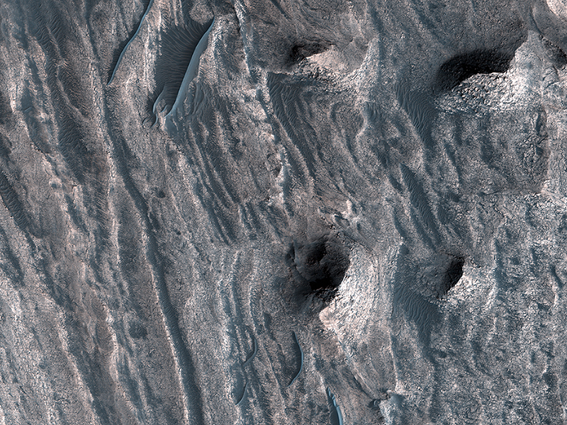
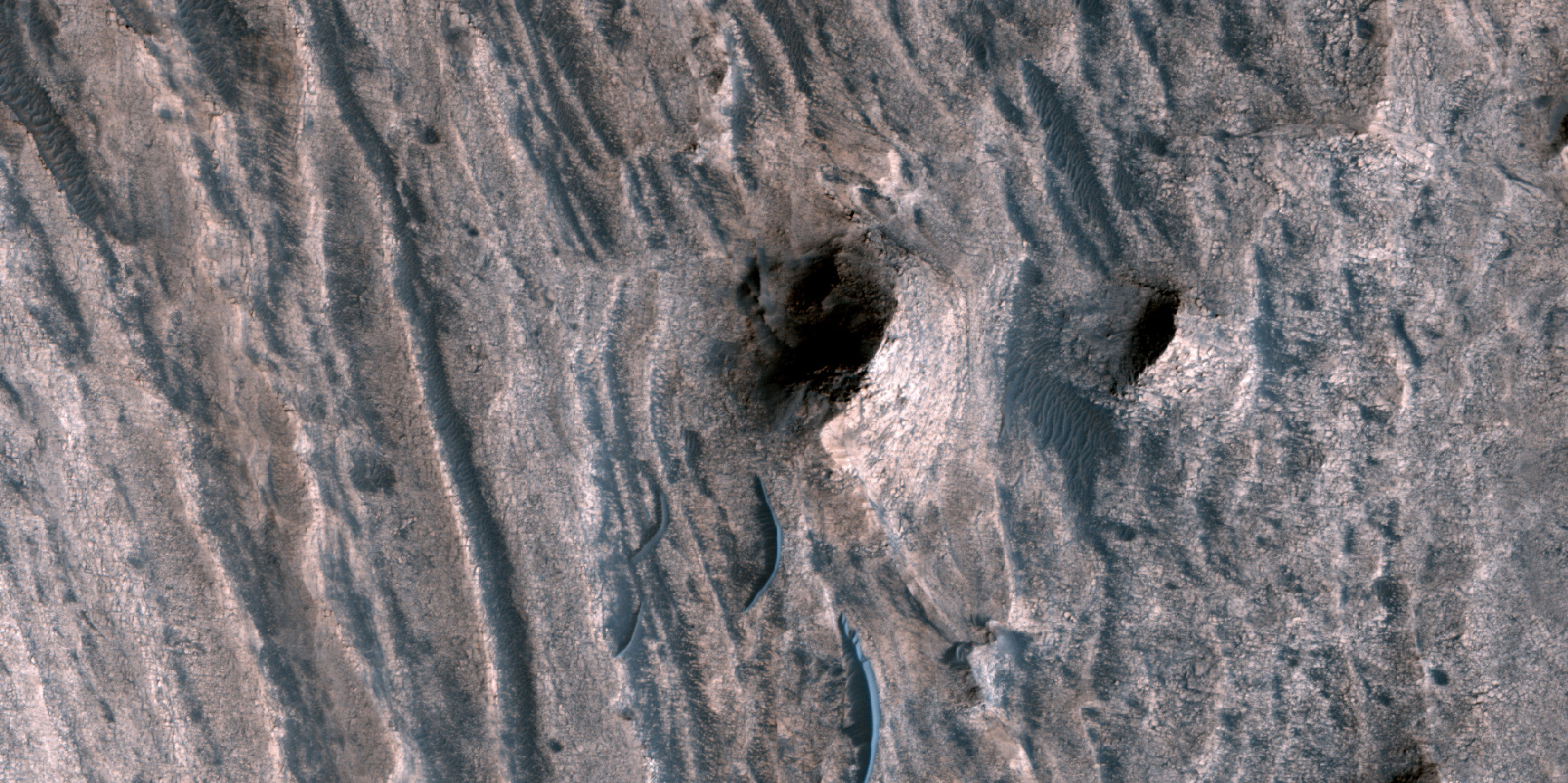
Paul Geissler wrote:A Window into the Past (ESP_051841_1750) (HiClip)
The layered sedimentary deposits inside the giant canyons of Mars have puzzled scientists for decades. These light toned deposits have fine, horizontal laminations that are unlike the rugged rim rock of the Valles Marineris.
Various ideas for the origin of the layered sediments have suggested lake deposits, wind blown dust and sand, or volcanic materials that erupted after the canyon was formed, and possibly filled with water.
One particular layered deposit, called Ceti Mensa, attracted attention because its deep red color in images collected by the Viking Orbiter mission during the 1970s. Located in west Candor Chasma in the north of the Valles Marineris, Ceti Mensa is an undulating plateau that rises 3 kilometers above the canyon floor and is bounded by steep scarps up to 1.5 kilometers in height. Deep red hues are on the west-facing scarp in particular. The red tint may be due to the presence of crystalline ferric oxide, suggesting that the material may have been exposed to heat or water, or both.
Spectral measurements by the Mars Express OMEGA and MRO CRISM instruments confirm the presence of hydrated sulfate salts, such as gypsum and kieserite . These minerals are important for two reasons. On Earth, they typically form in wet environments, suggesting that the deposits in Ceti Mensa may have formed under water. On Mars, these deposits could be valuable to future Martian colonists as fertilizer for growing crops.
In a view of the colorful west-facing scarp of Ceti Mensa, we see the interior layers of the deposit, giving us a window into the past history of the sediments as they accumulated over time. We also see layers that were previously too small to view, and a surface that is thoroughly fractured, eroded into knobs, and partially covered by young dark sand dunes.
This is a stereo pair with ESP_051986_1750.
Credit: NASA/JPL-Caltech/University of Arizona
<< Previous HiRISE Update