In the final second of the clip, there is a prominent streak that clearly is not in the equatorial plane, by perhaps 15-20 degrees. The streak is somewhat shorter than the others, so perhaps it is in a higher (slower) orbit.
Can anyone shed light on this?
APOD: Geostationary Highway through Orion (2017 Jan 16)
-
neufer

- Vacationer at Tralfamadore
- Posts: 18805
- Joined: Mon Jan 21, 2008 1:57 pm
- Location: Alexandria, Virginia
Re: APOD: Geostationary Highway through Orion (2017 Jan 16)
Guest wrote:
In the final second of the clip, there is a prominent streak that clearly is not in the equatorial plane, by perhaps 15-20 degrees. The streak is somewhat shorter than the others, so perhaps it is in a higher (slower) orbit.
Can anyone shed light on this?
- Sirius Satellite Radio satellite on it's way to short southern perigee stopover

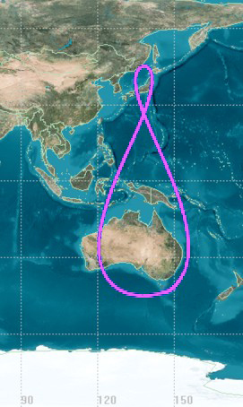
https://en.wikipedia.org/wiki/Tundra_orbit wrote: <<A Tundra orbit (Russian: Тундра) is a highly elliptical geosynchronous orbit with a high inclination (usually near 63.4°) and an orbital period of one sidereal day (about 4 minutes less than a solar day). A satellite placed in this orbit spends most of its time over a chosen area of the Earth, a phenomenon known as apogee dwell. The ground track of a satellite in a tundra orbit is a closed figure eight. The only current known users of Tundra orbits are Sirius Satellite Radio and the EKS satellite. The EKS satellite is part of a Russian early warning constellation for missile launches, and Sirius operates a constellation of three satellites used for satellite radio. The RAAN and mean anomaly of each satellite is offset by 120° so that when one satellite moves out of position, another has passed perigee and is ready to take over. Tundra orbits are used to provide high latitude users with higher elevation angles than a geostationary orbit. An argument of perigee of 270° places apogee at the northernmost point of the orbit.>>Click to play embedded YouTube video.
Art Neuendorffer
-
onteria
Re: APOD: Geostationary Highway through Orion (2017 Jan 16)
This may be a very silly question, but I'm struggling. If a satellite is geostationary, it's always above the same spot of land. If that's true, and I'm standing directly underneath it, shouldn't the satellite appear to not move at all in the sky? In my example, shouldn't the satellite be directly overhead at all times of the day and night?
This logic seems to be true no matter where on earth you are standing, a geostationary satellite should appear to not move at all relative to where you are standing, even if the stars appear to move. The stars in this video appear to be streaking across the sky.
Am i missing something?
This logic seems to be true no matter where on earth you are standing, a geostationary satellite should appear to not move at all relative to where you are standing, even if the stars appear to move. The stars in this video appear to be streaking across the sky.
Am i missing something?
-
Chris Peterson

- Abominable Snowman
- Posts: 18174
- Joined: Wed Jan 31, 2007 11:13 pm
- Location: Guffey, Colorado, USA
- Contact:
Re: APOD: Geostationary Highway through Orion (2017 Jan 16)
It could be a low inclination geosynchronous satellite. It might also be a retired geostationary satellite pushed into a higher parking orbit.Guest wrote:In the final second of the clip, there is a prominent streak that clearly is not in the equatorial plane, by perhaps 15-20 degrees. The streak is somewhat shorter than the others, so perhaps it is in a higher (slower) orbit.
Can anyone shed light on this?
Chris
*****************************************
Chris L Peterson
Cloudbait Observatory
https://www.cloudbait.com
*****************************************
Chris L Peterson
Cloudbait Observatory
https://www.cloudbait.com
-
neufer
- Vacationer at Tralfamadore
- Posts: 18805
- Joined: Mon Jan 21, 2008 1:57 pm
- Location: Alexandria, Virginia
Re: APOD: Geostationary Highway through Orion (2017 Jan 16)
Orion and almost everything else in the sky DOES appear to move to the west at about 15' of arc per minute.onteria wrote:
This may be a very silly question, but I'm struggling. If a satellite is geostationary, it's always above the same spot of land. If that's true, and I'm standing directly underneath it, shouldn't the satellite appear to not move at all in the sky? In my example, shouldn't the satellite be directly overhead at all times of the day and night?
This logic seems to be true no matter where on earth you are standing, a geostationary satellite should appear to not move at all relative to where you are standing, even if the stars appear to move. The stars in this video appear to be streaking across the sky.
Am i missing something?
If you track the sky then a geostationary satellite should appear to move east at about 15' of arc per minute.
Art Neuendorffer
-
neufer
- Vacationer at Tralfamadore
- Posts: 18805
- Joined: Mon Jan 21, 2008 1:57 pm
- Location: Alexandria, Virginia
Re: APOD: Geostationary Highway through Orion (2017 Jan 16)
Chris Peterson wrote:It could be a low inclination geosynchronous satellite.Guest wrote:
In the final second of the clip, there is a prominent streak that clearly is not in the equatorial plane, by perhaps 15-20 degrees. The streak is somewhat shorter than the others, so perhaps it is in a higher (slower) orbit.
It might also be a retired geostationary satellite pushed into a higher parking orbit.
- Retired geostationary satellites (like retired NOAA geostationary satellite scientists)
are only nudged into a slightly higher (~300 km) parking orbit when decommissioned.
(A spacecraft [or NOAA retiree] moved to a graveyard orbit will typically be passivated.)
https://en.wikipedia.org/wiki/Graveyard_orbit wrote:
<<A graveyard orbit, also called a junk orbit or disposal orbit, is an orbit that lies away from common operational orbits, typically a supersynchronous orbit well above synchronous orbit. Satellites are moved into such orbits at the end of their operational life to reduce the probability of colliding with operational spacecraft or generating space debris. In order to obtain a license to provide telecommunications services in the United States, the Federal Communications Commission (FCC) requires all geostationary satellites launched after March 18, 2002, to commit to moving to a graveyard orbit at the end of their operational life. U.S. government regulations require a boost, Δ H of ~300 km. De-orbiting a geostationary satellite requires a delta-v of about 1,500 metres per second, whereas re-orbiting it to a graveyard orbit only requires about 11 metres per second. The transfer to a graveyard orbit above geostationary orbit requires the same amount of fuel as a satellite needs for about three months of stationkeeping. It also requires a reliable attitude control during the transfer maneuver. While most satellite operators try to perform such a maneuver at the end of their satellites' operational lives, through 2005 only about one-third succeeded. However, as of 2011, most recently decommissioned geosynchronous spacecraft were said to have been moved to a graveyard orbit.>>
Art Neuendorffer
-
alter-ego

- Serendipitous Sleuthhound
- Posts: 1120
- Joined: Mon Apr 21, 2008 4:51 am
- Location: Redmond, WA
Re: APOD: Geostationary Highway through Orion (2017 Jan 16)
Guest wrote:In the final second of the clip, there is a prominent streak that clearly is not in the equatorial plane, by perhaps 15-20 degrees. The streak is somewhat shorter than the others, so perhaps it is in a higher (slower) orbit.
Can anyone shed light on this?
neufer wrote:Sirius Satellite Radio satellite on it's way to short southern perigee stopover
That satellite is an imposter - not geosynchronous.Chris Peterson wrote:It could be a low inclination geosynchronous satellite. It might also be a retired geostationary satellite pushed into a higher parking orbit.
It goes by RBSP A, has a highly elliptical orbit making 2.68 revolutions per day. The apoapsis is about 5000km closer than the geostationary orbit radius. The M42 crossing(s) occur while near the furthest point, and in the video the orbital motion is in the opposite direction than the geosynchronous satellites - that's why it appears to be moving slower. There is also an RBSP B which tracks through M42 the same way at different times and thus different longitudes.
This interloper provides a good clue as the longitude of James DeYoung's video location. I used Stellarium to globally scan possible observing location locations. Across the US are two possible locations where RBSP A & B cross M42 like the video, however given the brighter satellites (better sun angle) and more similar satellite traffic density, RBSP A is the best candidate and recorded in the Virginias region.
- RSPB A Orbit & Ground Track by Heavens Above
A pessimist is nothing more than an experienced optimist