Comments and questions about the
APOD on the main view screen.
-
jhagerty@juno.com
Post
by jhagerty@juno.com » Fri Jan 04, 2013 8:15 am
So where is TMA-1?
-
Adrian Lister
Post
by Adrian Lister » Fri Jan 04, 2013 9:28 am
I have the APOD Wallpaper software that brings up each day's APOD image on my PC automatically. Can anyone tell me how to get the day's explanation on the screen automatically at the same time? According to some reports, there is an item on the right-click menu of the wallpaper icon, but I don't see it. Thanks!
AdrianLister@blueyonder.co.uk
-
neufer
- Vacationer at Tralfamadore
- Posts: 18805
- Joined: Mon Jan 21, 2008 1:57 pm
- Location: Alexandria, Virginia
Post
by neufer » Fri Jan 04, 2013 12:23 pm
Art Neuendorffer
-
saturno2
- Commander
- Posts: 758
- Joined: Wed Jun 29, 2011 10:05 pm
Post
by saturno2 » Fri Jan 04, 2013 1:13 pm
Diameter Tycho crater 85 km
Central peak wide 15 km
Tycho crater chemical composition: anorthosite ( aluminium rich )
Struck by the different surface appearance compared to the
surface of Mars.
-
Ron-Astro Pharmacist
- Resistored Fizzacist
- Posts: 889
- Joined: Thu Jan 03, 2013 10:34 pm
- AKA: Fred
- Location: Idaho USA
Post
by Ron-Astro Pharmacist » Fri Jan 04, 2013 5:00 pm
Great picture. Talk about a "Giant Leap" Speaking of magnetic anomalies. In "First Man" they mention they worries Apollo 11 had regarding them. Did they every pose a problem with the future flights?

Ron
-
Ron-Astro Pharmacist
- Resistored Fizzacist
- Posts: 889
- Joined: Thu Jan 03, 2013 10:34 pm
- AKA: Fred
- Location: Idaho USA
Post
by Ron-Astro Pharmacist » Fri Jan 04, 2013 5:03 pm
Or a resource about that period in time. The book has respaked my interest.
-
neufer
- Vacationer at Tralfamadore
- Posts: 18805
- Joined: Mon Jan 21, 2008 1:57 pm
- Location: Alexandria, Virginia
Post
by neufer » Fri Jan 04, 2013 9:25 pm
http://monsters.monstrous.com/roc.htm wrote:
<<There are four stories about the roc in the Arabian Nights. In one story involving Sinbad, the roc unknowingly carries Sinbad to safety after a shipwreck. Sinbad was then stranded in a Roc’s nest on top of a mountain where he found an egg as large as 148 hen’s eggs. When the adult bird returned to its nest, Sinbad left his confinement by lashing himself to the Roc’s leg with his turban, without the bird even noticing him. He flew with it so high into the sky that he lost sight of earth. Eventually, he was able to escape when the Roc flew near another island.>>
Art Neuendorffer
-
Anthony Barreiro
- Turtles all the way down
- Posts: 793
- Joined: Wed May 11, 2011 7:09 pm
- Location: San Francisco, California, Turtle Island
Post
by Anthony Barreiro » Fri Jan 04, 2013 11:12 pm
neufer wrote: http://monsters.monstrous.com/roc.htm wrote:
<<There are four stories about the roc in the Arabian Nights. In one story involving Sinbad, the roc unknowingly carries Sinbad to safety after a shipwreck. Sinbad was then stranded in a Roc’s nest on top of a mountain where he found an egg as large as 148 hen’s eggs. When the adult bird returned to its nest, Sinbad left his confinement by lashing himself to the Roc’s leg with his turban, without the bird even noticing him. He flew with it so high into the sky that he lost sight of earth. Eventually, he was able to escape when the Roc flew near another island.>>
That huge boulder in the middle of the central depression caught my eye the first time I saw this photo. I recall reading that the central depression is the size of a football stadium, so the boulder is truly monstrous. I hope LRO operates long enough for us to see what hatches from that cosmic egg.
May all beings be happy, peaceful, and free.
-
Boomer12k
- :---[===] *
- Posts: 2691
- Joined: Sun Apr 22, 2007 12:07 am
Post
by Boomer12k » Sat Jan 05, 2013 12:40 am
When you "cast a long shadow", this is what happens.
Funny how the mountains look like they are made of modeling clay.

Thanks for the repeat.
:---[===] *
-
neufer
- Vacationer at Tralfamadore
- Posts: 18805
- Joined: Mon Jan 21, 2008 1:57 pm
- Location: Alexandria, Virginia
Post
by neufer » Sat Jan 05, 2013 4:23 am
Anthony Barreiro wrote:
That huge boulder in the middle of the central depression caught my eye the first time I saw this photo. I recall reading that the central depression is the size of a football stadium, so the boulder is truly monstrous. I hope LRO operates long enough for us to see what hatches from that cosmic egg.
I'm guessing there's a smaller roc inside.
Art Neuendorffer
-
Beyond
- 500 Gigaderps
- Posts: 6889
- Joined: Tue Aug 04, 2009 11:09 am
- Location: BEYONDER LAND
Post
by Beyond » Sat Jan 05, 2013 5:09 am
neufer wrote:Anthony Barreiro wrote:
That huge boulder in the middle of the central depression caught my eye the first time I saw this photo. I recall reading that the central depression is the size of a football stadium, so the boulder is truly monstrous. I hope LRO operates long enough for us to see what hatches from that cosmic egg.
I'm guessing there's a smaller roc inside.
*Rock-on*, even if you're not Jimmy Dean.

To find the Truth, you must go Beyond.
-
Ann
- 4725 Å
- Posts: 13420
- Joined: Sat May 29, 2010 5:33 am
Post
by Ann » Sat Jan 05, 2013 5:27 am
Luna-tic-saurus Rex. For sure.
Wait. Luna-roc-saurus Rex.
Ann
Color Commentator
-
hornetelectric
Post
by hornetelectric » Mon Jan 07, 2013 4:48 am
Looks like some type of flow around the mountainous protrusion, as if water influenced movement of material. I also see faults, they look like they interact with the apparent flows. What I see as flows of moon 'soil' may be similar to some apparent flows on Mars. Would like to hear from other for related opinion.
Thanks, Philip K
hornetelectric@mho.com
-
neufer
- Vacationer at Tralfamadore
- Posts: 18805
- Joined: Mon Jan 21, 2008 1:57 pm
- Location: Alexandria, Virginia
Post
by neufer » Mon Jan 07, 2013 1:56 pm
hornetelectric wrote:
Looks like some type of flow around the mountainous protrusion, as if water influenced movement of material. I also see faults, they look like they interact with the apparent flows. What I see as flows of moon 'soil' may be similar to some apparent flows on Mars. Would like to hear from other for related opinion.
I'm guessing they are claw marks:
http://asterisk.apod.com/viewtopic.php? ... 85#p190442Art Neuendorffer
-
Anthony Barreiro
- Turtles all the way down
- Posts: 793
- Joined: Wed May 11, 2011 7:09 pm
- Location: San Francisco, California, Turtle Island
Post
by Anthony Barreiro » Mon Jan 07, 2013 8:30 pm
hornetelectric wrote:Looks like some type of flow around the mountainous protrusion, as if water influenced movement of material. I also see faults, they look like they interact with the apparent flows. What I see as flows of moon 'soil' may be similar to some apparent flows on Mars. Would like to hear from other for related opinion.
Thanks, Philip K
hornetelectric@mho.com
The central peak in an impact crater such as Tycho is created when surface material rebounds back up from the impact site. It makes sense that some of this material would flow back down the sides of the peak, and if the material was melted by the force of the impact, the flow structure would look liquid.
Regarding evidence of flowing water on Mars, I would guess that planetary scientists are able to distinguish between impact phenomena and waterways.
May all beings be happy, peaceful, and free.
-
Anthony Barreiro
- Turtles all the way down
- Posts: 793
- Joined: Wed May 11, 2011 7:09 pm
- Location: San Francisco, California, Turtle Island
Post
by Anthony Barreiro » Mon Jan 07, 2013 8:31 pm
neufer wrote:Anthony Barreiro wrote:
That huge boulder in the middle of the central depression caught my eye the first time I saw this photo. I recall reading that the central depression is the size of a football stadium, so the boulder is truly monstrous. I hope LRO operates long enough for us to see what hatches from that cosmic egg.
I'm guessing there's a smaller roc inside.
And inside the smaller roc a littler roc, and so ad infinitum?
May all beings be happy, peaceful, and free.
-
Beyond
- 500 Gigaderps
- Posts: 6889
- Joined: Tue Aug 04, 2009 11:09 am
- Location: BEYONDER LAND
Post
by Beyond » Mon Jan 07, 2013 11:28 pm
Anthony Barreiro wrote:neufer wrote:Anthony Barreiro wrote:
That huge boulder in the middle of the central depression caught my eye the first time I saw this photo. I recall reading that the central depression is the size of a football stadium, so the boulder is truly monstrous. I hope LRO operates long enough for us to see what hatches from that cosmic egg.
I'm guessing there's a smaller roc inside.
And inside the smaller roc a littler roc, and so ad infinitum?
That's the story of 'Rock & Roll'. It just keeps on Rockin'.
To find the Truth, you must go Beyond.
-
neufer
- Vacationer at Tralfamadore
- Posts: 18805
- Joined: Mon Jan 21, 2008 1:57 pm
- Location: Alexandria, Virginia
Post
by neufer » Tue Jan 08, 2013 3:47 am
Anthony Barreiro wrote:neufer wrote:Anthony Barreiro wrote:
That huge boulder in the middle of the central depression caught my eye the first time I saw this photo. I recall reading that the central depression is the size of a football stadium, so the boulder is truly monstrous. I hope LRO operates long enough for us to see what hatches from that cosmic egg.
I'm guessing there's a smaller roc inside.
And inside the smaller roc a littler roc, and so ad infinitum?
http://en.wikipedia.org/wiki/Bernard_de_la_Harpe wrote:
<<Jean-Baptiste Bénard de la Harpe (b. 4 Feb 1683, in Saint-Malo- d. 26 September 1765) was a French explorer who is credited with the discovery of Little Rock, Arkansas. He was the first known French explorer to set foot in the future state of Oklahoma.
In 1722, La Harpe ascended the Arkansas River and found two distinct rock formations on the Arkansas River, the smaller one the South bank he named La Petite Roche and the larger on the North bank La Grande Roche. He based a trading post near the smaller formation, as a Quapaw Indian settlement was stationed there. He explored the Arkansas River another 25 leagues (70 miles) above Little Rock.
[Three years before] La Harpe established a trading post in April 1719 on the Red River near what is now Texarkana, Texas. La Harpe followed the Red River upstream, probably to the vicinity of present day Idabel, Oklahoma.
He then turned north to cross the rugged east-west ridges of the Ouachita (WOSH-i-taw) Mountains which rise more than one thousand feet above the intervening valleys. On September 3, after 23 days of traveling, La Harpe and his party reached a large settlement; archaeological evidence points to it being located about 13 miles south of Tulsa, Oklahoma near the western bank of the Arkansas River. The presence of various Wichita tribes suggests that the village was a melting pot and probably a trade center for the entire region. The Wichita gave La Harpe a friendly reception, so friendly that two Black slaves in his group wanted to stay with the Indians rather than return with La Harpe. La Harpe noted that the Wichita had horses, were excellent farmers, and that game in the area was abundant. The Wichita told him they were cannibals. While in the Wichita village, a Chickasaw trader visited. This was disturbing to La Harpe as the Chickasaw, who lived in Mississippi, were allies of the British. La Harpe left to return to his starting point on Sept 13, 1719 and arrived on October 13. En route, an Indian man and woman traveling with him were killed by Apaches and La Harpe became lost in the mountains and had to eat his horses.>>
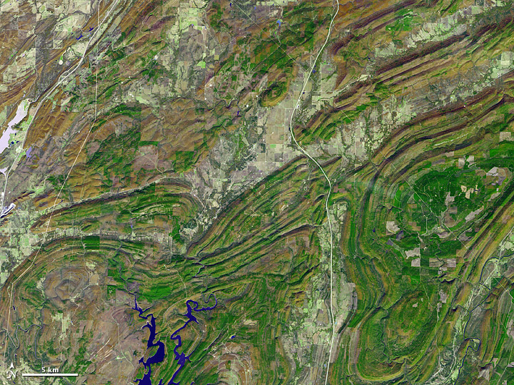
- [b][color=#0000FF]On November 13, 2002, the Advanced Spaceborne Thermal Emission and Reflection Radiometer (ASTER) on NASA’s Terra satellite captured this image. This picture combines infrared, red, and green wavelengths of light, and roughly approximates true color. The mountains are complex, nearly forming paisley patterns with their long, folding contours. Low-lying areas between the slopes accommodate water bodies, crops, towns, and roads. Pale-hued highways cut through the region, running primarily north-south.[/color][/b]
http://earthobservatory.nasa.gov/IOTD/view.php?id=46485 wrote:
<<
The Ouachita (WOSH-i-taw) Mountains record a complicated geologic history spanning hundreds of millions of years. Long before the first dinosaur evolved, what is now the southern central United States sat at the bottom of an ancient sea. From roughly 550 to 340 million years ago, the area collected sediments eroding off nearby continents, as well as detritus of sea life. Starting around 340 million years ago, a tectonic plate that had previously been attached to Africa and South America collided with the North American plate. The process helped form the supercontinent of Pangaea, and it thrust the ancient sea floor skyward. The similarities between rock layers of the Ouachita Mountains and the Appalachian Mountains indicate that they were part of a massive mountain chain formed by this collision. Once elevated, the mountains soon commenced eroding. About 200 million years ago, Pangaea began to break apart. The breakup wrenched apart the supersized mountain range, leaving a wide swath of low-lying land between the Ouachita Mountains in the west and the Appalachian Mountains in the east. Low-profile land persists today across much of the southeastern United States.>>
Art Neuendorffer
-
cljohnston108
- Asternaut
- Posts: 7
- Joined: Thu Feb 03, 2011 8:38 am
Post
by cljohnston108 » Fri Jan 11, 2013 11:57 am
Would love to see the Apollo sites in this resolution!
-
neufer
- Vacationer at Tralfamadore
- Posts: 18805
- Joined: Mon Jan 21, 2008 1:57 pm
- Location: Alexandria, Virginia
Post
by neufer » Fri Jan 11, 2013 2:50 pm
cljohnston108 wrote:
Would love to see the Apollo sites in this resolution!
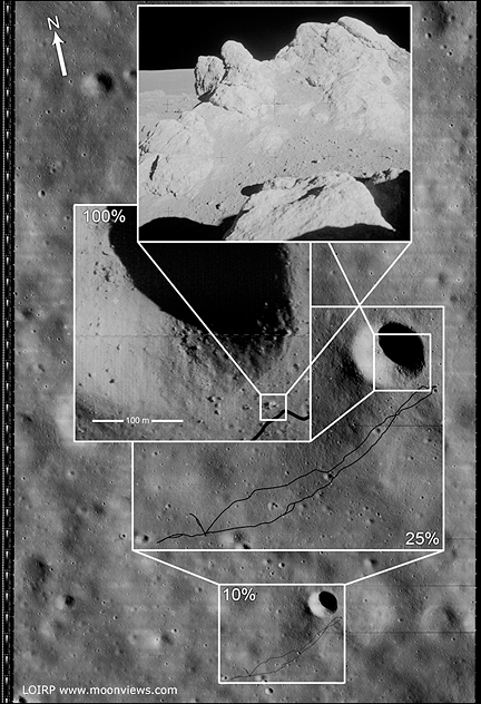
http://www.moonviews.com/archives/lro/ wrote:
Lunar Orbiter Image Recovery Project (LOIRP) Releases New High Resolution Image of The Apollo 14 Landing Site With EVA Details
June 12, 2009
<<This photo (Frame 133-H2) of the future Apollo 14 landing site was taken by Lunar Orbiter III on 20 February 1967 at an orbital altitude of 46.7 km. The resolution of the image is around 0.8 meters per pixel. The area covered by this image is 4.52167 x 5.77666 km.
Figure 1 shows the image unlabeled. In Figure 2 we have overlaid the EVA route upon this image so as to show where the crew set foot. While the crew were supposed to visit Cone crater they stopped 20 meters short of doing so due to some confusion as to their exact location. That said, they did visit some large rocks located adjacent to Cone crater's rim. The enlargement of this Lunar Orbiter image clearly shows some large rocks poised near the crater's rim. The inset photo shows the largest outcropping as photographed by the crew on the surface.
NOTE: We originally posted these files in an incorrect orientation. This was due to how the images originally show up when they are retrieved from the original tapes. Thanks to all of you eagle-eyed viewers we caught that. We have replaced those earlier files with ones that are correctly oriented to North, South, East, and West.
This image has been recovered in its original high resolution format from original Lunar Orbiter project data tapes using restored tape drive hardware and will eventually be submitted to the PDS (Planetary Data System). The full resolution is online here at NLSI.
LOIRP Note: We will be putting the full resolution version of this image on the NASA Lunar Science Institute website with the layers preserved for Photoshop for all you folks to have fun with! We only ask that you send us copies of what you do and credit us if you publish it anywhere.>>
Art Neuendorffer

 Sunrise at Tycho