APOD: Mount Everest Star Trails (2018 Dec 01)

Comments and questions about the APOD on the main view screen.
User avatar
APOD Robot
Otto Posterman
Posts: 5517
Joined: Fri Dec 04, 2009 3:27 am

APOD: Mount Everest Star Trails (2018 Dec 01)

Post by APOD Robot » Sat Dec 01, 2018 5:06 am

Image Mount Everest Star Trails

Explanation: The highest peak on planet Earth is framed in this mountain and night skyscape. On September 30, the digital stack of 240 sequential exposures made with a camera fixed to a tripod at an Everest Base Camp captured the sheer north face of the Himalayan mountain and foreground illuminated by bright moonlight. Taken over 1.5 hours, the sequence also recorded colorful star trails. Reflecting the planet's daily rotation on its axis, their motion is along gentle concentric arcs centered on the south celestial pole, a point well below the rugged horizon. The color of the trails actually indicates the temperatures of the stars. Blueish hues are from hotter stars, and yellow to reddish hues are from stars cooler than the Sun.

<< Previous APOD This Day in APOD Next APOD >>

User avatar
Ann
4725 Å
Posts: 13711
Joined: Sat May 29, 2010 5:33 am

Re: APOD: Mount Everest Star Trails (2018 Dec 01)

Post by Ann » Sat Dec 01, 2018 6:31 am

Beautiful, but the overall bluish hue of the sky is quite striking to me. It's not just the hot stars that paint the sky blue.

Could we be looking at a moonlit scene? Because sunlight reflected from the Moon makes the sky blue, just like direct sunlight does.

Ann
Color Commentator

User avatar
JohnD
Tea Time, Guv! Cheerio!
Posts: 1586
Joined: Wed Feb 16, 2005 2:11 pm
Location: Lancaster, England

Re: APOD: Mount Everest Star Trails (2018 Dec 01)

Post by JohnD » Sat Dec 01, 2018 11:01 am

Anne, there is a distinct shadow on the face of the mountain in front of Chomolungma, and on the scree slopes to the left of the camera, that would indicate the Moon at about 1100, out of frame in the top left hand corner of the picture.

BUT, that shadow is so sharp! Has the terrestrial part of the image been masked, and seen in one exposure, when the blurb describes a "digital stack of 240 sequential exposures ... Taken over 1.5 hours" ? I have to say that when digital photography allows this sort of jiggery-pokery, it reflects this age of 'fake news', and IMHO devalues the photgrapher's art and expertise. Why could this not have been a 90 minute exposure? The star trails would have shown just as well.

John

De58te
Commander
Posts: 584
Joined: Mon Sep 30, 2013 6:35 pm

Re: APOD: Mount Everest Star Trails (2018 Dec 01)

Post by De58te » Sat Dec 01, 2018 11:43 am

Great picture. I hardly see a picture of the north face. Almost all articles about Everest or Edmund Hillary show pictures of the south or east face. In fact I think the only other picture of the north face I seen was a much closer black and white photo of the top third peak taken from a plane. And too think that somebody actually climbed the incredibly difficult north face. Now I can see why it is difficult.

User avatar
Chris Peterson
Abominable Snowman
Posts: 18491
Joined: Wed Jan 31, 2007 11:13 pm
Location: Guffey, Colorado, USA

Re: APOD: Mount Everest Star Trails (2018 Dec 01)

Post by Chris Peterson » Sat Dec 01, 2018 2:54 pm

Ann wrote: Sat Dec 01, 2018 6:31 am Beautiful, but the overall bluish hue of the sky is quite striking to me. It's not just the hot stars that paint the sky blue.

Could we be looking at a moonlit scene? Because sunlight reflected from the Moon makes the sky blue, just like direct sunlight does.
APOD Robot wrote: Sat Dec 01, 2018 5:06 am On September 30, the digital stack of 240 sequential exposures made with a camera fixed to a tripod at an Everest captured the sheer north face of the Himalayan mountain and foreground illuminated by bright moonlight.
On 30 September the Moon was waning gibbous, at a 70% phase. (It was also south of the zenith most of the night, making it problematic to illuminate the north face. It seems likely this image was made early in the evening, when the Moon was a little north of east and low in the sky.)
Chris

*****************************************
Chris L Peterson
Cloudbait Observatory
https://www.cloudbait.com

User avatar
Chris Peterson
Abominable Snowman
Posts: 18491
Joined: Wed Jan 31, 2007 11:13 pm
Location: Guffey, Colorado, USA

Re: APOD: Mount Everest Star Trails (2018 Dec 01)

Post by Chris Peterson » Sat Dec 01, 2018 3:00 pm

JohnD wrote: Sat Dec 01, 2018 11:01 am BUT, that shadow is so sharp! Has the terrestrial part of the image been masked, and seen in one exposure, when the blurb describes a "digital stack of 240 sequential exposures ... Taken over 1.5 hours" ? I have to say that when digital photography allows this sort of jiggery-pokery, it reflects this age of 'fake news', and IMHO devalues the photgrapher's art and expertise. Why could this not have been a 90 minute exposure? The star trails would have shown just as well.
You can't take a 90 minute exposure with a DSLR- the thermal noise (dark current) would consume nearly all the dynamic range. So we typically use exposure times on the order of 30 seconds for images like this, because that is pretty optimal for most digital cameras. Also, most cameras have a 30-second maximum exposure without switching to some kind of external controller.

Why is summing up a sequence to create a long exposure any different from a single exposure? And why is it problematic to use only a single image for the foreground? That provides a much more true-to-visual-reality image than one where the shadows move over 90 minutes.
Chris

*****************************************
Chris L Peterson
Cloudbait Observatory
https://www.cloudbait.com

User avatar
neufer
Vacationer at Tralfamadore
Posts: 18805
Joined: Mon Jan 21, 2008 1:57 pm
Location: Alexandria, Virginia

Dr. Suess & the Qomolangma

Post by neufer » Sat Dec 01, 2018 6:45 pm

http://www.everest1953.co.uk/geology-of-mount-everest wrote: Geology of Mount Everest

<<The three formations, or units, which make up the geology of Mount Everest are divided into sections. Geologists have named these, from the bottom to the summit respectively, the Rongbuk Formation, the North Col Formation and the Qomolangma Formation. These sections, or units, are divided by a low-angle fault, or a ‘detachment’, each one being forced over the next to form a, sort of, zigzag pattern.

The Qomolangma Formation consists of layers of Ordovician limestone and recrystallized dolomite, along with siltstone and laminae, together forming colours ranging from white to dark gray. Starting at 8,600 meters above sea level (above Yellow Band), the Qomolangma Formation ends at the summit. Tests of the limestone found here have been conducted to reveal small remains of ostracods, trilobites and crinoids. Gansser was one of the first people to report such findings. The bottom of the summit pyramid and the ‘Third Step’ is made up of a bed, 60 meters in depth, which sticks out from about 70 meters beneath the top of Mount Everest. This bed contains trapped sediments, which are sealed in by the production of biofilms from micro-organisms, such as cyanobacteria, usually in marine waters that are quite shallow. This section is scattered with a number of high angle faults, which finish at the Qomolangma Detachment. This causes a separation from the ‘Yellow band’.

The middle part of Mount Everest is known as the North Col Formation, 7,000 to 8,600 meters. The top 400 meters, named the ‘Yellow Band’, is formed from linked beds of a brown, Middle Cambrian, marble (diopside-epidote-bearing), muscovite-biotite phyllite (which contain silicate minerals) and semischist (a partly metamorphosed, layered sedimentary rock). By analysing some of the marble taken from around 8,300 meters, it has been discovered to contain up to 5% crinoid ossicles (marine organisms which have a skeleton, formed from calcareous plates), which have been recrystallized. The top five meters, just before the Qomolangma Detachment, is a badly deformed area and is separated from the Qomolangma Formation by a fault breccia, which is between 5 and 40 centimeters thick. The rest of the North Col Formation is formed from layers of minor marble, schist and phyllite. From 7,600 to 8,200 meters, schist (biotite-sericite-quartz) can be found in small amounts, along with chlorite-biotite phyllite and biotite-quartz phyllite. The bottom, consisting of the last 600 meters, is formed by the combination of, biotite-quartz schist, biotite-calcite-quartz schist and epidote-quartz schist, occasionally separated by a thin quartzose marble layer. The formation of these rocks is thought to have occurred due to the metamorphism of deep sea flysch (Middle Cambrian) and made up of sandy limestone, calcareous sandstone and mudstone, among others. The ‘Lhotse detachment’ (a regional thrust fault) lies at the bottom of the North Col Formation, dividing it from the Rongbuk Formation.

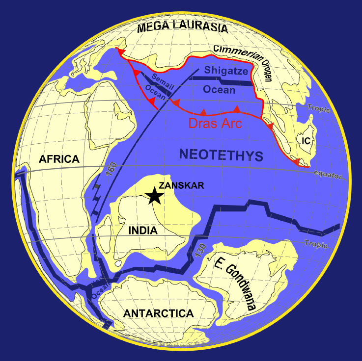
It is thought that the summit of Mount Everest started at the bottom of the ancient Tethys Sea, the motion of the Indian subcontinental plate and the urasian continental plate colliding, about 30 – 50 million years ago, caused the mountain to rise up and become the highest mountain on the Earth.>>
https://en.wikipedia.org/wiki/Tethys_Ocean wrote:
<<The Tethys Ocean (Ancient Greek: Τηθύς), Tethys Sea or Neotethys was an ocean during much of the Mesozoic Era located between the ancient continents of Gondwana and Laurasia, before the opening of the Indian and Atlantic oceans during the Cretaceous Period.

In 1893, the Austrian geologist Dr. Eduard Suess (August 1831 – 26 April 1914) proposed the theory that an ancient and extinct inland sea had once existed between Laurasia and the continents which formed Gondwana II. He named it the Tethys Sea after the Greek sea goddess Tethys. He provided evidence for his theory using fossil records from the Alps and Africa. In the following decades during the 20th century, "mobilist" geologists such as Uhlig (1911), Diener (1925), and Daque (1926) regarded Tethys as a large trough between two supercontinents which lasted from the late Palaeozoic until continental fragments derived from Gondwana obliterated it.

From the Ediacaran (600 Mya) into the Devonian (360 Mya), the Proto-Tethys Ocean existed and was situated between Baltica and Laurentia to the north and Gondwana to the south. From the Silurian (440 Mya) through the Jurassic periods, the Paleo-Tethys Ocean existed between the Hunic terranes and Gondwana. Over a period of 400 million years, continental terranes intermittently separated from Gondwana in the Southern Hemisphere to migrate northward to form Asia in the Northern Hemisphere.

About 250 Mya, during the Triassic, a new ocean began forming in the southern end of the Paleo-Tethys Ocean. A rift formed along the northern continental shelf of Southern Pangaea (Gondwana). Over the next 60 million years, that piece of shelf, known as Cimmeria, traveled north, pushing the floor of the Paleo-Tethys Ocean under the eastern end of northern Pangaea (i.e.Laurasia). The Tethys Ocean formed between Cimmeria and Gondwana, directly over where the Paleo-Tethys used to be.

During the Jurassic period about 150 Mya, Cimmeria finally collided with Laurasia and stalled, so the ocean floor behind it buckled under, forming the Tethyan Trench. Water levels rose, and the western Tethys shallowly covered significant portions of Europe, forming the first Tethys Sea. Around the same time, Laurasia and Gondwana began drifting apart, opening an extension of the Tethys Sea between them which today is the part of the Atlantic Ocean between the Mediterranean and the Caribbean. As North and South America were still attached to the rest of Laurasia and Gondwana, respectively, the Tethys Ocean in its widest extension was part of a continuous oceanic belt running around the Earth between about latitude 30°N and the Equator. Thus, ocean currents at the time around the Early Cretaceous ran very differently from the way they do today.

Between the Jurassic and the Late Cretaceous, which started about 100 Mya, Gondwana began breaking up, pushing Africa and India north across the Tethys and opening up the Indian Ocean. As these land masses crowded in on the Tethys Ocean from all sides, to as recently as the Late Miocene, 15 Mya, the ocean continued to shrink, becoming the Tethys Seaway or second Tethys Sea. Throughout the Cenozoic (66 million to the dawn of the Neogene, 23 Mya), global sea levels fell hundreds of meters, and eventually the connections between the Atlantic and the Tethys closed off in what is now the Middle East.

During the Oligocene (33.9 to 23 Mya), large parts of central and eastern Europe were covered by a northern branch of the Tethys Ocean, called the Paratethys. The Paratethys was separated from the Tethys with the formation of the Alps, Carpathians, Dinarides, Taurus, and Elburz mountains during the Alpine orogeny. During the late Miocene, the Paratethys gradually disappeared, and became an isolated inland sea.>>
Art Neuendorffer

User avatar
JohnD
Tea Time, Guv! Cheerio!
Posts: 1586
Joined: Wed Feb 16, 2005 2:11 pm
Location: Lancaster, England

Re: APOD: Mount Everest Star Trails (2018 Dec 01)

Post by JohnD » Sun Dec 02, 2018 1:32 pm

Chris,
With honest intent, as no doubt was true here, no problem. But the opportunities for manipulation are obvious, and in a quasi-scientific forum shouldn't the manipulation be made clear? I think I know why, detailing the steps taken would inflate the blurb and be a boring read.

JOhn

User avatar
Chris Peterson
Abominable Snowman
Posts: 18491
Joined: Wed Jan 31, 2007 11:13 pm
Location: Guffey, Colorado, USA

Re: APOD: Mount Everest Star Trails (2018 Dec 01)

Post by Chris Peterson » Sun Dec 02, 2018 2:50 pm

JohnD wrote: Sun Dec 02, 2018 1:32 pm Chris,
With honest intent, as no doubt was true here, no problem. But the opportunities for manipulation are obvious, and in a quasi-scientific forum shouldn't the manipulation be made clear? I think I know why, detailing the steps taken would inflate the blurb and be a boring read.
I have often complained about APOD images that lacked technical imaging details. And the TWAN images are almost always horrible in this respect, and there are not many of them I'd accept for APODs if I were the editor. But in this case, it is pretty clear how the image was made, even if useful and interesting details don't seem to be available.
Chris

*****************************************
Chris L Peterson
Cloudbait Observatory
https://www.cloudbait.com