Comments and questions about the
APOD on the main view screen.
-
neufer
- Vacationer at Tralfamadore
- Posts: 18805
- Joined: Mon Jan 21, 2008 1:57 pm
- Location: Alexandria, Virginia
Post
by neufer » Sun Nov 29, 2009 11:21 am
http://en.wikipedia.org/wiki/Giovanni_Schiaparelli
<<Giovanni Virginio Schiaparelli (March 14, 1835 – July 4, 1910) was an Italian astronomer and science historian. He worked for over forty years at
Brera Observatory. Schiaparelli demonstrated that the Perseids and Leonids meteor showers were associated with comets.
In Schiaparelli's initial Mars observations, he named the "seas" and "continents" of Mars.
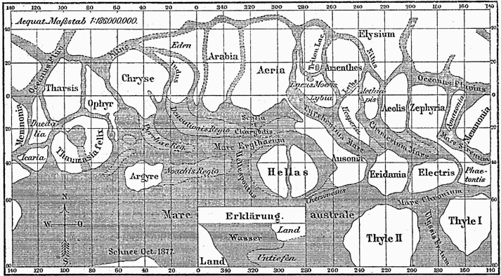

During Mars's "Great Opposition" of 1877, Schiaparelli observed a dense network of linear structures on the surface of Mars which he called "canali" in Italian, meaning "channels" but mistranslated as "canals". While the latter term indicates an artificial construction, the former indicates the connotation that it can also be a natural configuration of the land. From this incorrect translation, various assumptions about life on Mars derived, as the "canals" of Mars soon became famous, giving rise to waves of hypotheses, speculation, and folklore about the possibility of intelligent life on Mars, the Martians.
In his book Life on Mars, Schiaparelli wrote: "Rather than true channels in a form familiar to us, we must imagine depressions in the soil that are not very deep, extended in a straight direction for thousands of miles, over a width of 100, 200 kilometers and maybe more. I have already pointed out that, in the absence of rain on Mars, these channels are probably the main mechanism by which the water (and with it organic life) can spread on the dry surface of the planet.">>
http://apod.nasa.gov/apod/ap091129.html
Layers in a crater in the
Schiaparelli basin as seen by MGS.


Layers in Monument Valley. These are accepted as being formed, at least in part, by water deposition.
Since Mars contains similar layers, water remains as a major cause of layering on Mars.
Art Neuendorffer
-
orin stepanek
- Plutopian
- Posts: 8200
- Joined: Wed Jul 27, 2005 3:41 pm
- Location: Nebraska
Post
by orin stepanek » Sun Nov 29, 2009 5:10 pm
It looks like terracing on Mars. 8) Soil conservation by the Martians?

Orin
Orin
Smile today; tomorrow's another day!
-
bdx
- Asternaut
- Posts: 6
- Joined: Sun Nov 29, 2009 7:42 pm
Post
by bdx » Sun Nov 29, 2009 7:52 pm
I look at the ABOD every day and have for years now. This is one of my favorites. Glad to have a chance to discuss apod pics.
My question, which I asked through one of the original picture submitting experts to no avail, is just what is the football shaped object at the bottom of the "lake" where the white sand "beach" arrow like pointer is pointing to it.
I hope my description is ok.
BDX
-
rstevenson
- Quis custodiet ipsos custodes?
- Posts: 2705
- Joined: Fri Mar 28, 2008 1:24 pm
- Location: Halifax, NS, Canada
Post
by rstevenson » Mon Nov 30, 2009 1:14 pm
bdx wrote:... just what is the football shaped object at the bottom of the "lake" where the white sand "beach" arrow like pointer is pointing to it.
Everything in the picturre is either rock or sand. I can't tell for sure what you're referring to, but if you mean the dark rounded blob immediately to the bottom-left of the largest chunk of white, then that looks like a sand dune, roughly 100 meters in length, if my sense of the scale of the picture is right.
Rob
-
bdx
- Asternaut
- Posts: 6
- Joined: Sun Nov 29, 2009 7:42 pm
Post
by bdx » Mon Nov 30, 2009 5:41 pm
Rob,
Yes, you might be right. On further enlargement it kind of looks that way, but it sure is different from all else in the photo -that's why it caught my eye.
BDX
-
neufer
- Vacationer at Tralfamadore
- Posts: 18805
- Joined: Mon Jan 21, 2008 1:57 pm
- Location: Alexandria, Virginia
Post
by neufer » Mon Nov 30, 2009 10:37 pm
http://earthobservatory.nasa.gov/IOTD/view.php?id=41425 wrote:
<<This astronaut photograph features one of the largest of a series of ten mostly fresh water lakes in the Ounianga Basin in the heart of the Sahara Desert of northeastern Chad. The lakes are remnants of a single large lake, probably tens of kilometers long, that once occupied this remote area approximately 14,800 to 5,500 years ago. As the climate dried out during the subsequent millennia, the lake shrank, and large, wind-driven sand dunes invaded the original depression, dividing it into several smaller basins.
The area shown in this image is approximately 11 by 9 kilometers. The lakes’ dark surfaces are almost completely segregated by linear, orange sand dunes that stream into the depression from the northeast. The almost-year-round northeast winds and cloudless skies make for very high evaporation rates; an evaporation rate of more than 6 meters per year has been measured in one of the nearby lakes. Despite this, only one of the ten lakes is saline.
The reason for the apparent paradox—fresh water lakes in the heart of the desert—is that fresh water from a very large aquifer reaches the surface in the Ounianga Depression. The aquifer is large enough to keep supplying the small lakes with water despite the high evaporation rate. Mats of floating reeds also reduce the evaporation in places. The lakes form a hydrological system that is unique in the Sahara Desert.
The aquifer was charged with fresh water and the original lake evolved during the African Humid Period (about 14,800 to 5,500 years ago), when the West African summer monsoon was stronger than it is today. Associated southerly winds brought Atlantic moisture well north of modern limits, producing sufficient rainfall in the central Sahara to foster an almost complete savanna vegetation cover.
Pollen data from lake sediments of the original 50-meter-deep Ounianga Lake suggest to scientists that a mild tropical climate and a wooded grassland/savanna ecosystem existed in the region. Ferns grew in the stream floodplains. The same vegetation groups are now only encountered 300 kilometers farther south. Even shrubs that now occur only on the very high, cool summits (above 2,900 meters) of the Tibesti Mountains have been found in the Ounianga Lake sediments.>>
http://www.maplandia.com/chad/borkou-en ... nga-kebir/
http://travel.webshots.com/photo/201683 ... 1887paqguzArt Neuendorffer


