
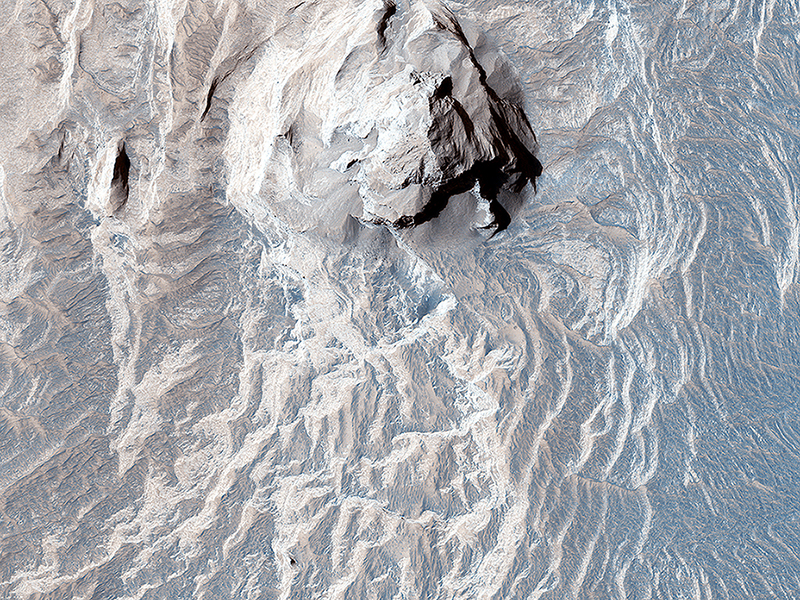
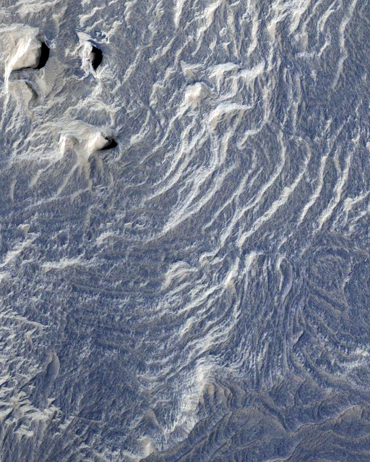
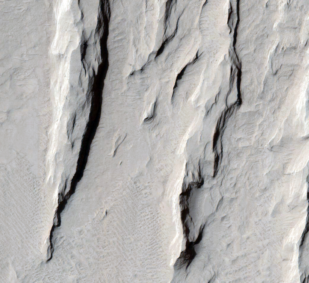
Elizabeth Silber, Livio Tornabene, and Kayle Hansen wrote:Light-Toned Layers in Tithonium Chasma (ESP_041886_1755) (HiClip)
Tithonium Chasma is a part of Valles Marineris, the largest canyon in the Solar System. If Valles Marineris was located on Earth, at more than 4,000 kilometers long and 200 kilometers wide, it would span across almost the entire United States. Tithonium Chasma is approximately 800 kilometers long. A “chasma”, as defined by the International Astronomical Union, is an elongate, steep-sided depression.
The walls of canyons often contain bedrock exposing numerous layers. In some regions, light-toned layered deposits erode faster than the darker-toned ones. The layered deposits in the canyons are of great interest to scientists, as these exposures may shed light on past water activity on Mars. The CRISM instrument on MRO indicates the presence of sulfates, hydrated sulfates, and iron oxides in Tithonium Chasma. Because sulfates generally form from water, the light-toned sulfate rich deposits in the canyons may contain traces of ancient life.
The mid-section of this image is an excellent example of the numerous layered deposits, known as interior layered deposits. The exact nature of their formation is still unclear. However, some layered regions display parallelism between strata while other regions are more chaotic, possibly due to past tectonic activity. Lobe-shaped deposits are associated with depositional morphologies, considered indicative of possible periglacial activity.
Overall, the morphological and lithological features we see today are the result of numerous geological processes, indicating that Mars experienced a diverse and more active geological past.
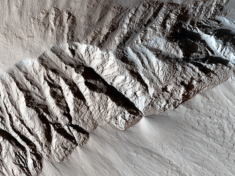
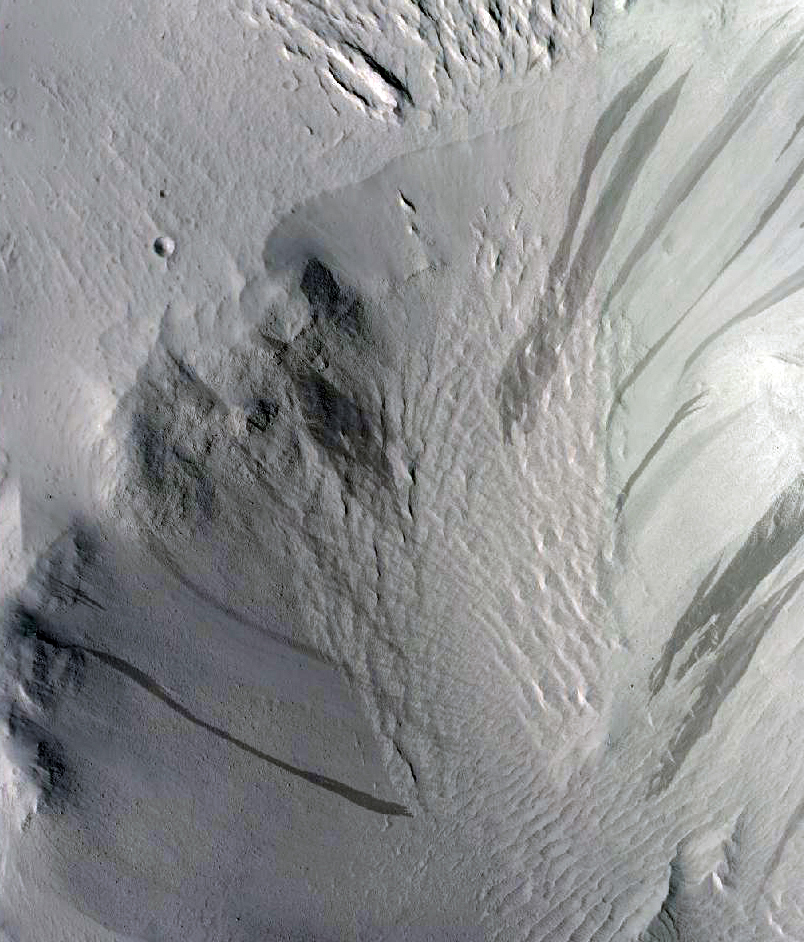
Kayle Hansen, Livio Tornabene, and Elizabeth Silber wrote:Ridge and Talus in Lycus Sulci (ESP_041901_2065) (HiClip)
This image nicely captures several influential geologic processes that have shaped the landscape of Lycus Sulci.
Our observation covers an area of about 7.5 by 5.4 kilometers in Lycus Sulci, located just to the northwest of Olympus Mons in the Tharsis region of Mars. “Sulci” is a Latin term meaning “furrow” or “groove.” In this case, Lycus Sulci is a region comprised of a series of depressions and ridges.
Like most of the Tharsis region, Lycus Sulci exhibits thick deposits of light-toned Martian dust; the slopes on ridges in this region feature abundant streaks. These streaks are long, thin dark-toned features. They appear when the superficial light-tone fine-grained materials (i.e., Martian dust) suddenly move down slope and expose the darker underlying volcanic surfaces. Repeat imaging shows that dust streaks are consistently dark when they are initially formed and become lighter over time. This is due to the steady deposition of dust from the atmosphere. Slope streaks are also visible along the slopes of ridges and shallow depressions.
Two ridges here exhibit partially exposed bedrock. These outcrops are interpreted to still have abundant coatings and dust, obscuring the underlying bedrock. This interpretation is based on the lack of bluish color for volcanic bedrock from the infrared-red-blue swath of our camera, and consistent with the homogenous tannish color we see throughout the same swath. It’s possible that the ridges here and throughout the Lycus Sulci region formed via volcanic and tectonic processes, which have been further sculpted by wind erosion and other mass wasting processes. For example, talus slopes, which appear as fine-grained fans or conical-shaped deposits, originate from the steepest portions of the ridges. These form when the rocks or deposits on the steepest slopes of a ridge fail under the influence of Martian gravity and their own mass, causing an avalanche of these materials, which then accumulate downslope.
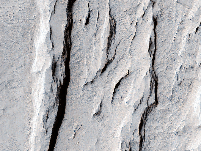
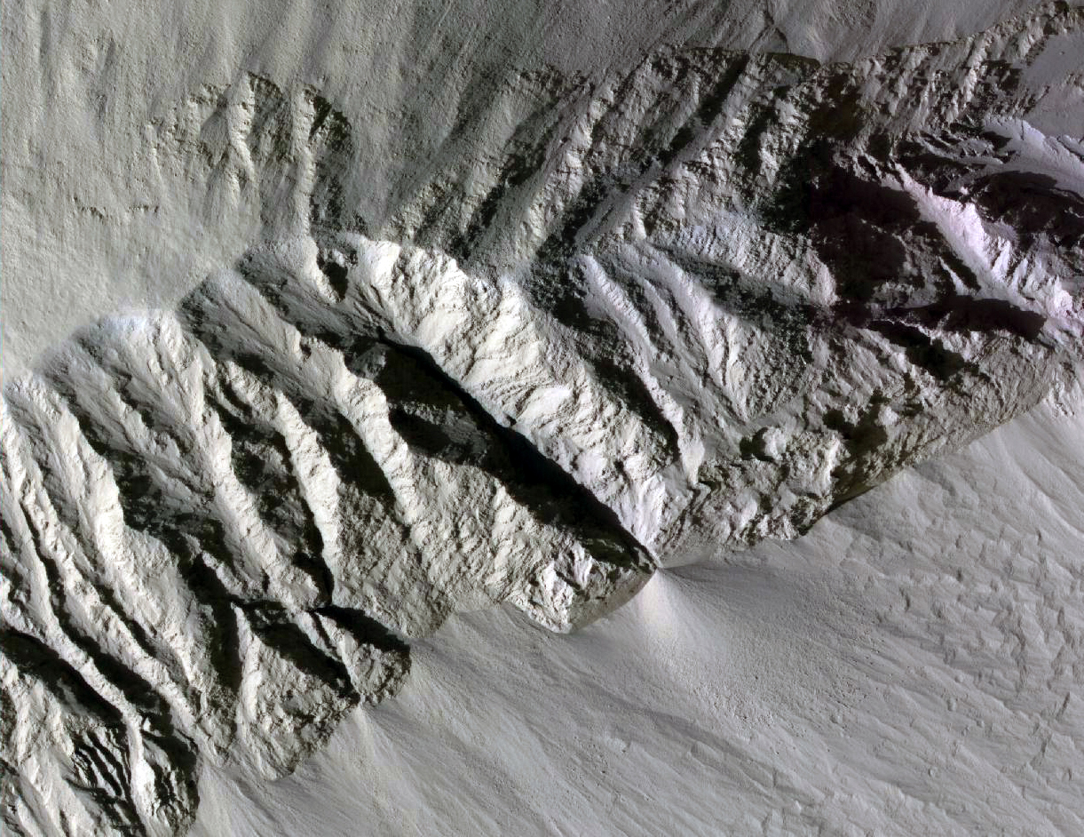
Elizabeth Silber, Livio Tornabene, and Kayle Hansen wrote:Yardang-Sculpted Deposits from Apollonaris Patera (ESP_041929_1675) (HiClip)
We see here a terrain with an incredible morphologic dichotomy: a relatively smooth region that transitions into sharp ridges. These ridges, aligned in the nearly same direction, are called yardangs. Yardangs are not unique to Mars. Many yardangs can be found on Earth, in very dry regions with strong prevailing winds.
Yardangs are formed when a surface that is composed of materials of differing strengths (i.e., of both harder and softer materials) is shaped by the abrasive action of sand and dust carried by the wind. In this case, and given the proximity of the Apollonaris Patera volcanic center, we think that these wind-carved deposits are comprised of volcanic ash and pyroclastics that erupted from Apollonaris when it was last active in the not-too-distant geologic past.
Over time, the softer materials (likely volcanic ash) were eroded away, leaving behind the harder materials in the form of elongated ridges that are parallel to the direction of the prevailing wind. The end result is a stunning, out-of-this-world display of yardangs, sculpted with the artistic chisel of the Martian wind.
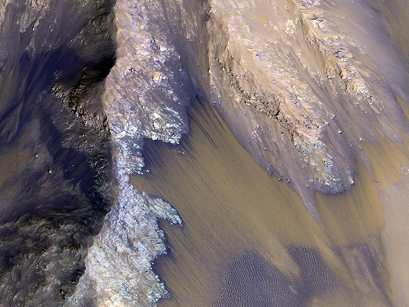
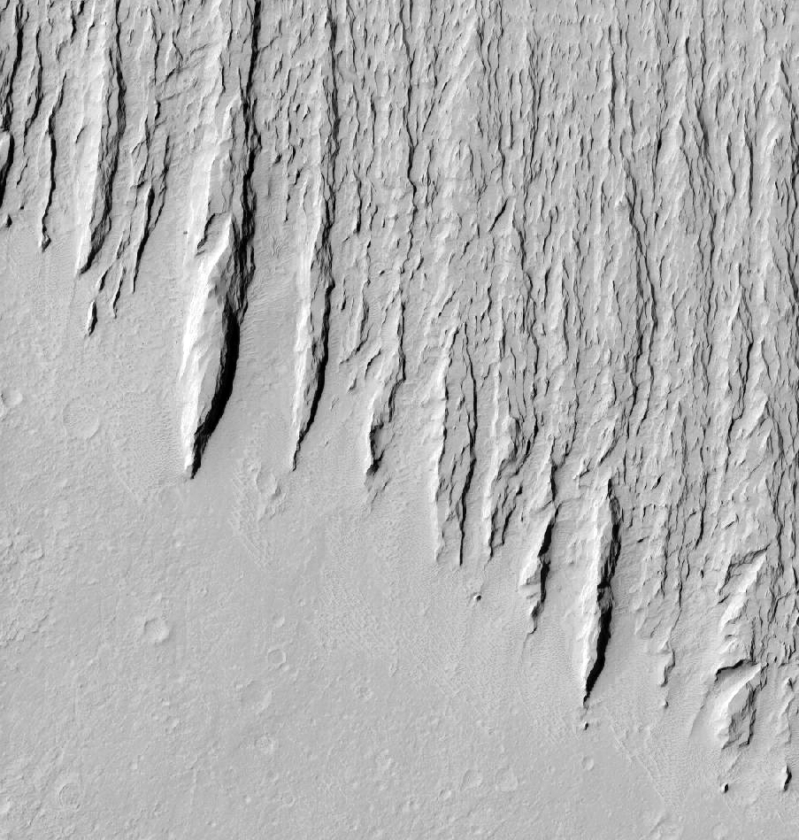
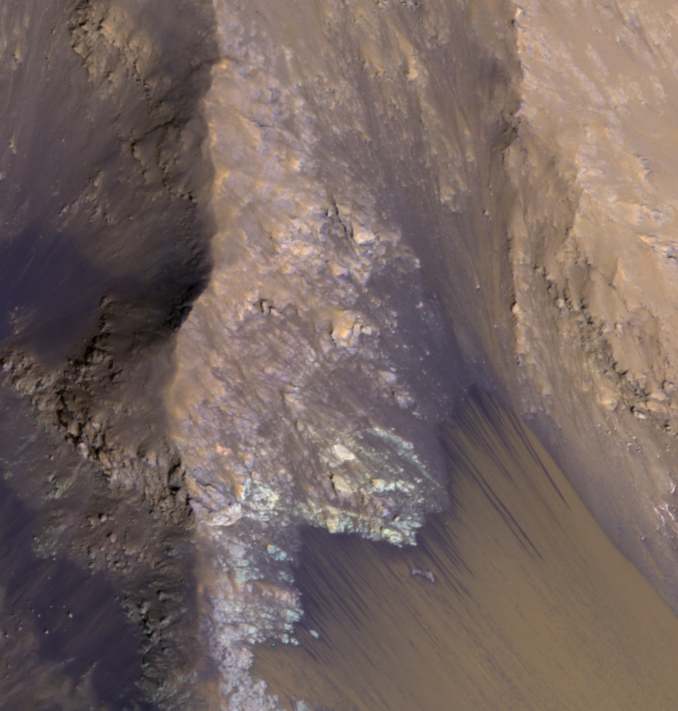
Alfred McEwen wrote:Seasonal Flows in Valles Marineris (ESP_042228_1670) (HiClip)
Mars Reconnaissance Orbiter launched 10 years ago! One of the many discoveries from this mission is that there are seasonal flows on some steep slopes, that have a set of characteristics consistent with shallow seeps of salty water. They are called recurring slope lineae because they fade and disappear during cold seasons and reappear in warm seasons, repeating this pattern every Martian year.
The flows in this image, in a part of Coprates Chasma, are on a north-facing slope so they are active now, in northern spring. The flows emanate from the relatively bright bedrock and flow onto sandy fans, where they are remarkably straight, following linear channels. Valles Marineris contains more of these flows than everywhere else on Mars combined, and they are always active although on changing slope aspects with season. Future human explorers (and settlers?) will need water to drink, grow food, produce oxygen to breathe, and to produce rocket fuel. Bringing all of that water from Earth would be extremely expensive, so using water on Mars is essential.
Although there is plenty of water ice at high latitudes, surviving the cold winters would be difficult. An equatorial source of water would be preferable, so Valles Marineris may be the best destination. However, the chemistry of this water must be understood before betting any lives on it.
Credit: NASA/JPL/University of Arizona
<< Previous HiRISE Update