See new, spectacular, or mysterious sky images.
-
bystander
- Apathetic Retiree
- Posts: 21577
- Joined: Mon Aug 28, 2006 2:06 pm
- Location: Oklahoma
Post
by bystander » Wed Jan 30, 2019 4:50 pm
Week of 21 January 2019
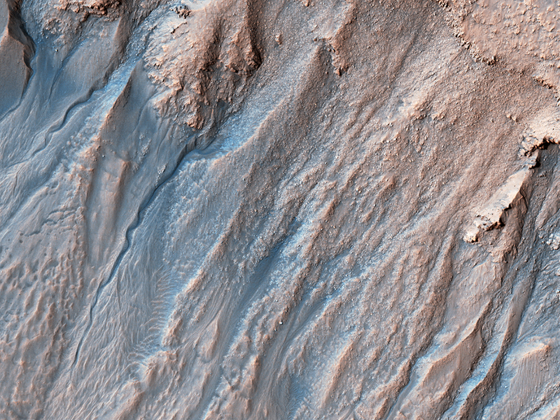
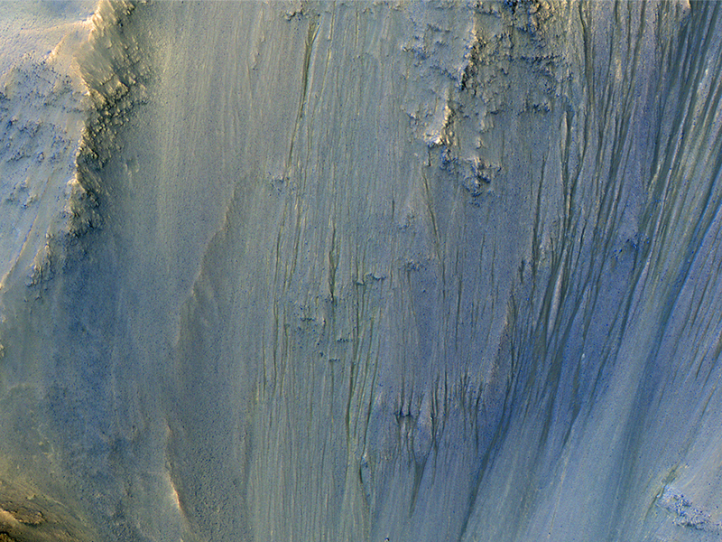
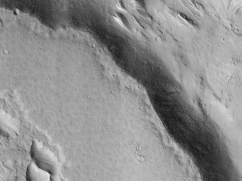
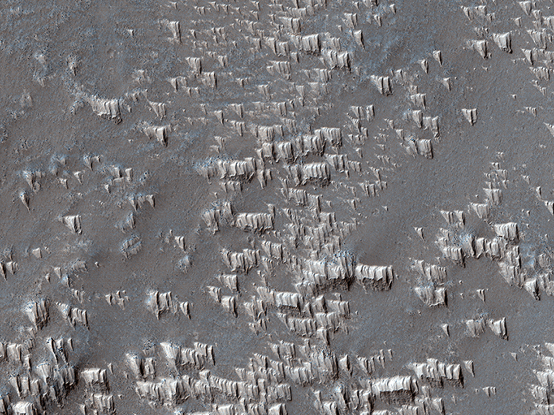
Ginny Gulick wrote:Multi-Elevation Gullies (ESP_057450_1410) (HiClip)
Gullies probably formed along the bouldery layers in the upper slopes of this unnamed crater within the last few million years. Gullies eroded these crater slopes and transported sediment downslope forming debris aprons multiple times.
These older apron surfaces were cut by numerous fractures running perpendicular to the slope. Subsequent episodes of gully activity eroded through these fractures and deposited new aprons.
On the floor of the crater are ridges with bouldery layers. These ridges may mark the furthest extent of glaciers that predate much of the original gully activity. Bright flows continue to form in these gullies seasonally.
In the upper gully regions, long shadows cast
by jagged outcrops allow scientists to determine the heights and depths of landforms by measuring the length of the shadows cast by the ridges onto the gully floor.
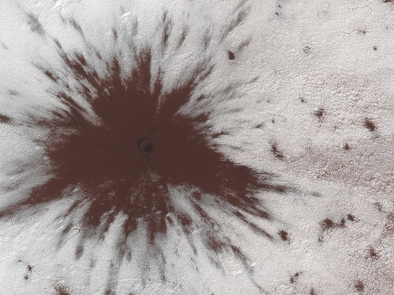
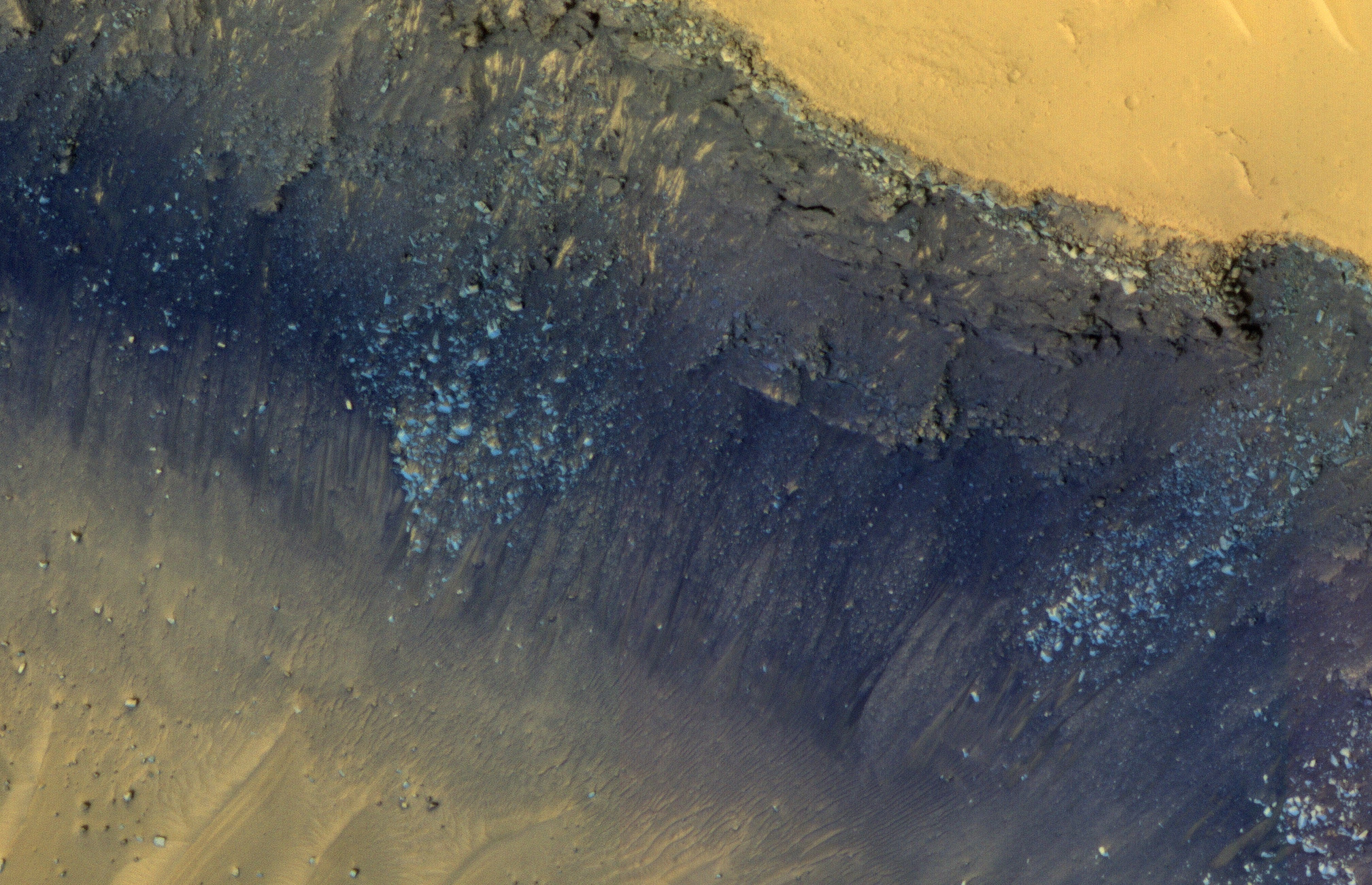
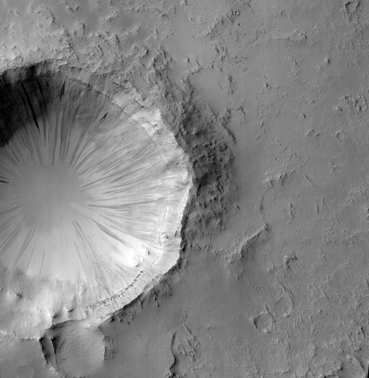
Ross A. Beyer wrote:Impact Near the South Pole (ESP_057152_0985) (HiClip)
This image shows a new impact crater that formed between July and September 2018. It’s notable because it occurred in the seasonal southern ice cap, and has apparently punched through it, creating a two-toned blast pattern.
The impact hit on the ice layer, and the tones of the blast pattern tell us the sequence. When an impactor hits the ground, there is a tremendous amount of force like an explosion. The larger, lighter-colored blast pattern could be the result of scouring by winds from the impact shockwave. The darker-colored inner blast pattern is because the impactor penetrated the thin ice layer, excavated the dark sand underneath, and threw it out in all directions on top of the layer.
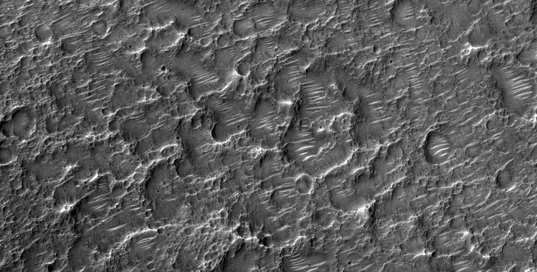
Eric Pilles, Matthew Bourassa, Shannon Hibbard and Livio Tornabene wrote:Cross-Section of a Complex Crater (ESP_058057_1465) (HiClip)
This image shows a cross-section of a complex crater in Terra Cimmeria.
Starting in the center, we see a series of peaks
with exposed bedrock. These peaks formed during the impact event when material that was originally several kilometers below the surface was uplifted and exposed. The impact also melted the rocks. This eventually cooled, forming the
pitted materials that coat the crater floor around the uplift.
The rim of the crater was unstable, and collapsed inwards to
form terraces, and we see additional pitted materials between the terraces and the rim. Just outside the crater we can see
dark-toned material that was excavated and thrown out after the impact.
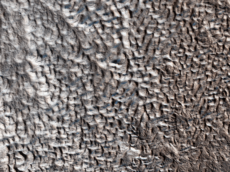
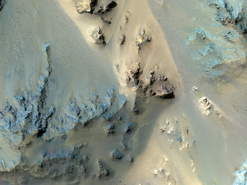
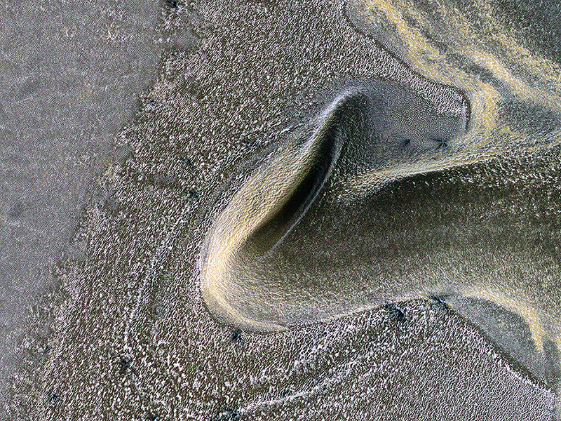
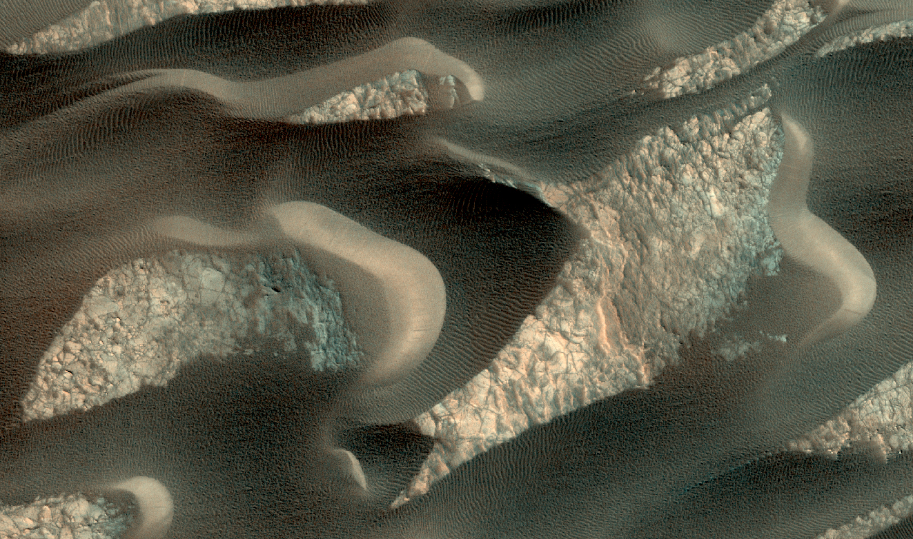
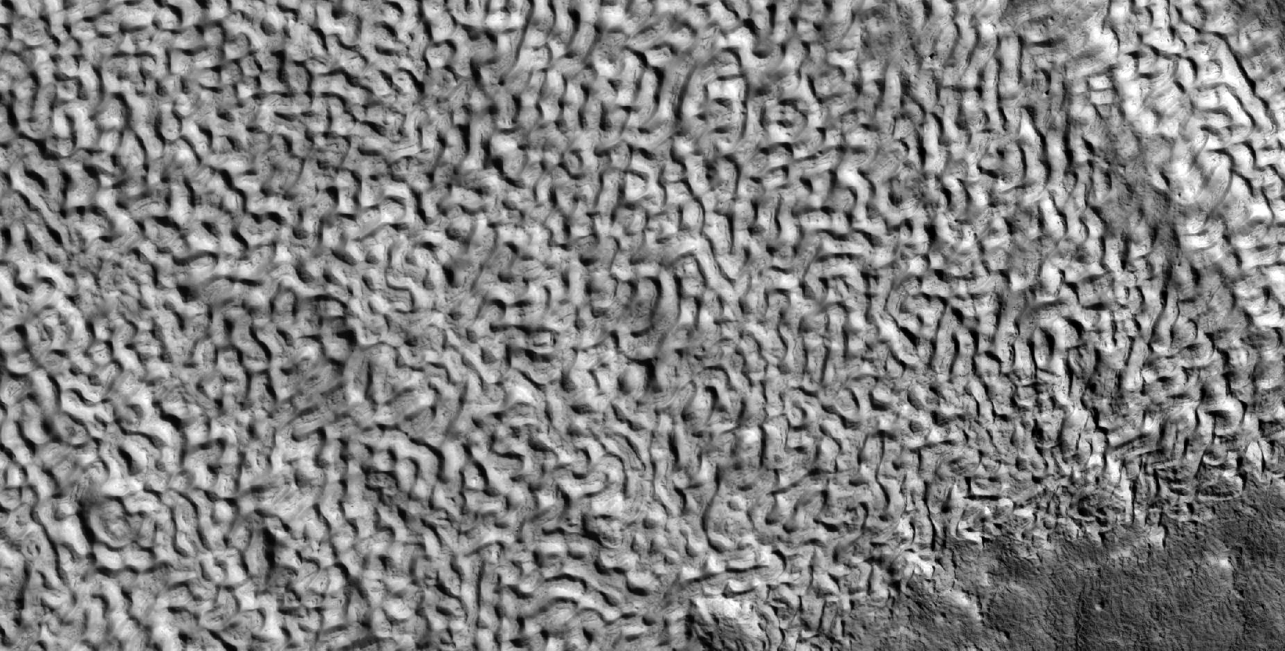
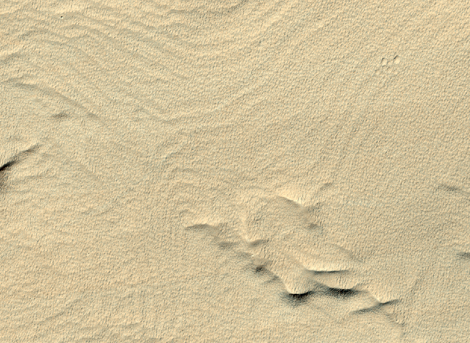
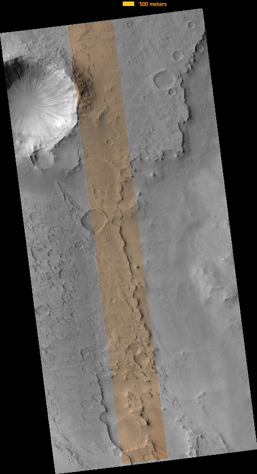
Nicole Baugh wrote:A First Look at Dunes (ESP_057903_1390) (HiClip)
This image shows us a cross-section of a dune field. Dune shape depends on several factors, including the amount of sand present and the local wind directions. This dune field displays several distinct dune morphologies.
We see both individual
barchan-like dunes and more complex dune shapes. The dunes are arranged in a linear fashion at the northern extent of the field, first in areas with lots of sand, and then with relatively sand-free patches in between dune crests. HiRISE has observed dune activity in
other similar fields, but this is our first image over this group of dunes.
A second image is needed to determine if these dunes are also evolving and moving.
Credit: NASA/JPL-Caltech/University of Arizona
<< Previous HiRISE Update
Know the quiet place within your heart and touch the rainbow of possibility; be
alive to the gentle breeze of communication, and please stop being such a jerk. — Garrison Keillor
-
bystander
- Apathetic Retiree
- Posts: 21577
- Joined: Mon Aug 28, 2006 2:06 pm
- Location: Oklahoma
Post
by bystander » Wed Feb 06, 2019 6:59 pm
Week of 04 February 2019
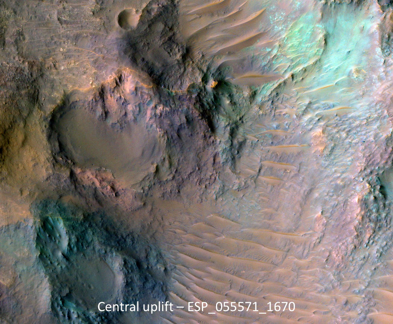
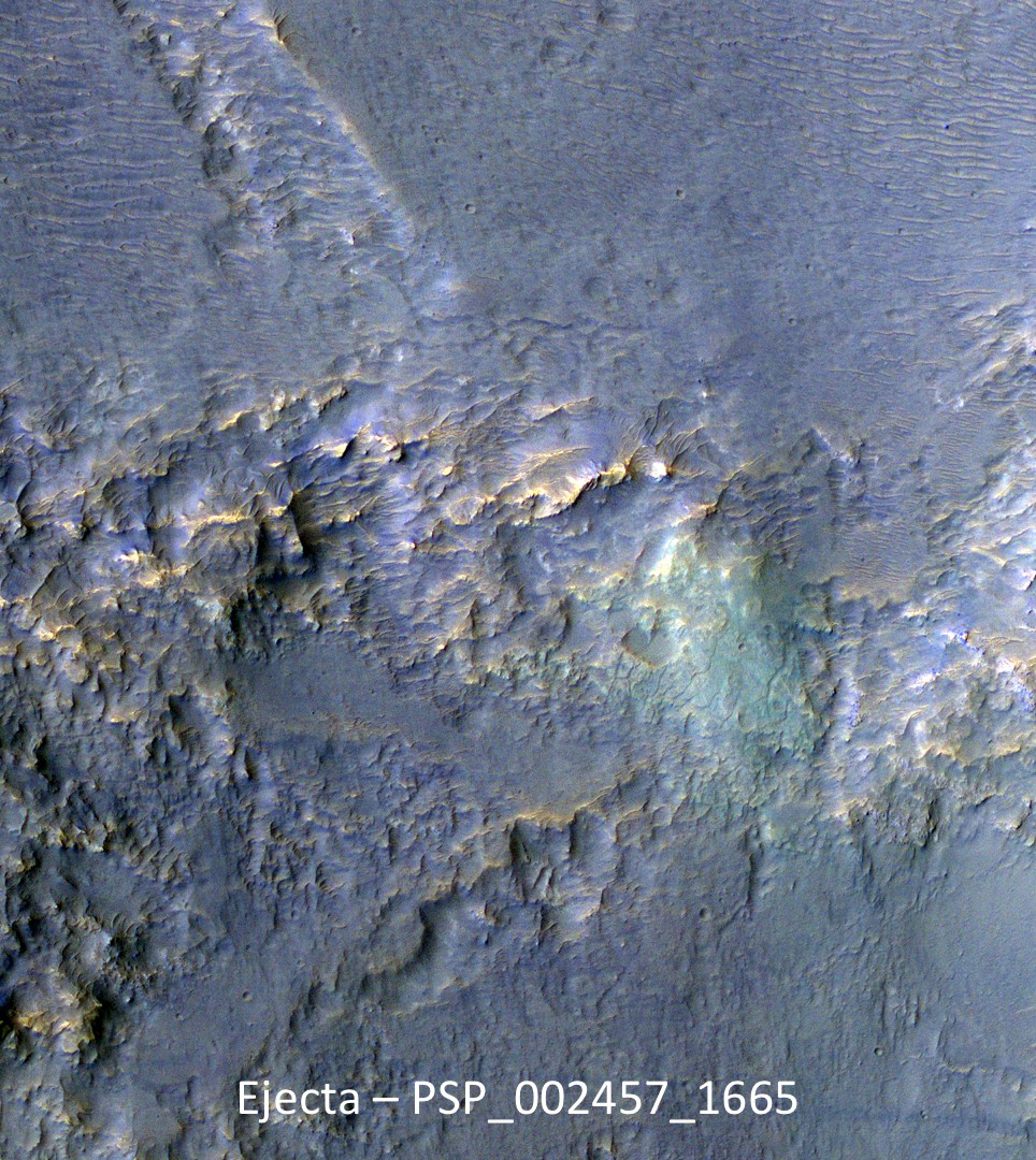
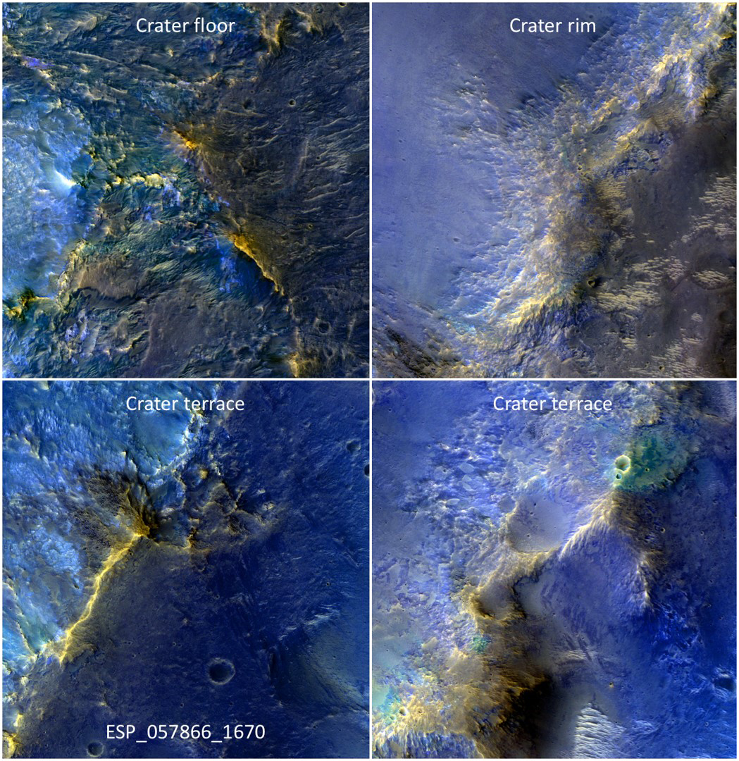
Eric Pilles and Livio Tornabene wrote:Exposing the Rock in Impact Craters (ESP_057866_1670) (HiClip)
In this complex crater (about 44-kilometers in diameter), we see bedrock in several locations from different depths in the crust.
The central uplift exposes large fragments of green-toned bedrock that possibly originated from several kilometers beneath the surface.
To the south of the crater, we see more of this bedrock along with material that was excavated and thrown out
after the impact. In craters of this size, the rim is unstable and collapses inwards forming terraces, which occasionally exposes more bedrock that would have originated from close to the surface than the rocks exposed within the uplift itself. Central uplifts have better exposures of bedrock, but in this example the terraces steal the show, displaying beautiful
green- and light-toned bedrock at multiple locations.
This is a stereo pair with
ESP_057932_1670.
Susan Conway wrote:A Dune Field near Nili Patera (ESP_057071_1890) (HiClip)
In this image many sand dunes are visible. They have an elongated crescent form and are called “barchan dunes.” They are formed by the continuous action of the wind, blowing in the same direction, giving this particular shape.
The orientation of these dunes tell us that the prevailing wind blows from the right to the left (east to west). The wind is continuously moving sand grains up the longer dune slope, towards the top. The small ripples on the slope are caused by this movement. When the sand grains arrive at the top, they fall down the steeper and shorter slope, which as a consequence, has no ripples. It is this gradual sand movement that causes the dunes to slowly move over time.
Candy Hansen wrote:Wind Flow (ESP_057930_1720) (HiClip)
The atmospheric pressure on Earth at sea level is about 1 bar. On Mars, the pressure is 6 to 10 millibars, or 1/100th that of our planet. But even in this atmosphere, wind still flows around obstacles.
In this image the ripples in the sand tell us which way the wind was moving and how it was diverted around these rock formations.
This is a stereo pair with
ESP_057864_1720.
Credit: NASA/JPL-Caltech/University of Arizona
Know the quiet place within your heart and touch the rainbow of possibility; be
alive to the gentle breeze of communication, and please stop being such a jerk. — Garrison Keillor
-
bystander
- Apathetic Retiree
- Posts: 21577
- Joined: Mon Aug 28, 2006 2:06 pm
- Location: Oklahoma
Post
by bystander » Tue Mar 05, 2019 8:14 pm
Week of 18 February 2019
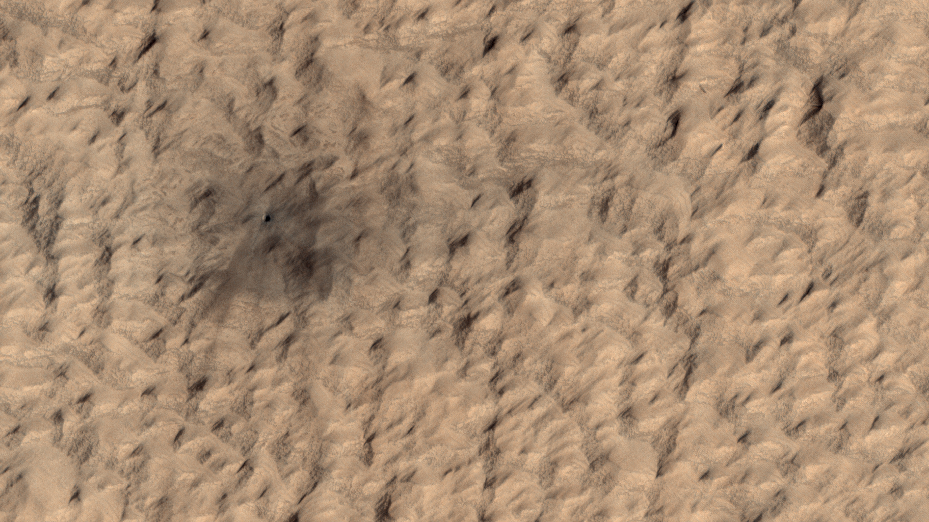
Colin Dundas wrote:Following the Tracks (ESP_058427_1080) (HiClip)
Dust devils on Mars often create long, dark markings where they pull a thin coat of dust off the surface. This image shows a cluster of these tracks on the flat ground below the south polar layered deposits, but none on the layers themselves.
This tells us that either dust devils do not cross the layers, or they do not leave a track there. There are several possible reasons for this. For instance, the dust might be thick enough that the vortex of the dust devil doesn’t expose darker material from underneath the surface.
Eric Pilles, Matthew Bourassa, Shannon Hibbard and Livio Tornabene wrote:Almost Like Water (ESP_057978_1875) (HiClip)
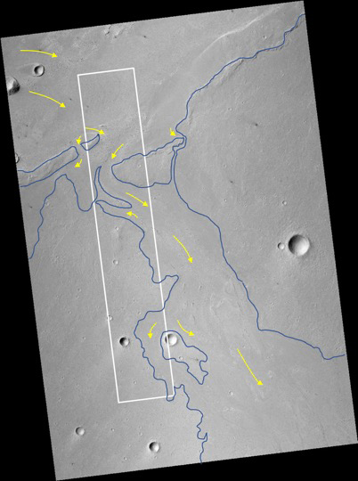
This image in Athabasca Valles shows lava flows originating from Elysium Mons to the northwest. A Context Camera image shows the lava flowed from the northwest to the southeast,
diverting around obstacles as it settled. (The flow is outlined in blue with the flow direction shown in yellow, and the approximate location of the HiRISE image is represented by a white rectangle.)
The lava appears to have flowed smoothly around obstructions, almost like water,
forming streamlined islands. In the southern part of this image, a branch of the flow diverts around a small crater, and eventually rejoins the main part of the flow. Irregular-shaped ring structures appear on the northern end and are related to the
volcanic activity that formed the flows.
We also see a dense cluster of secondary craters that formed when material ejected from Corinto Crater (to the northwest) impacted the surface at high speed. At full-resolution, this terrain has the distinctive appearance of a field of
numerous, small and closely-spaced craters.
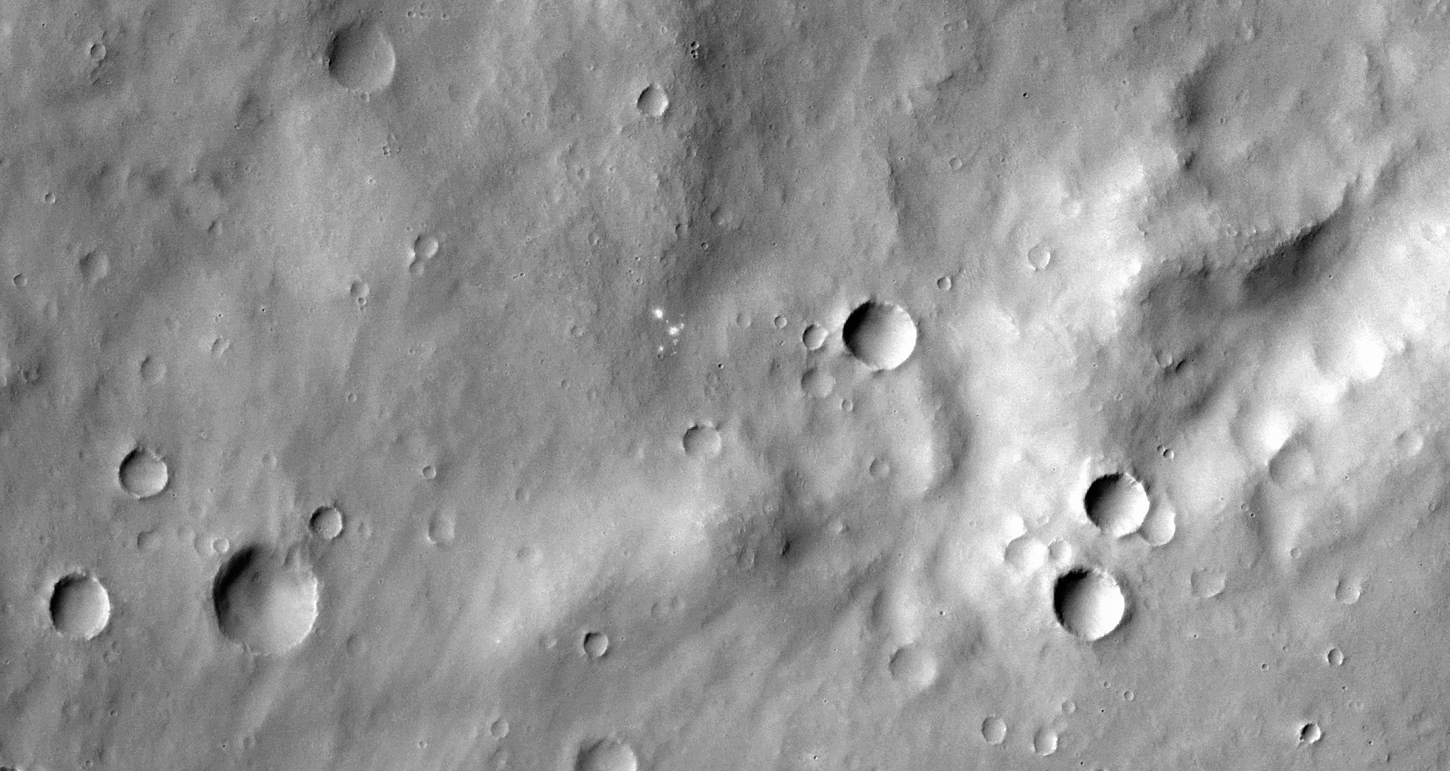
Matthew Bourassa, Shannon Hibbard, Eric Pilles and Livio Tornabene wrote:A Recent Impact Site in Noachis Terra (ESP_057984_1490) (HiClip)
This image shows a recent impact in Noachis Terra in the southern mid-latitudes of Mars. The impact occurred in dark-toned ejecta material from a degraded, 60-kilometer crater to the south.
Rather than a single impact crater, we see multiple impacts like a shotgun blast. This suggests that the impactor broke up in the atmosphere on entry. Although the atmosphere of Mars is thinner than Earth’s, it still has the capacity to break up small impactors, especially ones comprised of weaker materials, like a stony meteoroid versus a iron-nickel one.
Our image depicts
21 distinctive craters ranging in size from 1 to 7 meters in diameter. They are distributed over an area that spans about 305 meters. Most observed recent impacts expose darker-toned materials
underlying bright dusty surfaces. However, this impact does the opposite, showing us lighter-toned materials that lie beneath a darker colored surface.
The impact was initially discovered in a
2016 Context Camera image, and was not seen in a
2009 picture. This implies that the impact may be only two years old, but certainly no more than nine years.
This is a stereo pair with
ESP_049175_1490.
Credit: NASA/JPL-Caltech/University of Arizona
Know the quiet place within your heart and touch the rainbow of possibility; be
alive to the gentle breeze of communication, and please stop being such a jerk. — Garrison Keillor
-
bystander
- Apathetic Retiree
- Posts: 21577
- Joined: Mon Aug 28, 2006 2:06 pm
- Location: Oklahoma
Post
by bystander » Tue Mar 05, 2019 8:30 pm
Week of 04 March 2019
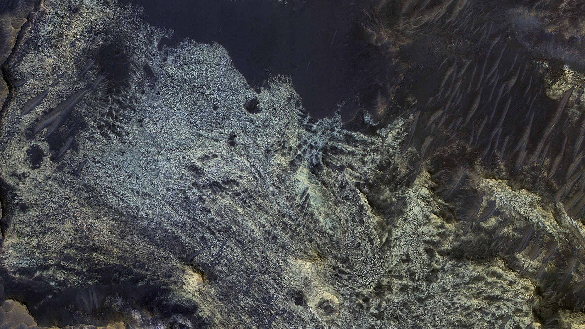
Shannon Hibbard, Matt Bourassa, Eric Pilles and Livio Tornabene wrote:The Slow Charm of Brain Terrain (ESP_058008_2225)
You are staring at one of the unsolved mysteries on Mars. This surface texture of interconnected ridges and troughs, referred to as “brain terrain” is found throughout the mid-latitude regions of Mars. (This image is in Protonilus Mensae.)
This bizarrely textured terrain may be directly related to the water-ice that lies beneath the surface. One hypothesis is that when the buried water-ice sublimates (changes from a solid to a gas), it forms the
troughs in the ice. The formation of these features might be an active process that is slowly occurring since HiRISE has yet to detect significant changes in these terrains.
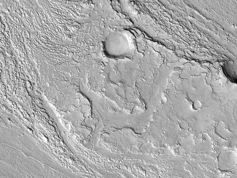
Susan Conway wrote:Gullies in Galle (ESP_058196_1280)
This image was taken of the hills that resulted from uplifted rocks due to an impact that formed the 230-kilometer diameter Galle Crater.
These hills form a segment of a circle known as a “peak ring” and this particular formation makes Galle Crater look like a “smiley face” from orbit.
Small gullies,
visible in the center of this image, have formed on the flanks of these hills and they have eroded back into the bedrock. The crater itself is probably billions of years old, yet these gullies are likely only hundreds of thousands of years old and may even be active today.
The small channels in these gullies are easily erased by the wind over long time periods, so we know these gullies must have been active recently.
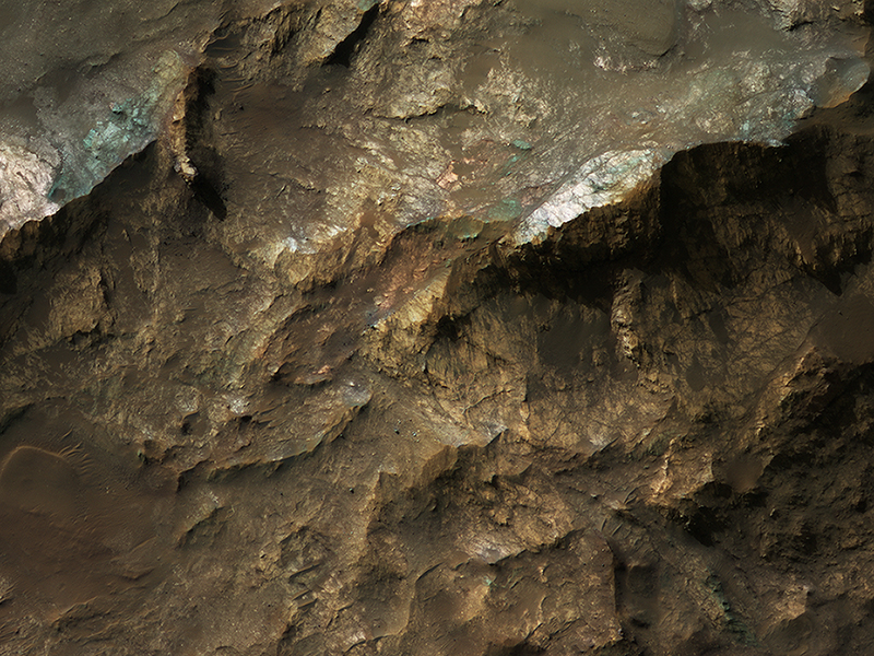
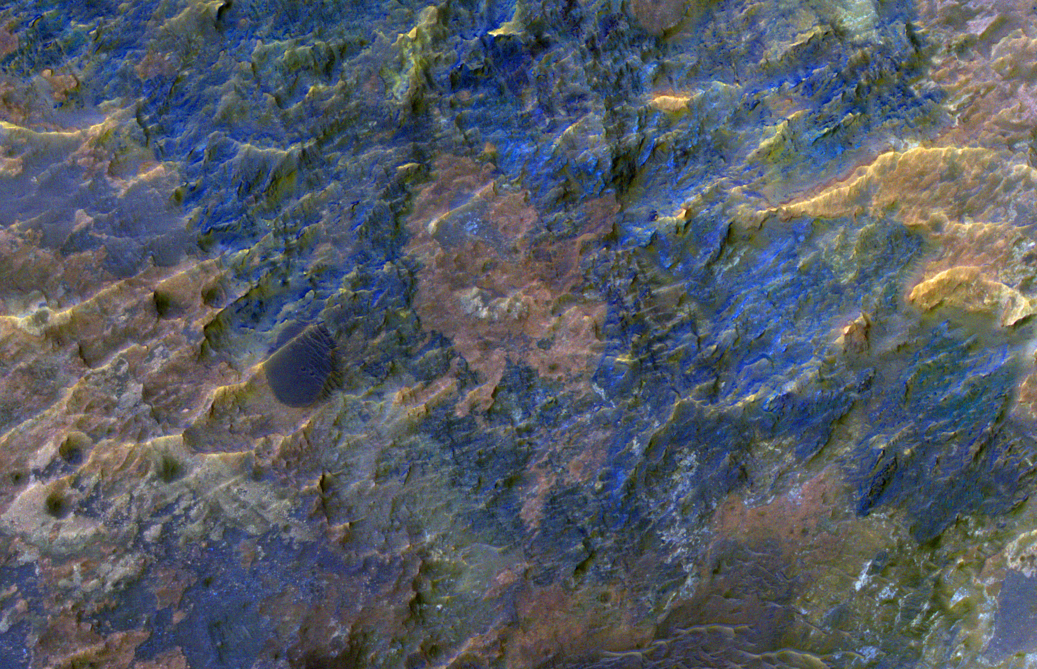
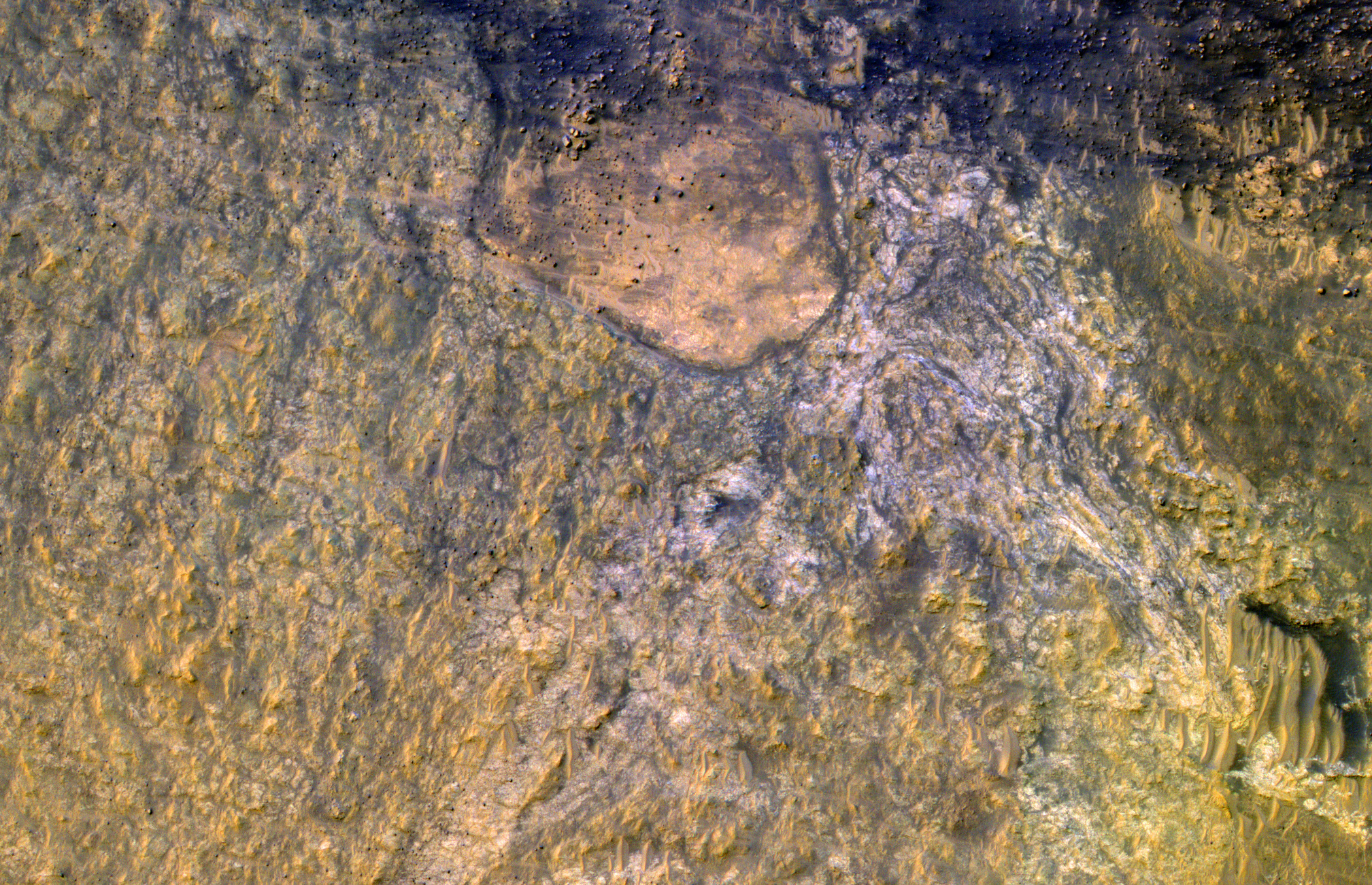
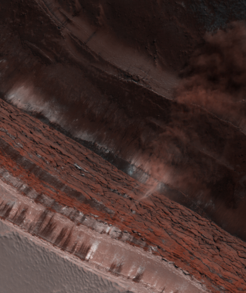
Alfred McEwen wrote:Colorful Impact Ejecta in Ladon Valles (ESP_058565_1620)
This image covers the western portion of a well-preserved (recent) impact crater in Ladon Basin. Ladon is filled by diverse materials including chemically-altered sediments and unaltered lava, so the impact event ejected and deposited a
wide range of elements.
This image is the first of a pair of images for stereo coverage, so check out the stereo anaglyph when completed.
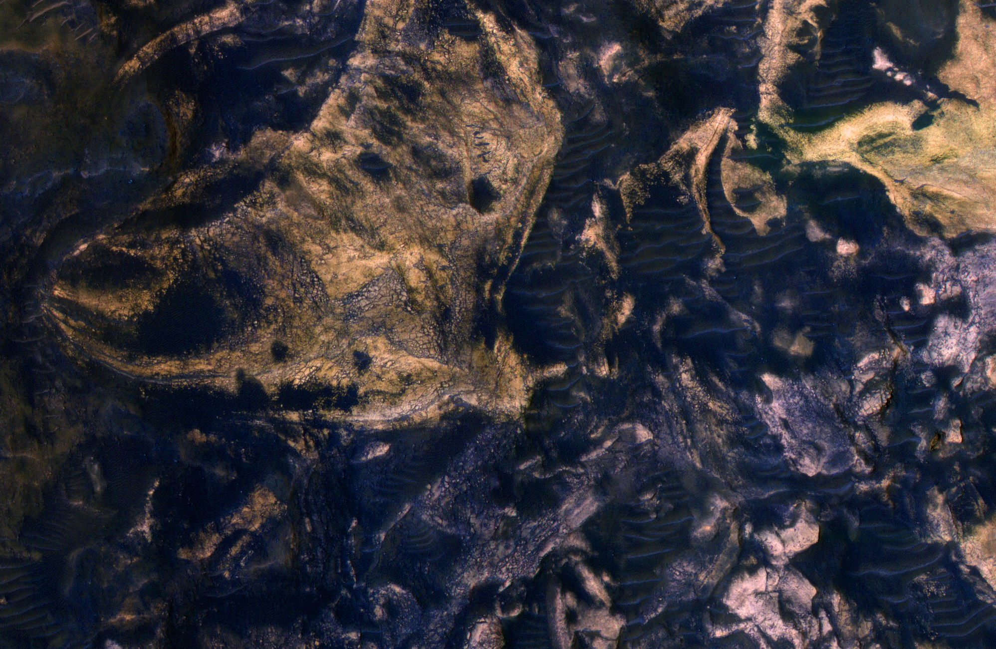
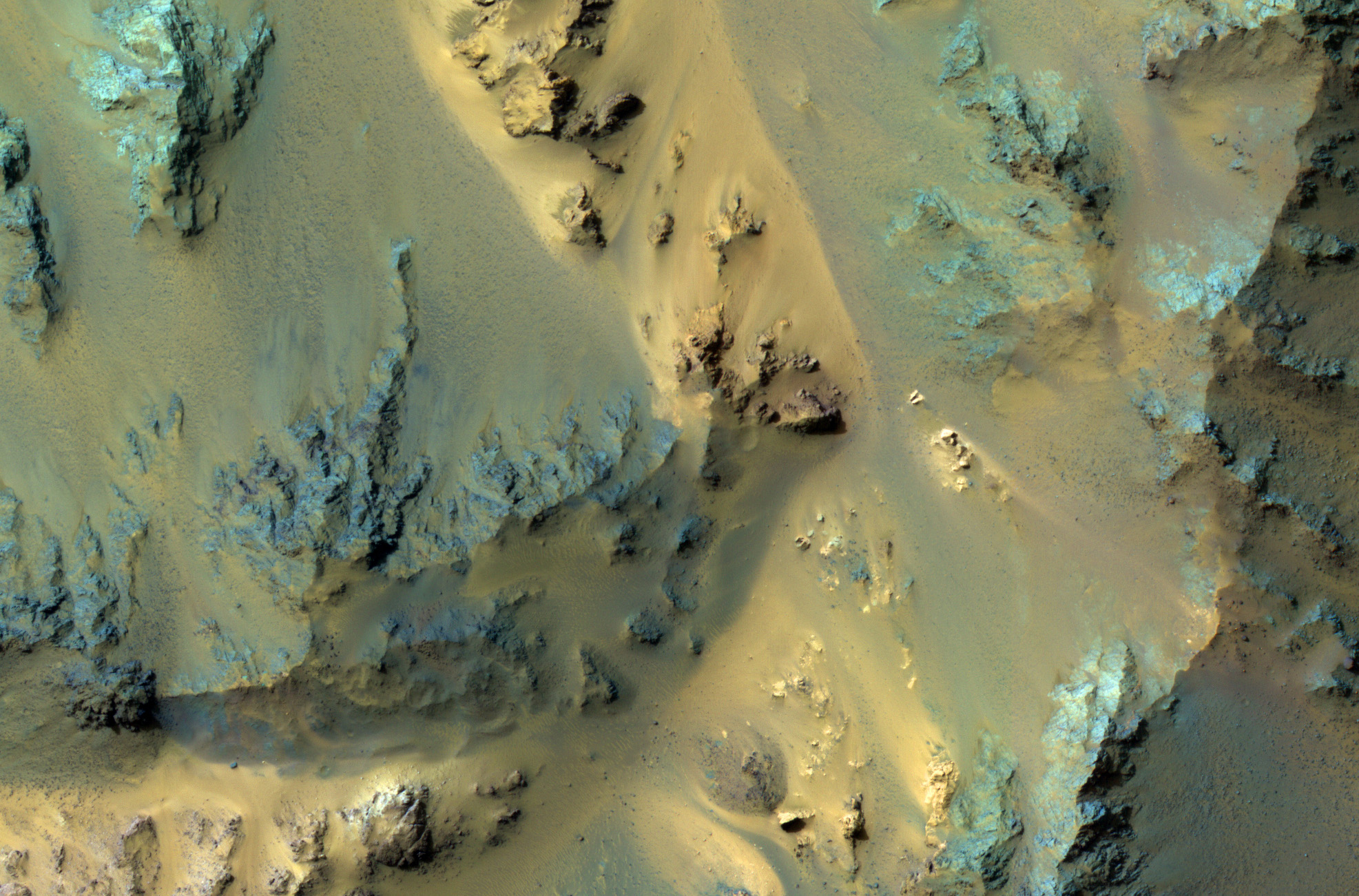
Catherine Weitz wrote:Colorful Mawrth Vallis (ESP_058749_2060)
Mawrth Vallis is a place on Mars that has fascinated scientists because of the clays and other hydrated minerals detected from orbit.
In this image, the enhanced black colors are most likely basaltic sands and rocks, while the green, yellow, and blue colors correspond to the different hydrated minerals.
This particular image was taken of a location in Mawrth Vallis that has a mineral called jarosite. Jarosite on Earth forms under wet, oxidizing, and acidic conditions. Another place on Mars where the Opportunity rover landed and explored also has jarosite.
This is a stereo pair with
ESP_058182_2060.
Credit: NASA/JPL-Caltech/University of Arizona
Know the quiet place within your heart and touch the rainbow of possibility; be
alive to the gentle breeze of communication, and please stop being such a jerk. — Garrison Keillor
-
bystander
- Apathetic Retiree
- Posts: 21577
- Joined: Mon Aug 28, 2006 2:06 pm
- Location: Oklahoma
Post
by bystander » Tue Mar 19, 2019 4:44 pm
Week of 18 March 2019
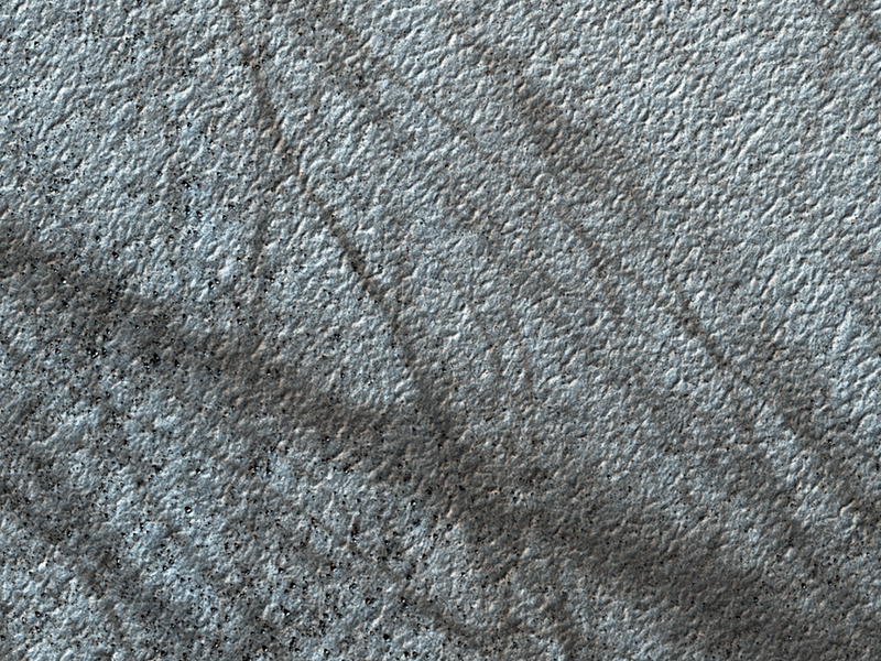
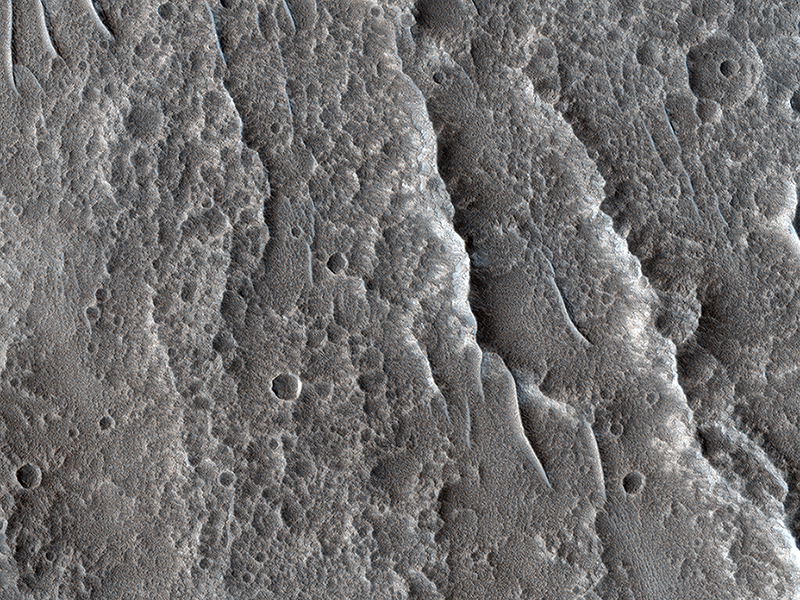
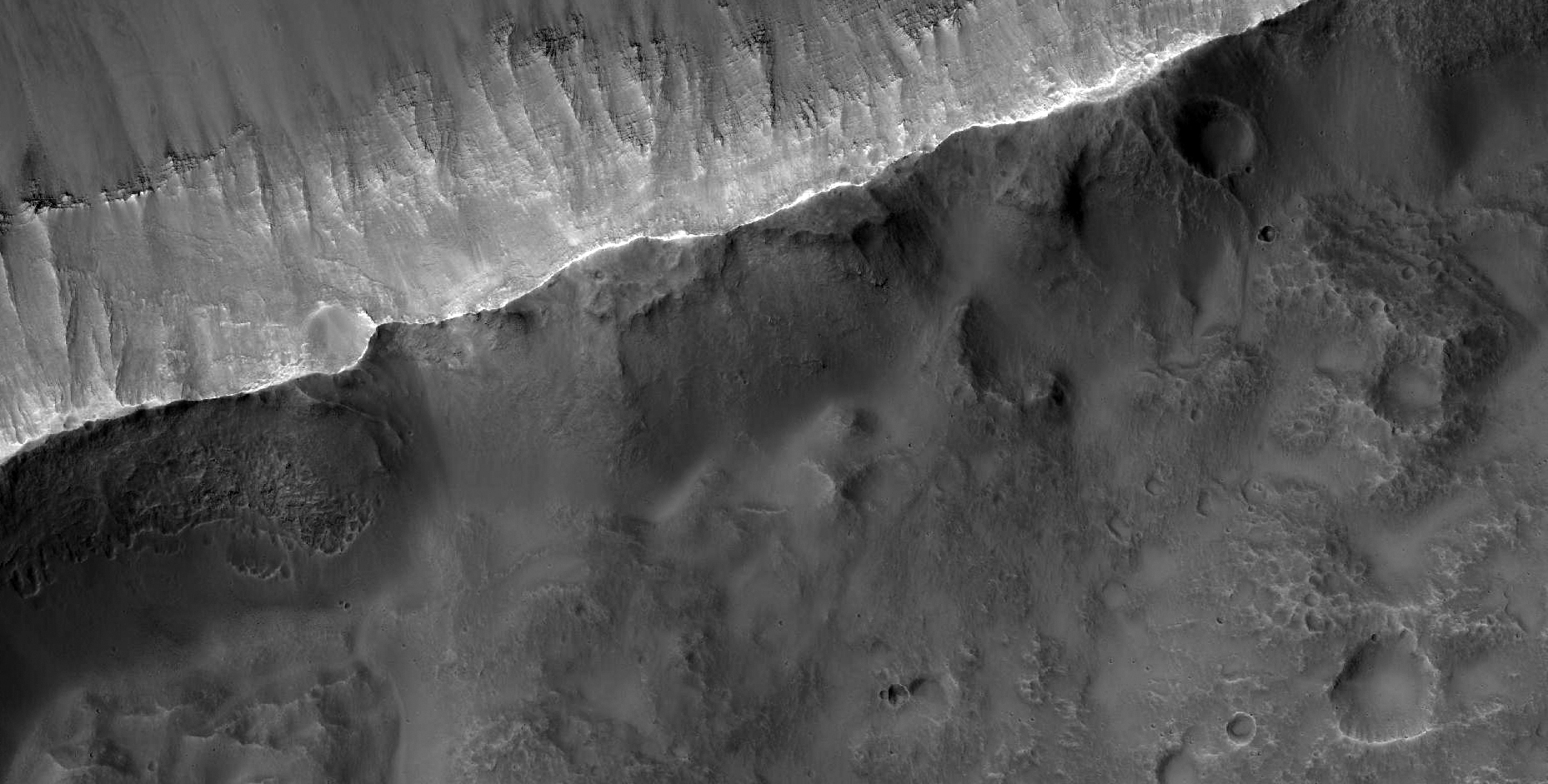
Colin Dundas wrote:Complex Gullies in a Crater (ESP_058399_1415) (HiClip)
Most gullies in the southern mid-latitudes are on south-facing slopes, which are the coldest and have the most frost in the winter. However, some occur on other slopes.
This image shows large gullies on both the pole- and equator-facing slopes. An important puzzle in Mars science is whether or not all of these gullies form in the same geologic eras and by the same processes.
If you have red/green glasses, be sure to check out
the anaglyph of this crater, which shows rugged topography!
This is a stereo pair with
ESP_057700_1415.
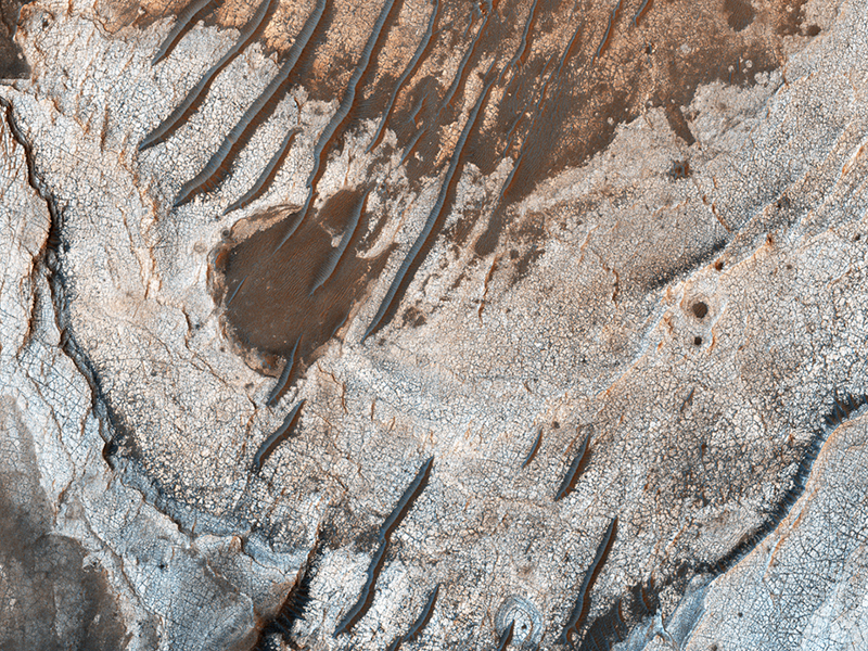
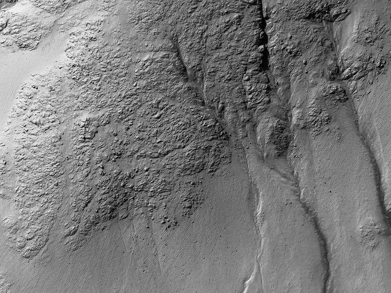
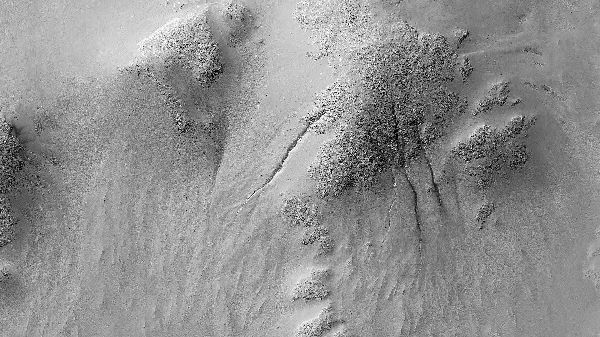
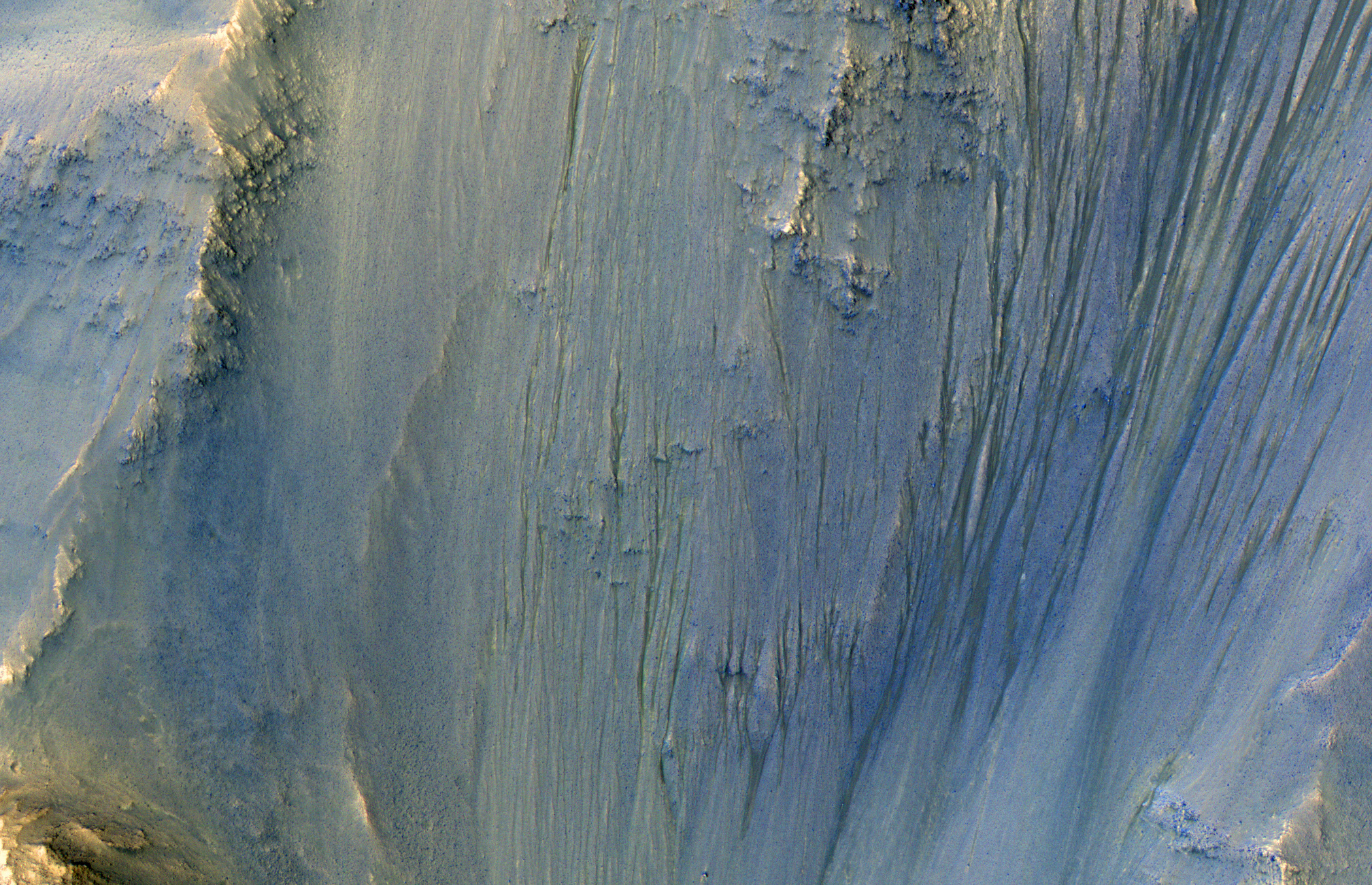
Alfred McEwen wrote:In the Gullies and Bedrock of Ius Chasma (ESP_058580_1720) (HiClip)
This image was acquired in Ius Chasma, a major section of the western portion of the giant Valles Marineris trough.
We see a portion of a steep slope with gullies extending downhill (towards bottom of image). Many of the gully floors are dark, and in some places that dark material extends onto the fan-shaped deposits of the gullies. These dark features are candidates for recurring slope lineae (RSL), which are seasonal features that grow incrementally. The relation between RSL and gullies is not clear: does the RSL activity carve the gullies, or do they simply follow the gully topography created by other processes?
Another closeup from this observation shows part of the floor of Ius Chasma, with layered bedrock draped by dunes.
Credit: NASA/JPL-Caltech/University of Arizona
Know the quiet place within your heart and touch the rainbow of possibility; be
alive to the gentle breeze of communication, and please stop being such a jerk. — Garrison Keillor
-
bystander
- Apathetic Retiree
- Posts: 21577
- Joined: Mon Aug 28, 2006 2:06 pm
- Location: Oklahoma
Post
by bystander » Sun Apr 07, 2019 4:10 pm
Week of 01 April 2019
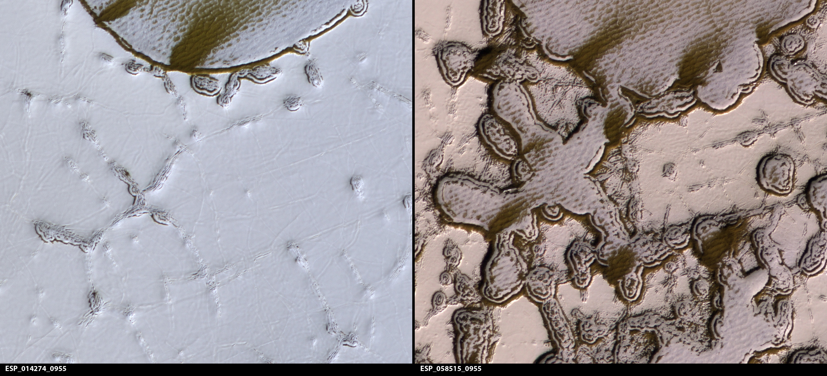
Alfred McEwen wrote:Dramatic Changes over the South Polar Cap (ESP_058515_0955) (HiClip)
The south polar residual cap of carbon dioxide ice rapidly changes. This image was planned as an almost exact match to the illumination and viewing angles of a previous one we took
in August 2009.
The pits have all expanded and merged, and we can just barely see the patterns in the 2009 image compared to this January 2019 picture. The 2009 image is also brighter and bluer, with more seasonal frost and/or less dust over the surface. These images were both taken in late southern summer, but our 2019 picture is slightly later in the Martian season by about two weeks.
This gap allowed for additional loss of frost that might make the surface darker, but there are also year-to-year changes. In particular, there was a near-global dust storm in the summer of 2018 and late southern spring on Mars, and extra deposits of dust would have warmed the surface and promoted even more disappearance of the frost.
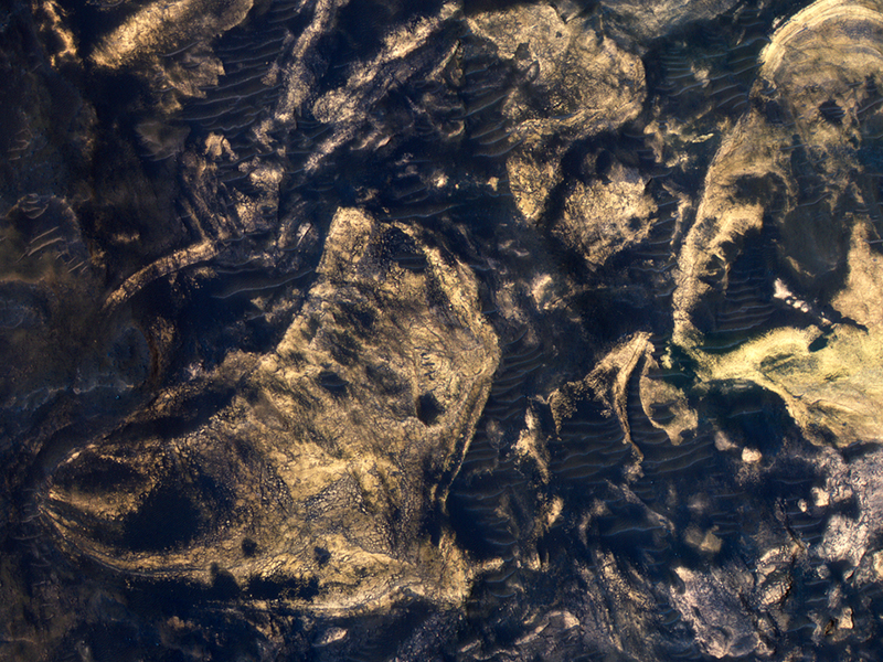
Alfred McEwen wrote:Clay-Rich Terrain in Eridania Basin (ESP_058610_1515) (HiClip)
HiRISE reveals small-scale shapes that often correlate with mineral units and provides information about stratigraphy (i.e., what’s on top and relative ages). This image was acquired for co-analysis with a spectrometer instrument also on our spacecraft called CRISM (Compact Reconnaissance Imaging Spectrometer for Mars). It shows polygonal units that match clay-rich areas. Plus,
this region is colorful!
This location, in Eridania Basin, was the site of an ancient lake, so these clay-rich sediments may have been habitable.
While CRISM cannot acquire new data from their infrared channel due to lack of cooling, they have acquired much previous data that lacks HiRISE coverage.
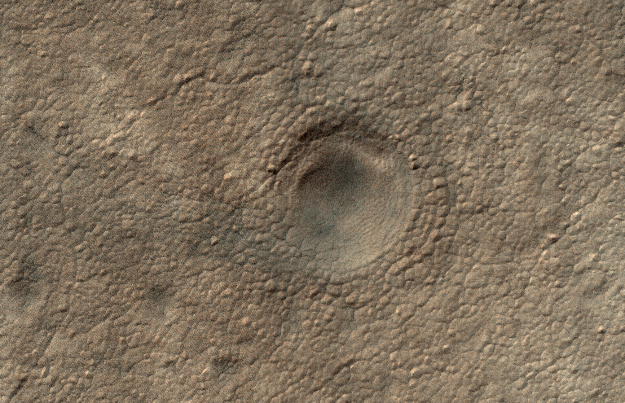
Alfred McEwen wrote:A Crater on the South Polar Layered Deposits (ESP_058600_0990) (HiClip)
This image is part of a campaign to image potential impact craters in the south polar layered deposits (ice cap).
This feature looks like a strong candidate for an impact crater because it is very circular are still has a raised rim.
The sizes and densities of impact craters provide an estimate for the age of the landscape, which in turn provides a minimum age for the icy layers.
Credit: NASA/JPL-Caltech/University of Arizona
Know the quiet place within your heart and touch the rainbow of possibility; be
alive to the gentle breeze of communication, and please stop being such a jerk. — Garrison Keillor
-
bystander
- Apathetic Retiree
- Posts: 21577
- Joined: Mon Aug 28, 2006 2:06 pm
- Location: Oklahoma
Post
by bystander » Tue Apr 16, 2019 9:44 pm
Week of 15 April 2019
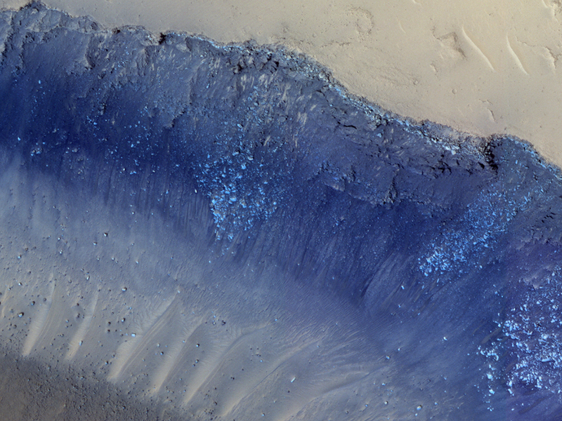
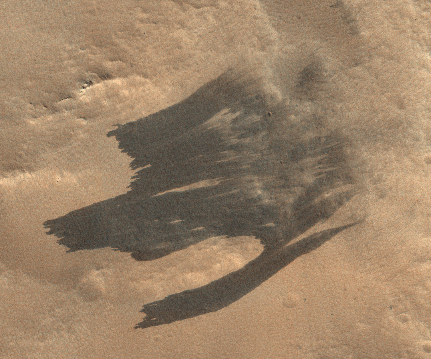
Alfred McEwen wrote:Landslides in Cerberus Fossae (ESP_058571_1965) (HiClip)
Cerberus Fossae is a steep-sided set of troughs cutting volcanic plains to the east of Elysium Mons. Steep slopes on Mars have active landslides (also called “mass wasting”), and here we see evidence for two types of activity.
First,
the light bluish boulders on the slope appear to originate at a layer of bedrock (also light blue) near the top of the section. Second, the dark thin lines are recurring slope lineae, probably also due to mass wasting, but composed of finer-grained materials.
Credit: NASA/JPL-Caltech/University of Arizona
Know the quiet place within your heart and touch the rainbow of possibility; be
alive to the gentle breeze of communication, and please stop being such a jerk. — Garrison Keillor
-
bystander
- Apathetic Retiree
- Posts: 21577
- Joined: Mon Aug 28, 2006 2:06 pm
- Location: Oklahoma
Post
by bystander » Sat May 18, 2019 5:46 pm
Week of 13 May 2019
Colin Dundas wrote:Resistant Lava and Erosion (ESP_058635_1940) (HiClip)
This image demonstrates the curious phenomenon called “topographic inversion.” The southern half of the picture is covered by a well-preserved lava flow. The flow stops just at the brink of descending a steep slope. Lava isn’t afraid of falling, so what happened here?
It is likely that the terrain to the north was once higher, and stopped the lava from flowing any further. Once the lava cooled, it protected the ground beneath it, while the softer rocks to the north continued to erode, “inverting” the topography so that what was once low-lying ground is now the top of a mesa.
Catherine Weitz wrote:A Snow Plow Landslide (ESP_058960_1800) (HiClip)
This image shows a small landslide in Iani Chaos. Landslides are common on Mars where there are steep slopes, including this area where there are numerous mounds and hills.
What is unusual about this landslide is that it carved a path downslope as it moved, similar to a snow plow pushing away snow as it moves forward. This image is part of a stereo pair so that scientists will examine the landslide in 3D to understand its formation mechanism.
This is a stereo pair with
ESP_058894_1800.
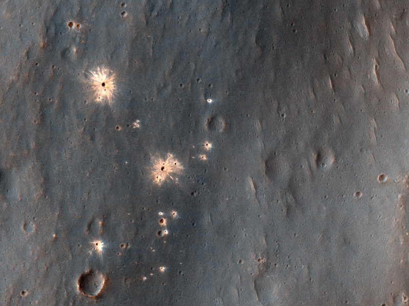
HiRISE Science Team wrote:The Changing Surface of Mars (ESP_059329_2095) (HiClip)
HiRISE commonly takes images of recent craters on Mars, which are usually found by the MRO Context Camera where they disturb surface dust. An impact site in this area was
first imaged in December 2017.
A year and a half later, the scene looks totally different! Dust has eroded from the surface, probably due to the planet-encircling dust storm from 2018. The dark spots around the fresh craters have vanished because they only affected the dust that has since disappeared. See if you can find the craters in the new image
by comparing with the old one.
Credit: NASA/JPL-Caltech/University of Arizona
Know the quiet place within your heart and touch the rainbow of possibility; be
alive to the gentle breeze of communication, and please stop being such a jerk. — Garrison Keillor
-
bystander
- Apathetic Retiree
- Posts: 21577
- Joined: Mon Aug 28, 2006 2:06 pm
- Location: Oklahoma
Post
by bystander » Tue Jun 11, 2019 8:58 pm
Week of 10 June 2019
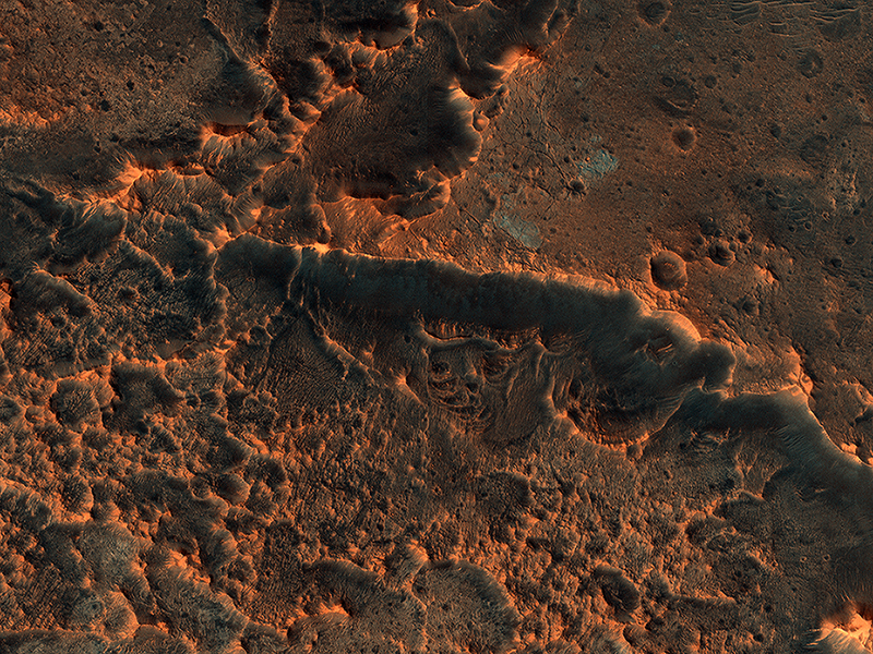
Susan Conway wrote:Tooting Crater Ejecta (ESP_057013_2045) (HiClip)
In this picture
we can see a huge tongue-like form, which looks a like a mudflow with boulders on its surface. This “tongue” is only a small part of a larger deposit that completely surrounds Tooting Crater (not visible in this image). This is part of what is called an “ejecta blanket.”
The shape and form of the deposits in the ejecta blanket can tell us about the condition of the ground when the impact crater was formed. The presence of this tongue of ejecta is interpreted as a sign that the ground was frozen before impact. The force of the impact melted ice and mixed it with rock and dust as it was thrown away from the crater. It then settled to form these tongue-like lobes all around the crater.
Susan Conway wrote:Rhythmic Layers East of Medusae Fossae (ESP_057092_1770) (HiClip)
The surface of this image looks wavy, like that of the sea. These wave shapes are the result of erosion: the removal of material, which has been ongoing for millions, if not billions, of years. This erosion is likely performed by the action of wind and has revealed layered rock that was deposited in this area in the ancient past.
The layers were deposited very regularly one on top of another and the erosion has cut across them—sometimes shallowly, sometimes more deeply—to create these giant undulations. More resistant layers protrude further, making them the visible crests of the waves.
This is a stereo pair with
ESP_057303_1770.
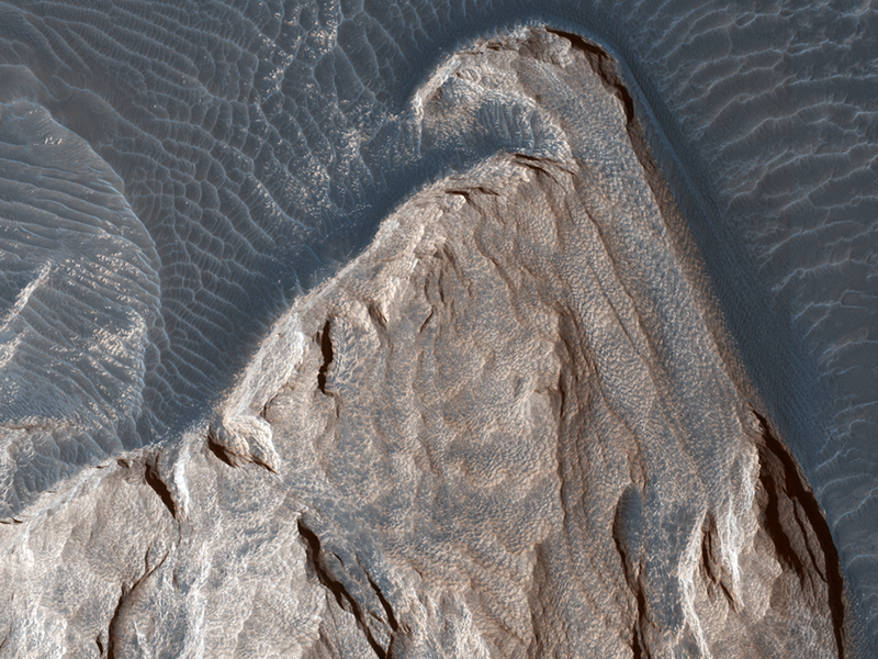
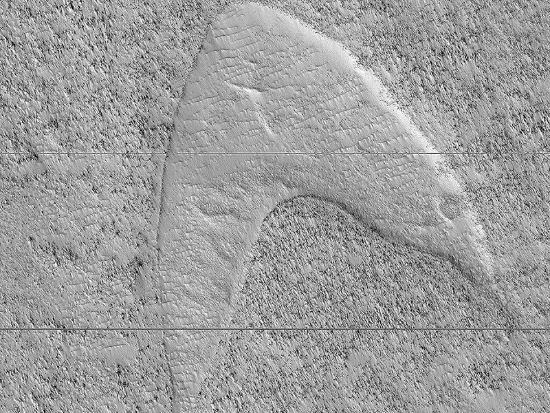
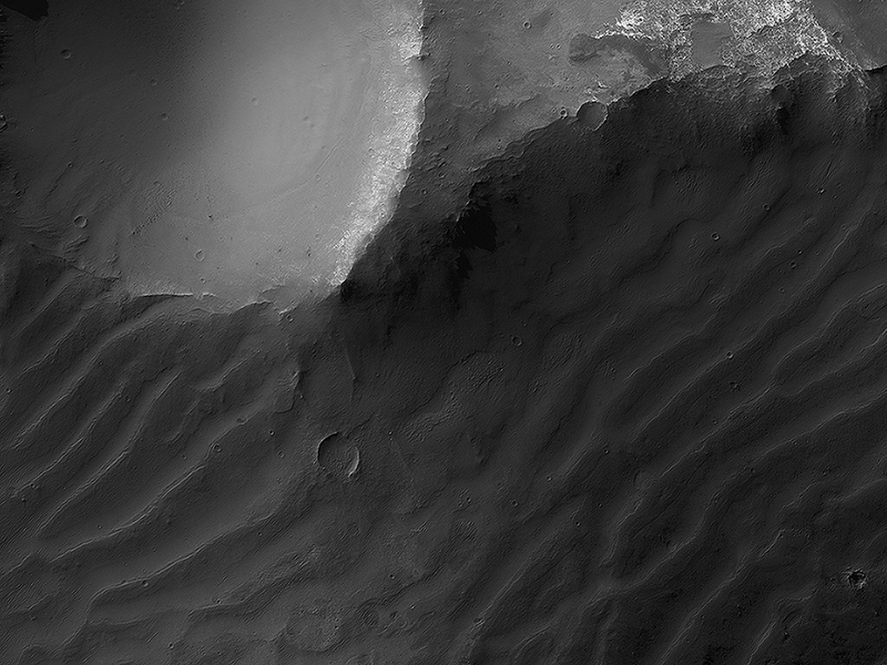
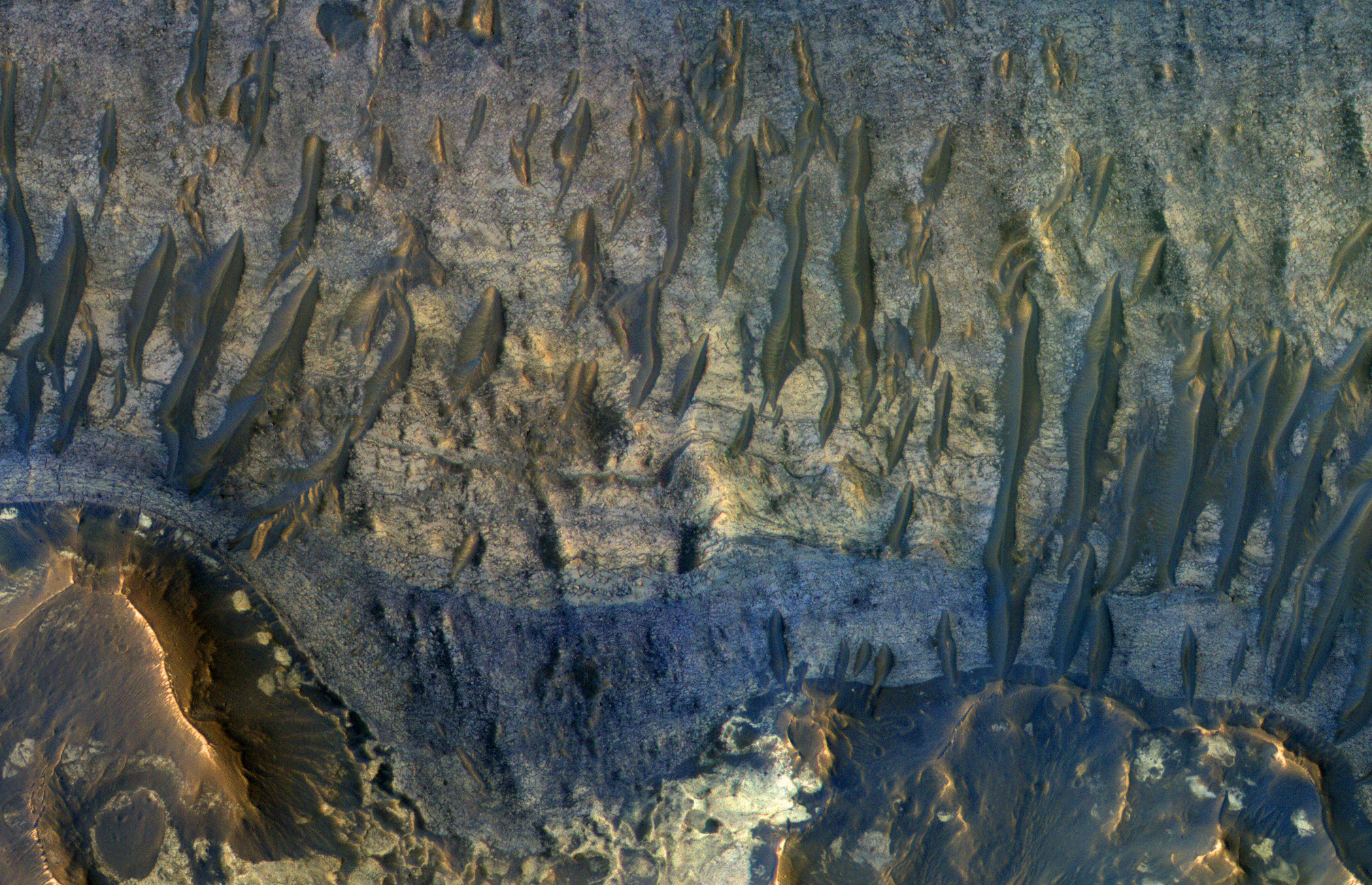
Ross Beyer wrote:Dune Footprints in Hellas (ESP_059708_1305) (HiClip)
These curious chevron shapes in southeast Hellas Planitia are the result of a complex story of dunes, lava, and wind.
Long ago, there were large crescent-shaped (barchan) dunes that moved across this area, and at some point, there was an eruption. The lava flowed out over the plain and around the dunes, but not over them. The lava solidified, but these dunes still stuck up like islands. However, they were still just dunes, and the wind continued to blow. Eventually, the sand piles that were the dunes migrated away, leaving these “footprints” in the lava plain. These are also called “dune casts” and record the presence of dunes that were surrounded by lava.
Enterprising viewers will make the discovery that these features look conspicuously like a famous logo: and you’d be right, but it’s only a coincidence.
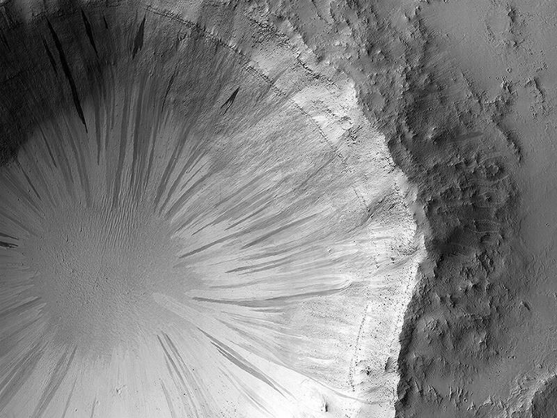
John Bridges wrote:Landing in Oxia Palus (ESP_060015_1980) (HiClip)
This image shows a cratered area to the southeast of the ExoMars 2020 Rosalind Franklin rover landing site at Oxia Palus.
Selecting and characterizing landing sites is a balance between having science targets and avoiding potential obstacles, and HiRISE is used for both purposes.
Craters like this one excavate material from within the crust, including both sedimentary and igneous rocks, and scatter this material far from the crater itself. This is one of the ways that so-called “float rocks” (rocks that are not connected to their original outcrop) can occur across a landing site: they are often ejecta from distant impacts.
Here, an ejecta blanket is visible in the rays of material surrounding this 2-kilometer diameter crater. The ExoMars rover has a suite of cameras and a close-up imager (called CLUPI) that will be used to study these float rocks. Studying such samples has been an important way of learning about the deep crust of Mars on previous missions, notably the Spirit and Opportunity rovers and now, Curiosity.
Credit: NASA/JPL-Caltech/University of Arizona
Know the quiet place within your heart and touch the rainbow of possibility; be
alive to the gentle breeze of communication, and please stop being such a jerk. — Garrison Keillor
-
bystander
- Apathetic Retiree
- Posts: 21577
- Joined: Mon Aug 28, 2006 2:06 pm
- Location: Oklahoma
Post
by bystander » Mon Sep 30, 2019 7:29 pm
Week of 03 Sep 2019
Ross Beyer wrote:Frost Highlights in the Springtime (ESP_059681_2410) (HiClip)
This image of a crater rim strikingly shows what appear to be bright white flows coming from gullies in the crater wall. However, HiRISE has been watching these gullies for some time (going all the way back to our
first observation in 2012) and the flow features have been there for years. The new aspect is the bright white coloration, which is frost.
This is the earliest in the springtime that this area has been observed, and just like some winter mornings here on Earth, the conditions on Mars can be just right for frost to form. The interesting thing is that the frost appears on the gully deposits and not as much on the surrounding rock, indicating the physical properties of the gully deposits are different.
John Bridges wrote:The Bedrock Riddles of Nili Fossae (ESP_060064_2005) (HiClip)
This image of the Nili Fossae region, to the west of the great Isidis basin, shows layered bedrock with many impact craters.
Nili Fossae is one of the most
mineralogically important sites on Mars. Remote observations by the infrared spectrometer onboard MRO (called CRISM) suggest the layers in the ancient craters contain clays, carbonates, and iron oxides, perhaps due to hydrothermal alteration of the crust. However, the impact craters have been degraded by many millions of years of erosion so the original sedimentary, impact ejecta, or lava flows are hard to distinguish.
The bright linear features are sand dunes, also known as “transverse aeolian dunes,” because the wind direction is at ninety degrees to their elongated orientation. This shows that the erosion of Nili Fossae continues to the present day with sand-sized particles broken off from the local rocks mobilized within the dunes.
This is a stereo pair with
ESP_052389_2005.
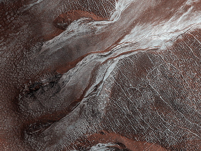
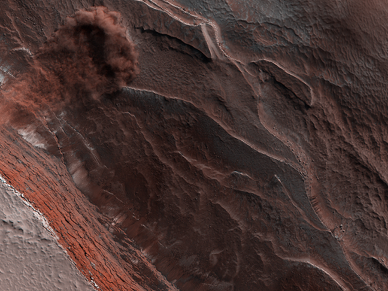
Candy Hansen wrote:Avalanche Season (ESP_060176_2640) (HiClip)
Every spring the sun shines on the side of the stack of layers at the North Pole of Mars known as the north polar layered deposits. The warmth destabilizes the ice and blocks break loose.
When they reach the bottom of the more than 500 meter tall cliff face,
the blocks kick up a cloud of dust. (In the cutout, the top layer of the north polar cap is to the lower left.) The layers beneath are different colors and textures depending on the amount of dust mixed with ice.
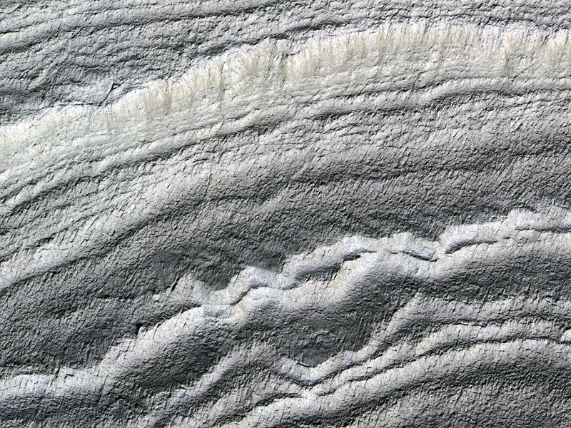
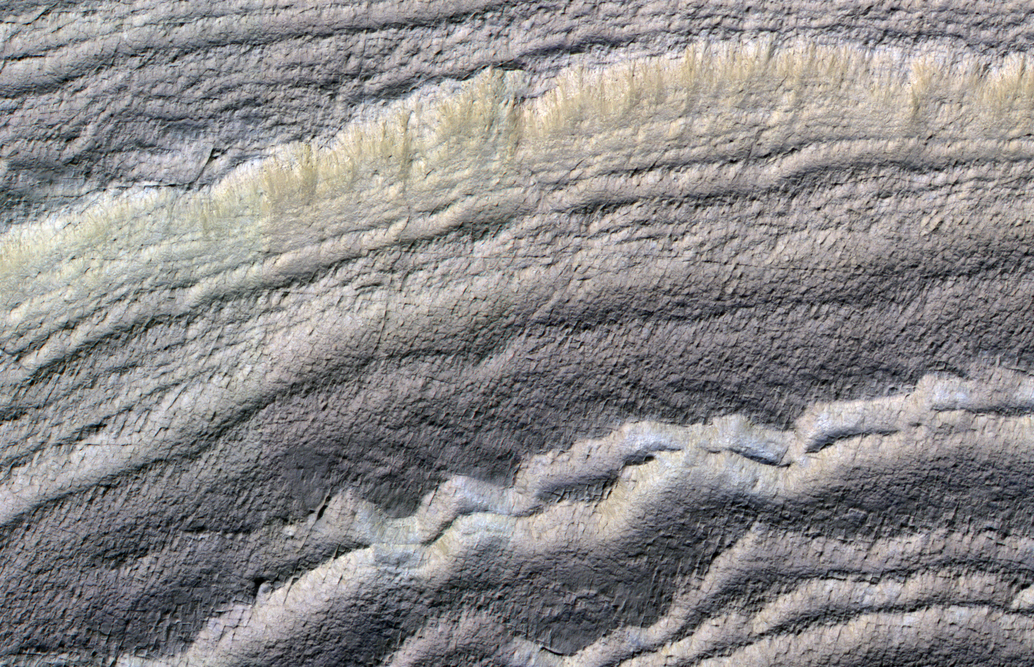
James Wray wrote:Layers in Danielson Crater (ESP_060331_1880) (HiClip)
This image shows sedimentary rock and sand within Danielson Crater, an impact crater 67 kilometers in diameter, located in the southwest Arabia Terra region of Mars.
The rock was formed millions or billions of years ago when loose sediments settled into the crater, one layer at a time, and were later cemented in place. Cyclical variations in the sediment properties made some layers more resistant to erosion than others. After eons, these tougher layers protrude outward like stair steps. Across these steps, the winds have scattered sand (typically appearing darker and less red, i.e. “bluer” in contrast-enhanced color), giving rise to the zebra stripe-like patterns
visible here.
This image completes a stereo pair over this location, which will allow measurement of the thicknesses of these sedimentary layers. The layer thicknesses and how they vary through time can provide some insight into the processes, possibly linked to ancient climate, that deposited the layers so long ago.
This is a stereo pair with
ESP_027615_1880.
Credit: NASA/JPL-Caltech/University of Arizona
Know the quiet place within your heart and touch the rainbow of possibility; be
alive to the gentle breeze of communication, and please stop being such a jerk. — Garrison Keillor
-
bystander
- Apathetic Retiree
- Posts: 21577
- Joined: Mon Aug 28, 2006 2:06 pm
- Location: Oklahoma
Post
by bystander » Mon Sep 30, 2019 7:48 pm
Week of 16 Sep 2019
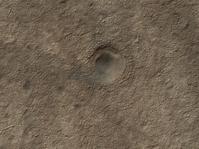
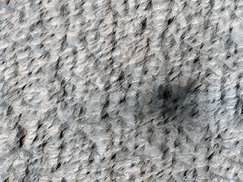
Ken Herkenhoff wrote:Subliming Ice (ESP_060698_2220) (HiClip)
This enhanced-color image shows a 45-meter-diameter crater that formed sometime between October 2010 and May 2012 in so-called “brain” terrain on Mars. HiRISE has been monitoring this crater to look for changes in the bright icy material exposed in the crater wall and some of the ejecta blocks.
This material is interpreted as water ice because its extent changes with time, consistent with slow sublimation caused by solar heating. (Sublimation is the process when a solid converts directly into a gaseous state.) By comparing this image with another one (
ESP_046707_2220) taken in July 2016, we see that some of the ejecta blocks have vanished since then. It appears that fresh ice has been exposed on the east wall of the crater since 2016, perhaps due to slumping of dirty material. When we apply different color enhancements to these two images, we see that the color of the scene did not actually change much.
Veronica J. Bray wrote:Bonus Beauty (ESP_060857_1930) (HiClip)
This observation was originally intended to image the “contact” between two terrain types: a rocky ridge separates the rugged left from the smoother right side. But during planning, a targeting specialist chose to extend the image further north (to the top), to capture a nearby crater. (Extending images for some extra coverage is common practice when data volume allows.)
That extension has given us a bonus beauty!
The steep walls of the crater are
covered with slope streaks formed by material falling down towards the crater’s center. There are so many in this case that the crater is reminiscent of a delicate “dandelion clock.” Looking closer, we can also see that the exposed layering gives us more information about the subsurface of Mars.
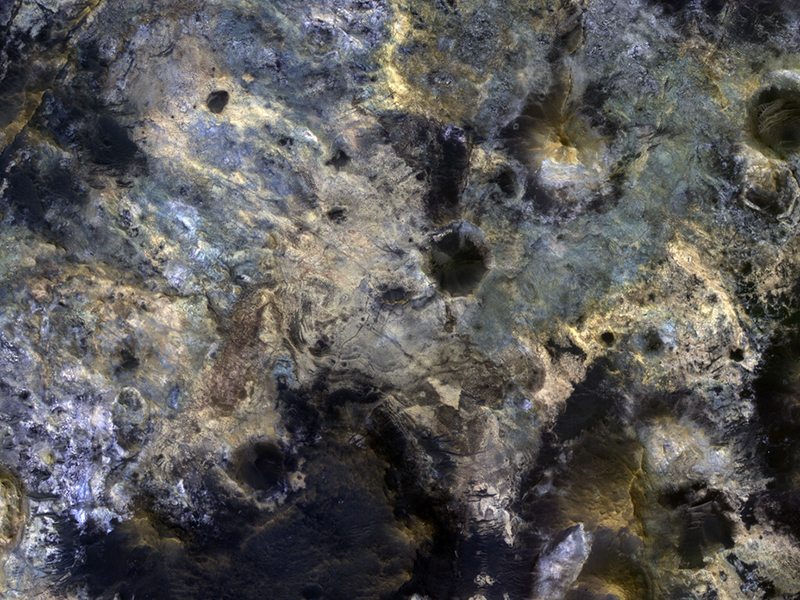
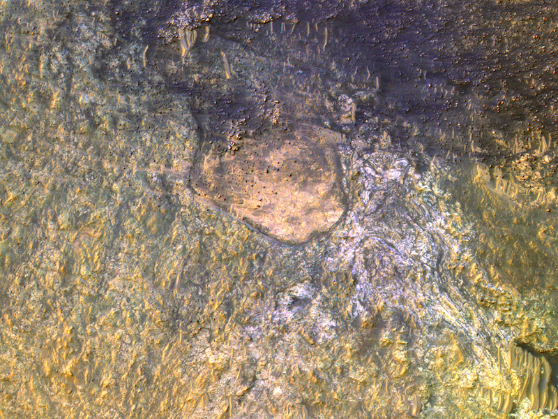
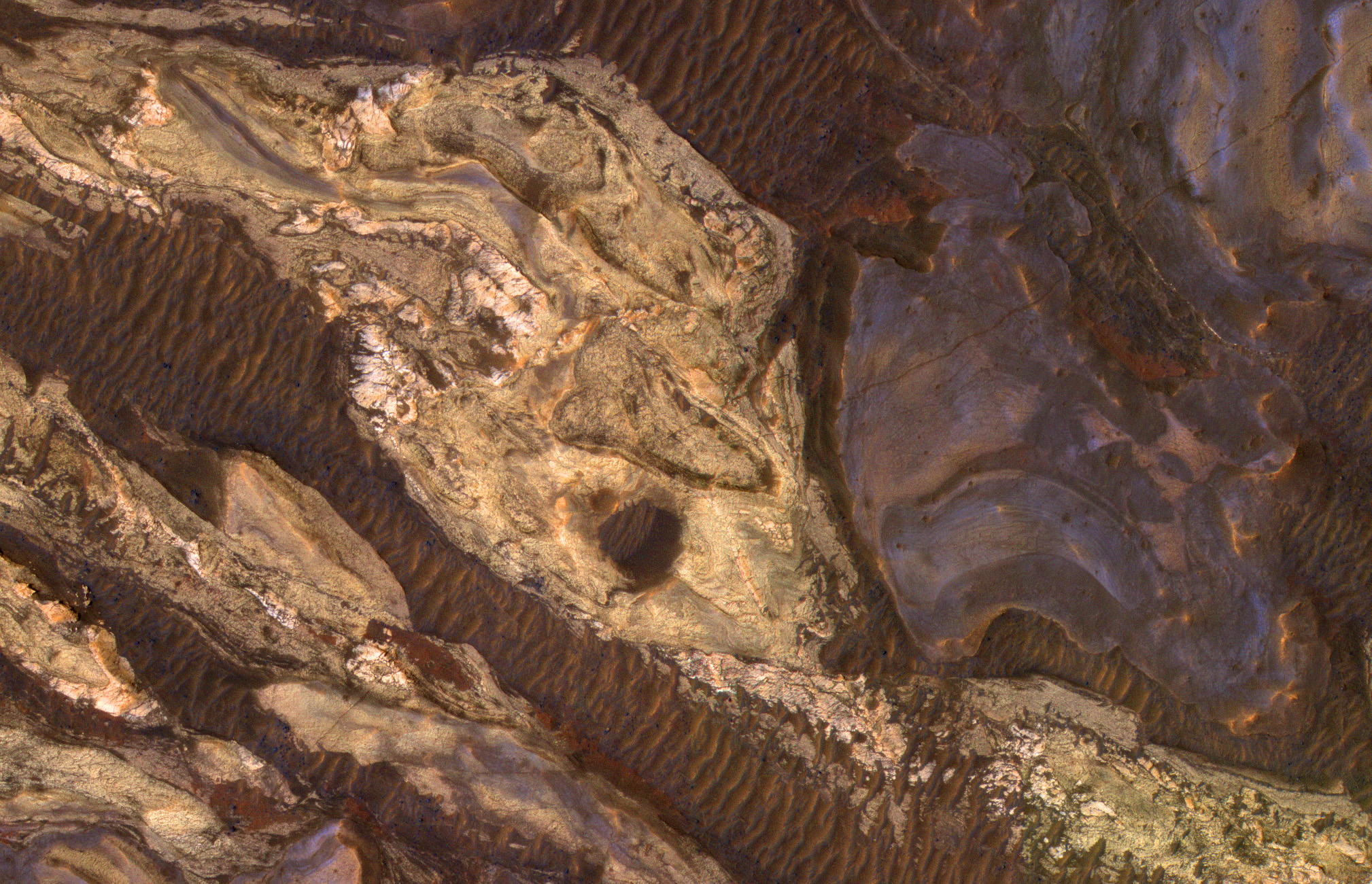
Alfred McEwen wrote:Mars Underground Exposed: The Central Peak of Alga Crater (ESP_060978_1555) (HiClip)
The most habitable places on Mars now and in the past are underground, where water is or was much more stable than at the surface and protected from energetic particle radiation.
Large impact craters have central rebounds that uplift buried strata from miles below the surface. Often these central uplifts reveal colorful rocks with diverse minerals, including ones altered by prolonged contact with water.
Alga Crater is located in the southern highlands near a large flood-channel called Ladon Valles. The
image cutout shows enhanced (infrared-shifted) color.
Credit: NASA/JPL-Caltech/University of Arizona
Know the quiet place within your heart and touch the rainbow of possibility; be
alive to the gentle breeze of communication, and please stop being such a jerk. — Garrison Keillor
-
bystander
- Apathetic Retiree
- Posts: 21577
- Joined: Mon Aug 28, 2006 2:06 pm
- Location: Oklahoma
Post
by bystander » Thu Oct 17, 2019 3:04 pm
Week of 14 Oct 2019
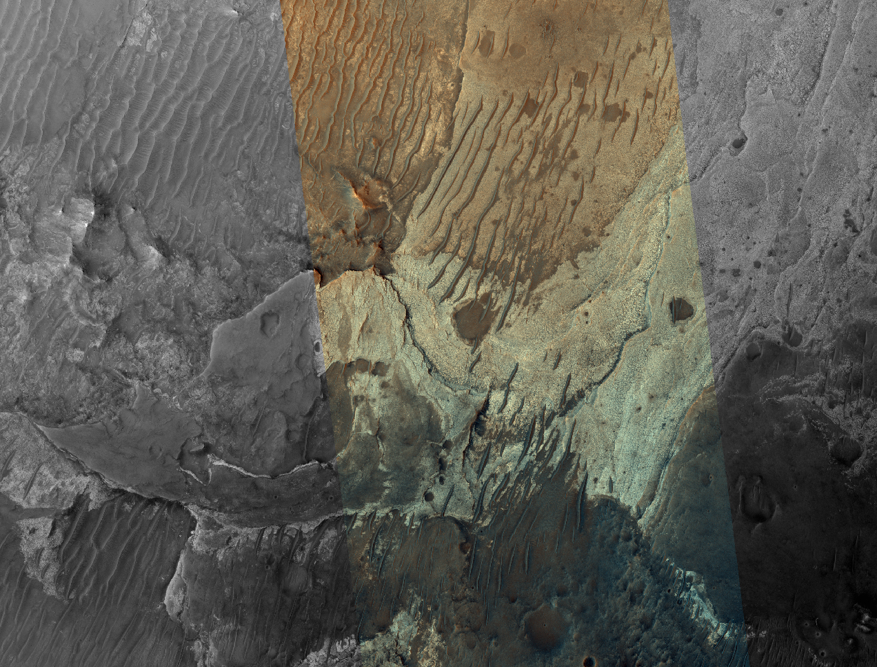
Matthew Chojnacki wrote:Enigmatic Canyon Dunes (ESP_052737_1645) (HiClip)
This image shows a cross-section of ancient canyon systems in east Coprates Chasma, and displays several orders and generations of wind-driven dunes and ripples, also called bedforms.
Some areas display more modern bedforms, often termed mega-ripples, which have likely been active over long timescales and have migrated in the recent past.
Other areas along the canyon wall have larger bedforms that show a very different appearance. Although they have a spacing that would make them similar to typical Martian sand dunes, many display superposed craters, indicating they have not migrated for a very long time, possibly hundreds of thousands of years.
This is a stereo pair with
PSP_009143_1645.
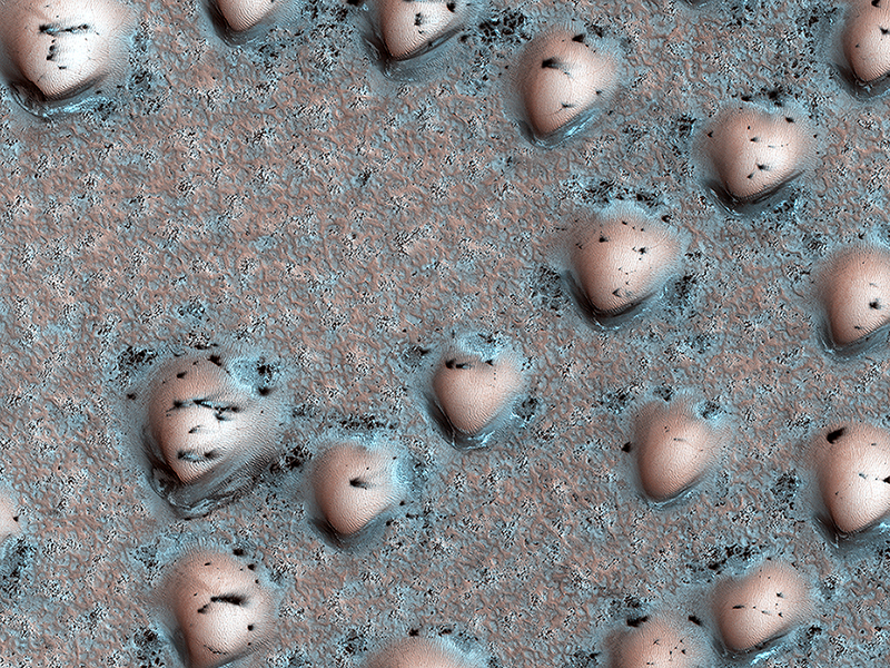
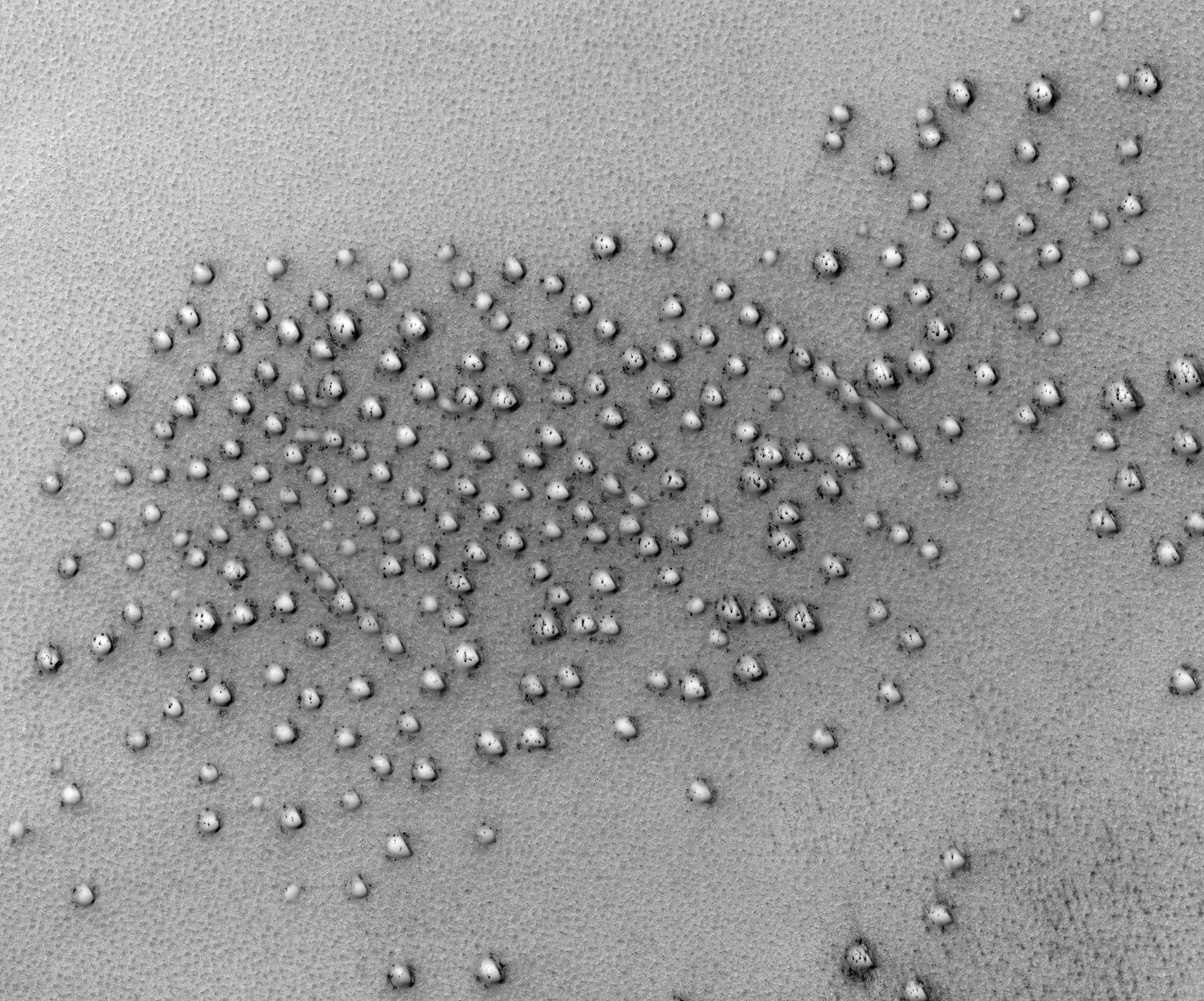
Ken Herkenhoff wrote:A Martian Game Board (ESP_060791_2550) (HiClip)
It’s spring in the Northern Hemisphere of Mars, and the polar region is still blanketed by seasonal carbon dioxide frost (dry ice). This image shows an area near the sand sea (called an “erg”) that is surrounding the water ice-rich layered deposits.
The many bumps are sand dunes less than 100 meters across that are mostly covered by seasonal frost, appearing in a manner that looks artificial but is a natural consequence of the wind patterns in this region. The smaller, darker spots are places where the seasonal frost has sublimed away, exposing the dark surface below. The combination of these features makes for an unearthly scene!
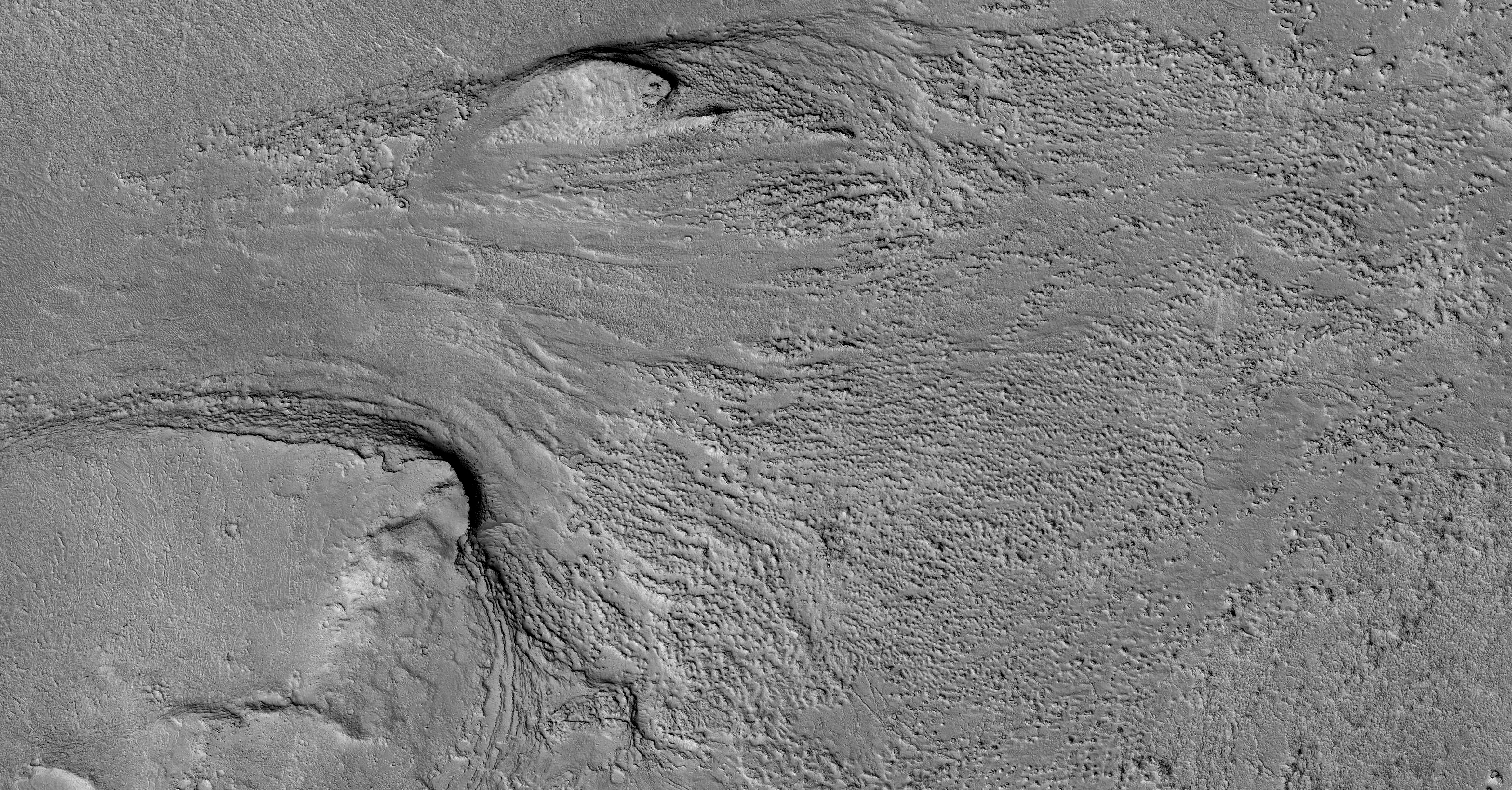
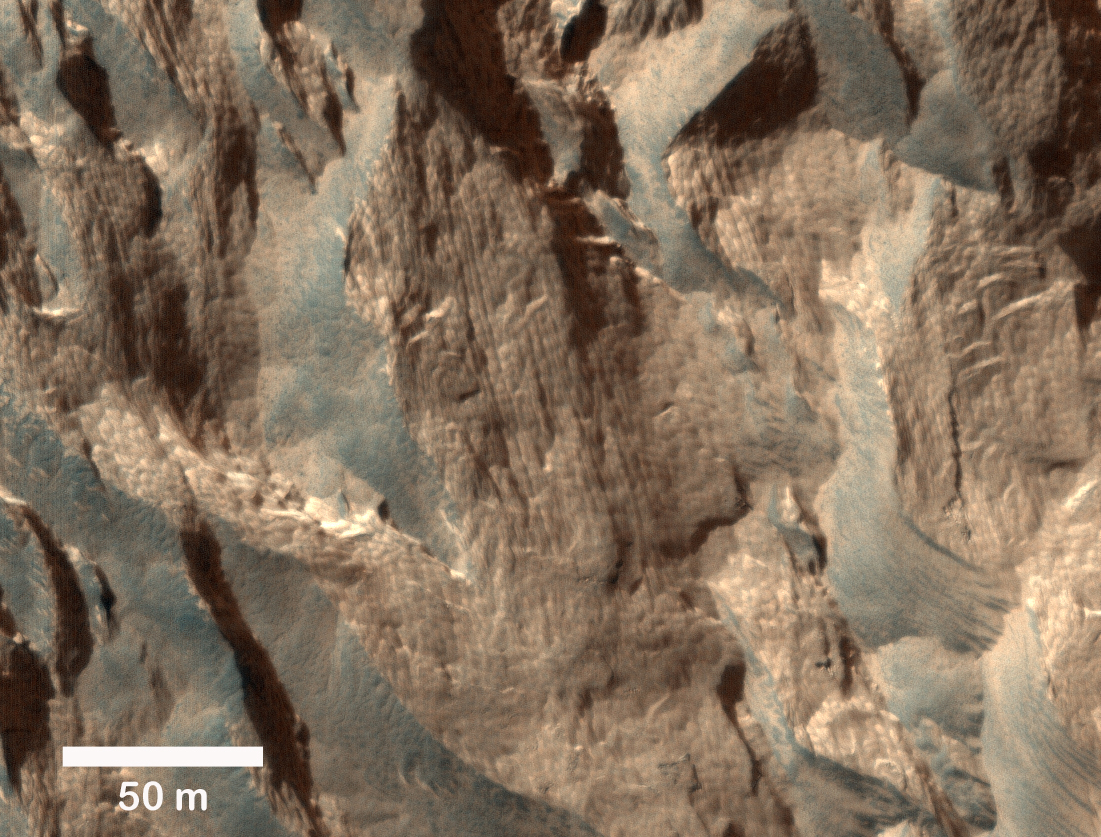
Dan Berman wrote:Down in Chukhung Crater (ESP_060953_2185) (HiClip)
Chukhung is a 45 kilometer-diameter, central pit crater in Tempe Terra, having likely formed 3 billion years ago. The southern portion of the crater floor hosts a large viscous flow feature that is hypothesized to be a glacier.
There are sinuous ridges that emanate from the margin of the flow feature toward the center of the crater. These ridges could be evidence of glacial meltwater preserved in the form of eskers, inverted channels formed when the softer sediments surrounding the channel deposits are eroded away. It is unclear whether the conditions for wet-based glaciation ever existed on Mars, but these ridges could be evidence that it once did.
This is a stereo pair with
ESP_060676_2185.
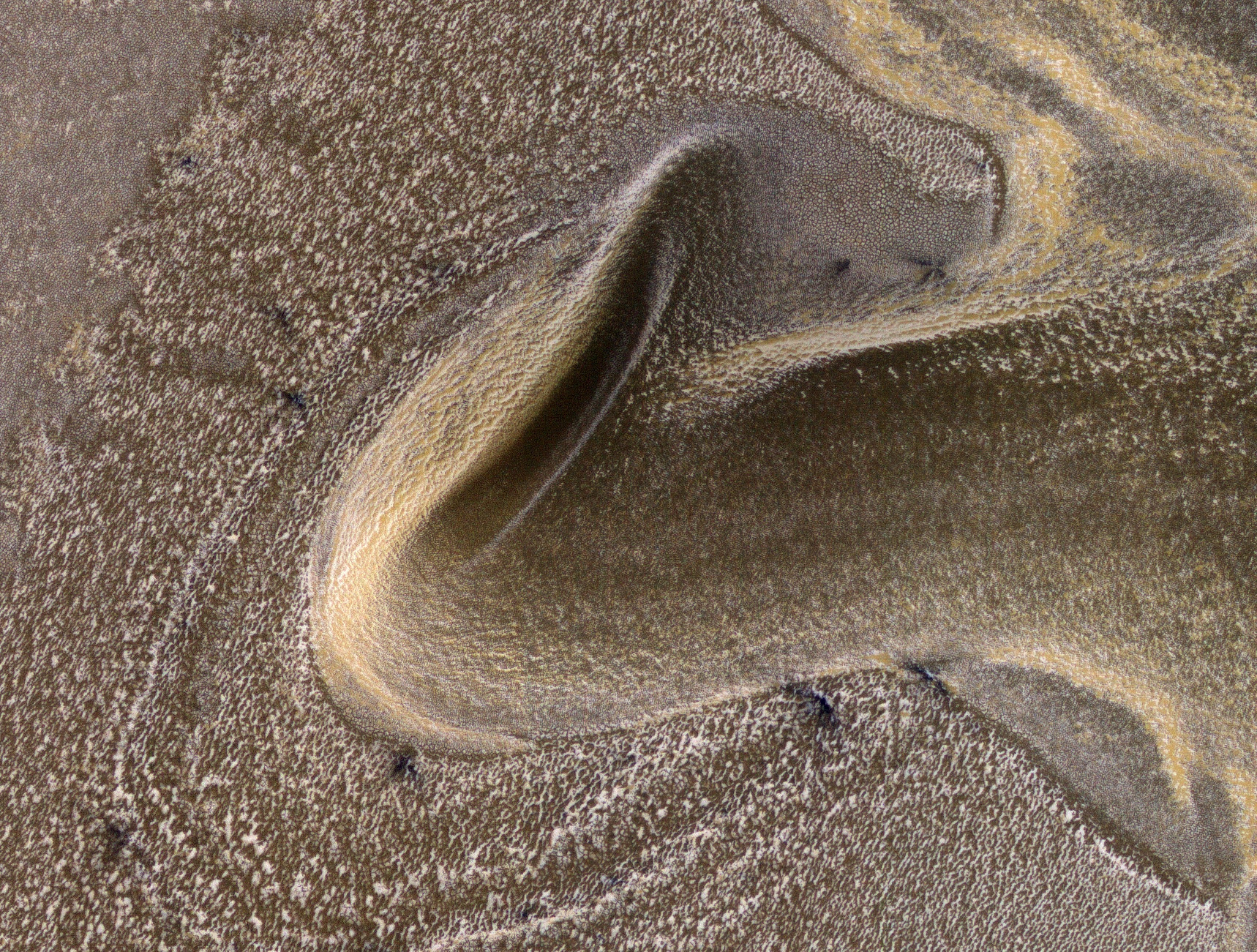
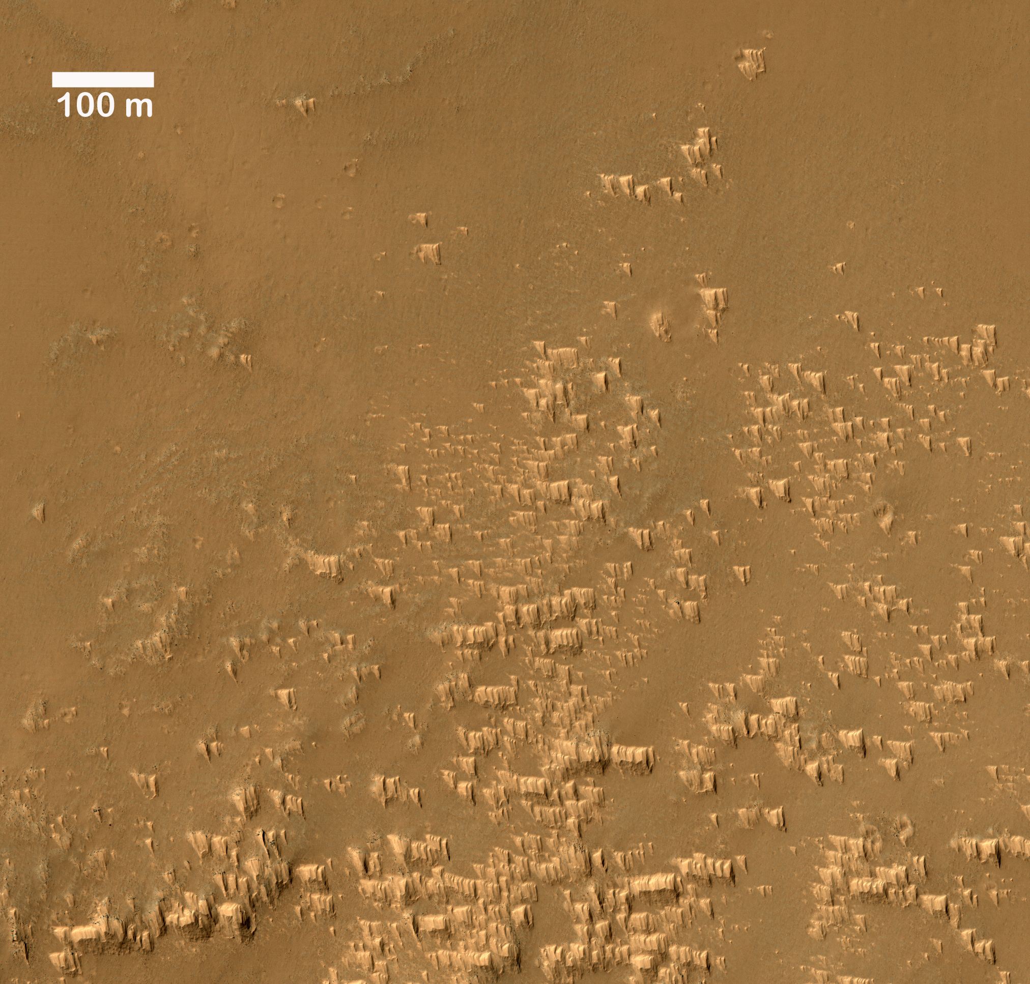
Paul Geissler wrote:Pristine Dust Deposits in Syria Planum (ESP_061126_1680) (HiClip)
Wind-blown deposits known as transverse aeolian ridges (TARs) are frequently visible in images of the Martian tropics. They are bright ripples with heights of 2.6 meters and spacing that averages 47 meters. The TARs generally appear inactive and eroded, sometimes cratered or littered with boulders from nearby impacts and avalanches.
In Syria Planum, unusual bright deposits might be accumulations of dust blown from higher to lower elevations by nighttime slope winds, reaching speeds of up to 50 meters per second. These dust deposits resemble TARs in height and spacing but with a distinct shape from other TARs. A
close up view shows that the deposits form pyramidal features with steep faces on the upwind sides (wind is blowing from the top of the picture) and tapered slopes in the downwind direction. Ridges form where the “pyramids” line up together, and the spacing of the ridges appears to be controlled by the length of the “pyramids.”
These observations suggest that TARs elsewhere on Mars may have formed in a similar fashion, perhaps millions of years ago when the atmosphere was more active. They also may be forming in Syria Planum today.
Credit: NASA/JPL-Caltech/University of Arizona
Know the quiet place within your heart and touch the rainbow of possibility; be
alive to the gentle breeze of communication, and please stop being such a jerk. — Garrison Keillor
-
bystander
- Apathetic Retiree
- Posts: 21577
- Joined: Mon Aug 28, 2006 2:06 pm
- Location: Oklahoma
Post
by bystander » Thu Oct 17, 2019 3:26 pm
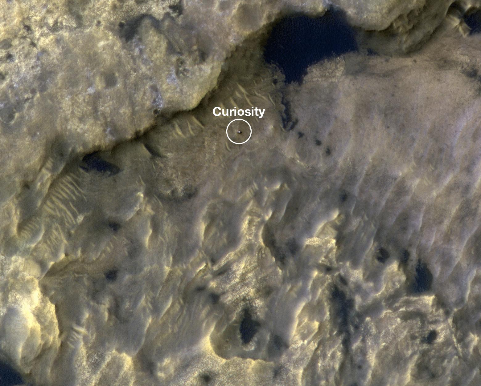
HiRISE Views InSight and Curiosity on Mars
NASA | JPL-Caltech | University of Arizona | LPL | 2019 Oct 16
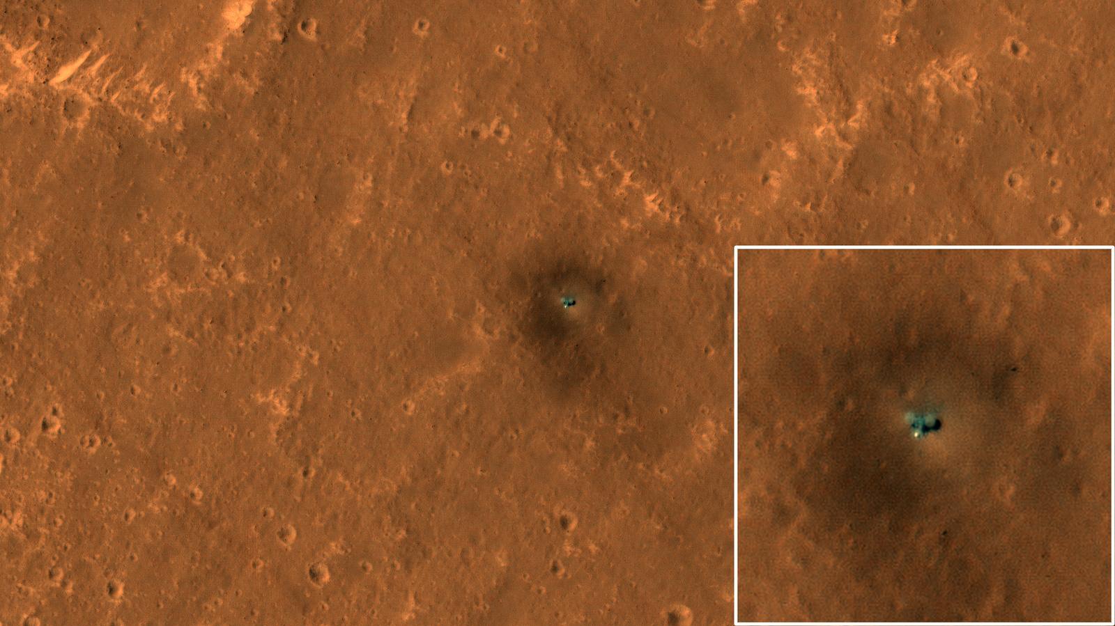
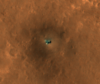
Alfred McEwen wrote:The Best HiRISE Image of the InSight Lander (ESP_061684_1845)
HiRISE has been monitoring the InSight landing site for changes such as new dust-devil tracks, but the lander itself may appear different in each image.
This new image is our
best view yet of the lander, clearly showing the two circular solar panels on either side of the lander body, and the bright spot which is the cover over the seismometer. Why is this lander image clearer than past images?
There are multiple contributors that improve the contrast. First, the air is clearer of dust this time of year. Second, this is an oblique view looking west, so the shadows are offset from the lander. Third, the illumination and viewing directions do not lead to any bright mirror-like reflections from the lander or solar panels, which can obscure surrounding pixels.
The seismometer cover to the south of the lander is still bright because its hemispherical shape always produces a mirror-like reflection over some small area.
Credit: NASA/JPL-Caltech/University of Arizona
Know the quiet place within your heart and touch the rainbow of possibility; be
alive to the gentle breeze of communication, and please stop being such a jerk. — Garrison Keillor
-
bystander
- Apathetic Retiree
- Posts: 21577
- Joined: Mon Aug 28, 2006 2:06 pm
- Location: Oklahoma
Post
by bystander » Thu Nov 28, 2019 6:38 pm
Week of 18 Nov 2019
Ken Herkenhoff and Mike Mellon wrote:Polygonal Patterns Highlighted by Frost (ESP_060685_2480) (HiClip)
It’s spring in the Northern Hemisphere of Mars (when this image was taken), and this area was recently completely covered by the seasonal frost cap. Here, we see
polygonal patterns that are highlighted by carbon dioxide frost that has not entirely sublimed away.
These organized patterns are likely caused by differences in the soil (regolith) characteristics such as grain size, density, even grain-shape and orientation in the underlying landforms and geologic materials. Variations in these characteristics strongly influence the strength of the ice-rich permafrost. This gives a preferred orientation to the stress field that produces the polygonal patterns.
In this case, there appears to have been a meander in a fluvial channel in which sediments that differ from the native soil were deposited. The physical properties of these sediments probably change near the channel banks where flow rate drops off. Additionally, a high ice content might have resulted from a sediment-rich slurry flow that froze in place. Higher ice content will produce a weaker stress field and larger polygons, more so than just changes in grain size or orientation.
Dan Berman wrote:Pits, Hollows and Viscous Flow (ESP_060858_2160) (HiClip)
The mid-latitudes of Mars are draped with deposits of water ice and dust on the order of tens of meters thick. The deposits are preserved to varying degrees, depending on latitude and the degree of dust cover that insulates and protects the ice from subliming away.
These mantling deposits are thought to have been mobilized from the polar caps and redeposited from the atmosphere millions of years ago during periods when Mars’ axial tilt was higher than it is today.
The floor of this crater appears filled with such deposits, as evidenced by surface textures such as pits, hollows, grooves, and other small filled craters. The material has undergone viscous flow, resulting in many curved ridges. Much of the original ice may have been lost to sublimation, but it is likely that a significant amount of ice remains.
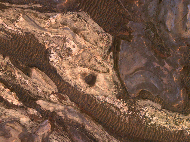
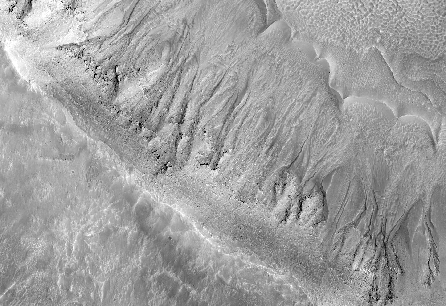
Paul Geissler wrote:Layered Sediments in Valles Marineris (ESP_061085_1740) (HiClip)
Layered sedimentary rocks are key to understanding the geologic history of a planet, recording the sequence of deposition and the changes over time in the materials that were deposited.
These layered sediments are on the floor of eastern Coprates Chasma in Valles Marineris, the grandest canyon on Mars. They are erosional remnants of a formerly much more extensive sedimentary deposit that once filled the floor of the canyon but is nowadays reduced to isolated mesas.
The origin of the deposits is not yet known. Various theories attribute the sediments to wind blown dust and sand, or to volcanic materials, or accumulations of debris from avalanches originating from the canyon walls, or even to lakebed sediments laid down when the canyons were filled with liquid water. Some sediments are devoid of boulders or blocks larger than the limit of resolution (about 0.5 meters), so avalanche debris is unlikely. We see fine laminations with a horizontal spacing of about 2 meters and a vertical separation less than 2 meters. No previous orbital observations were capable of resolving such fine scale layering.
Paul Geissler wrote:Both Ancient and Modern (ESP_061582_2010) (HiClip)
This image of the floor of an old impact crater in Arabia Terra shows evidence of multiple different geological processes, both ancient and modern.
The linear ridges and scarps formed eons ago, perhaps as fractures filled with lava or some other dark material that is more resistant to erosion than the surrounding materials in the crater floor. Boulders up to 3 meters in diameter are strewn downslope on both sides of the
dark ridge near the center of the picture.
The nearby knob is the source of several long dark slope streaks. These dark streaks are probably caused by dust avalanches that remove bright dust and reveal the darker subsurface below. These streaks likely formed within the last few years, based on HiRISE observations of slope streaks elsewhere on Mars.
Credit: NASA/JPL-Caltech/University of Arizona
Know the quiet place within your heart and touch the rainbow of possibility; be
alive to the gentle breeze of communication, and please stop being such a jerk. — Garrison Keillor


