
NASA JPL | 2010-359 | 29 Oct 2010
University of Arizona | 29 Oct 2010
A growing bounty of images from NASA's Mars Reconnaissance Orbiter reveals that the timing of new activity in one type of the enigmatic gullies on Mars implicates carbon-dioxide frost, rather than water, as the agent causing fresh flows of sand.
Researchers have tracked changes in gullies on faces of sand dunes in seven locations on southern Mars. The periods when changes occurred, as determined by comparisons of before-and-after images, overlapped in all cases with the known winter build-up of carbon-dioxide frost on the dunes. Before-and-after pairs that covered periods only in spring, summer and autumn showed no new activity in those seasons.
...
Scientists have suggested various explanations for modern gullies on Mars since fresh-looking gullies were discovered in images from NASA's Mars Global Surveyor in 2000. Some of the proposed mechanisms involve water, some carbon dioxide, and some neither.
Some fresh gullies are on sand dunes, commonly starting at a crest. Others are on rockier slopes, such as the inner walls of craters, sometimes starting partway down the slope.
Diniega and co-authors at the University of Arizona and Johns Hopkins University Applied Physics Laboratory, Laurel, Md., focused their study on dune gullies that are shaped like rockier slope gullies, with an alcove at the top, a channel or multiple channels in the middle, and an apron at the bottom. The 18 dune gullies in which the researchers observed new activity range in size from about 50 meters or yards long to more than 3 kilometers (2 miles) long.
...
Because new flows in these gullies apparently occur in winter, rather than at a time when any frozen water might be most likely to melt, the new report calls for studies of how carbon dioxide, rather than water, could be involved in the flows. Some carbon dioxide from the Martian atmosphere freezes on the ground during winter and sublimates back to gaseous form as spring approaches. The dunes studied are poleward of 40 degrees south latitude.
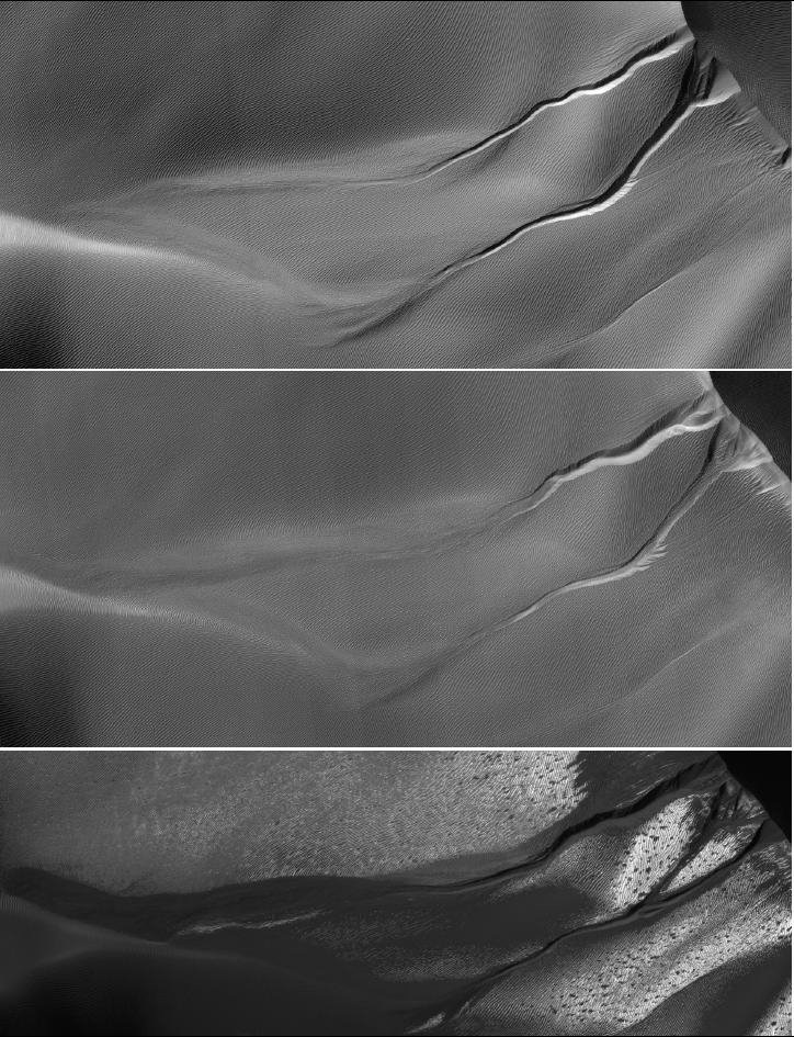
PIA13544: Gully Changes on Martian Sand DuneThe gullies on a Martian sand dune in this trio of images from NASA's Mars Reconnaissance Orbiter deceptively resemble features on Earth that are carved by streams of water. However, these gullies likely owe their existence to entirely different geological processes apparently related to the winter buildup of carbon-dioxide frost.
Credit: NASA/JPL-Caltech/University of Arizona
Scientists at the University of Arizona, Tucson, and at Johns Hopkins University Applied Physics Laboratory, Laurel, Md., compared pairs of images from before and after changes in such dune gullies. They determined that the changes occur in Martian winter, during periods of carbon-dioxide frost, rather than during warmer seasons when frozen water, if present, might somehow melt and flow.
Each of the three images here shows an area about 1.2 kilometers (three-fourths of a mile) across. The dunes lie inside Matara Crater, at 49.4 degrees south latitude, 34.7 degrees east longitude. The images are portions of observations by the High Resolution Imaging Science Experiment (HiRISE) camera on the Mars Reconnaissance Orbiter. HiRISE took the top one on March 14, 2008, which was mid-autumn in Mars' southern hemisphere, the middle one on July 9, 2009, in the first half of the next southern-Mars summer, and the bottom one on October 4, 2010, in the late part of the following (and most recent) winter season.
Arrows indicate places where changes appeared between observations. Each year, the alcoves at the dune's crest and the channel beds widened during the Martian winter as material moved down slope and lengthened the apron at the bottom. Very new deposits (formed sometime in September 2010) are visible in the bottom image as the darker material extending from the channels and obscuring the pre-existing ripples on the dune's surface. Additionally, on the upper gully, material first filled-in part of the channel (between 2008 and 2009) and then re-incised the channel into the apron (between 2009 and 2010).
Illumination is from the upper left. Gullies run leftward downhill from a dune crest in the upper right corner. The upper image is part of HiRISE observation PSP_007650_1300; the middle image part of ESP_013834_1300; the lower image part of ESP_019636_1300.