https://en.wikipedia.org/wiki/Tethys_Ocean wrote:
<<
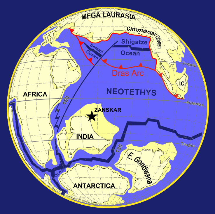
The Tethys Ocean (Ancient Greek: Τηθύς), Tethys Sea or Neotethys was an ocean during much of the Mesozoic Era located between the ancient continents of Gondwana and Laurasia, before the opening of the Indian and Atlantic oceans during the Cretaceous Period.
In 1893, the Austrian geologist
Dr. Eduard Suess (August 1831 – 26 April 1914) proposed the theory that an ancient and extinct inland sea had once existed between Laurasia and the continents which formed Gondwana II. He named it the Tethys Sea after the Greek sea goddess Tethys. He provided evidence for his theory using fossil records from the Alps and Africa. In the following decades during the 20th century, "mobilist" geologists such as Uhlig (1911), Diener (1925), and Daque (1926) regarded Tethys as a large trough between two supercontinents which lasted from the late Palaeozoic until continental fragments derived from Gondwana obliterated it.
From the Ediacaran (600 Mya) into the Devonian (360 Mya), the Proto-Tethys Ocean existed and was situated between Baltica and Laurentia to the north and Gondwana to the south. From the Silurian (440 Mya) through the Jurassic periods, the Paleo-Tethys Ocean existed between the Hunic terranes and Gondwana. Over a period of 400 million years, continental terranes intermittently separated from Gondwana in the Southern Hemisphere to migrate northward to form Asia in the Northern Hemisphere.
About 250 Mya, during the Triassic, a new ocean began forming in the southern end of the Paleo-Tethys Ocean. A rift formed along the northern continental shelf of Southern Pangaea (Gondwana). Over the next 60 million years, that piece of shelf, known as Cimmeria, traveled north, pushing the floor of the Paleo-Tethys Ocean under the eastern end of northern Pangaea (i.e.Laurasia). The Tethys Ocean formed between Cimmeria and Gondwana, directly over where the Paleo-Tethys used to be.
During the Jurassic period about 150 Mya, Cimmeria finally collided with Laurasia and stalled, so the ocean floor behind it buckled under, forming the Tethyan Trench. Water levels rose, and the western Tethys shallowly covered significant portions of Europe, forming the first Tethys Sea. Around the same time, Laurasia and Gondwana began drifting apart, opening an extension of the Tethys Sea between them which today is the part of the Atlantic Ocean between the Mediterranean and the Caribbean. As North and South America were still attached to the rest of Laurasia and Gondwana, respectively, the Tethys Ocean in its widest extension was part of a continuous oceanic belt running around the Earth between about latitude 30°N and the Equator. Thus, ocean currents at the time around the Early Cretaceous ran very differently from the way they do today.
Between the Jurassic and the Late Cretaceous, which started about 100 Mya, Gondwana began breaking up, pushing Africa and India north across the Tethys and opening up the Indian Ocean. As these land masses crowded in on the Tethys Ocean from all sides, to as recently as the Late Miocene, 15 Mya, the ocean continued to shrink, becoming the Tethys Seaway or second Tethys Sea. Throughout the Cenozoic (66 million to the dawn of the Neogene, 23 Mya), global sea levels fell hundreds of meters, and eventually the connections between the Atlantic and the Tethys closed off in what is now the Middle East.
During the Oligocene (33.9 to 23 Mya), large parts of central and eastern Europe were covered by a northern branch of the Tethys Ocean, called the Paratethys. The Paratethys was separated from the Tethys with the formation of the Alps, Carpathians, Dinarides, Taurus, and Elburz mountains during the Alpine orogeny. During the late Miocene, the Paratethys gradually disappeared, and became an isolated inland sea.>>
 Mount Everest Star Trails

