APOD: Japans Kounotori2 Supply Ship the... (2011 Jan 31)

Comments and questions about the APOD on the main view screen.
User avatar
neufer
Vacationer at Tralfamadore
Posts: 18805
Joined: Mon Jan 21, 2008 1:57 pm
Location: Alexandria, Virginia

Re: APOD: Japans Kounotori2 Supply Ship the... (2011 Jan 31)

Post by neufer » Mon Jan 31, 2011 8:51 pm

limb wrote:
".....the limb [sic] of the Earth is visible......"
Well you learn something new every day.
I didn't know the Earth had limbs! That's neat!
(Could it be that the writer was thinking "rim" of the Earth?)
That depends if you are more Anglo-Saxon than Latin:
--------------------------------------------------------
RIM, n. [As. rima, reoma, edge; cf. W. rhim, rhimp, a rim, edge, boundary, termination, Armor, rim. Cf. Rind.]
  • 1. The border, edge, or margin of a thing, usually of something circular or curving; as, the rim of a kettle or basin.

    2. The lower part of the abdomen. [Obs.] Shak.
--------------------------------------------------------
LIMB, n. lim. [L. limbus, edge or border, extremity; limes, limit. The sense of limb is from shooting or extending.] (Webster's 1828)
  • 1. Edge or border. This is the proper signification of the word; but in this sense it is limited chiefly to technical use, and applied to the sun, moon, or a star, to a leaf, to a quadrant, &c. We say, the sun or moon is eclipsed on its northern limb. But we never say, the limb of a board, of a tract of land or water, &c.

    2. In anatomy, and in common use, an extremity of the human body; a member; a projecting part; as the arm or leg; that is, a shoot.

    3. The branch of a tree; applied only to a branch of some size, and not to a small twig.

    4. In botany, the border or upper spreading part of a monopetalous corol.
    --------------------------------------------------------
Art Neuendorffer

slees

Re: APOD: Japans Kounotori2 Supply Ship the... (2011 Jan 31)

Post by slees » Mon Jan 31, 2011 8:57 pm

I would have guessed Africa, but the part of the image that really strikes me is to the lower right of Earth - the formation of clouds and land look for all the world (sorry about the pun) like a wild haired, completely white, 2 eyes, nose, mouth, left arm upraised, right arm sort of folded across the chest.........it even looks like it's wearing a white lab coat! Maybe "he" threw the supply ship up to the ISS??? :P

merlin51

Re: APOD: Japans Kounotori2 Supply Ship the... (2011 Jan 31)

Post by merlin51 » Mon Jan 31, 2011 9:11 pm

Gimwinkle is correct. South Island is clearly visible in Lake Turkana (Rudolph) near the bottom of the photo.

Jharmer

Re: APOD: Japans Kounotori2 Supply Ship the... (2011 Jan 31)

Post by Jharmer » Mon Jan 31, 2011 9:25 pm

Looks pretty big and barren.
Sahara Desert, North Africa.

Scott

Re: APOD: Japans Kounotori2 Supply Ship the... (2011 Jan 31)

Post by Scott » Mon Jan 31, 2011 11:26 pm

The body of water to the left of the Canada boom arm (best visible in the large version of the picture) appears to be the Caspian Sea. The northern end is at the bottom of the picture. The southern end is at the top.

User avatar
Chris Peterson
Abominable Snowman
Posts: 18192
Joined: Wed Jan 31, 2007 11:13 pm
Location: Guffey, Colorado, USA
Contact:

Re: APOD: Japans Kounotori2 Supply Ship the... (2011 Jan 31)

Post by Chris Peterson » Tue Feb 01, 2011 12:00 am

Scott wrote:The body of water to the left of the Canada boom arm (best visible in the large version of the picture) appears to be the Caspian Sea. The northern end is at the bottom of the picture. The southern end is at the top.
There is no doubt at all the lake by the arm is Lake Turkana in Kenya. A view of the Caspian Sea from the ISS would show a much larger apparent size.
Chris

*****************************************
Chris L Peterson
Cloudbait Observatory
https://www.cloudbait.com

stymie

Re: APOD: Japans Kounotori2 Supply Ship the... (2011 Jan 31)

Post by stymie » Tue Feb 01, 2011 12:10 am

The use of limb is quite correct.

Noun limb (plural limbs)

(astronomy) The apparent visual edge of a celestial body.
solar limb

User avatar
neufer
Vacationer at Tralfamadore
Posts: 18805
Joined: Mon Jan 21, 2008 1:57 pm
Location: Alexandria, Virginia

Canadarm Dry Lake

Post by neufer » Tue Feb 01, 2011 1:29 am

Gimwinkle wrote:
Lake Turkana, formerly known as Lake Rudolf, is a lake in the Great Rift Valley in Kenya, with its far northern end crossing into Ethiopia.
It is the world's largest permanent desert lake and the world's largest alkaline lake. This lake can be seen near the Canadarm.
http://en.wikipedia.org/wiki/Lake_Turkana wrote: 
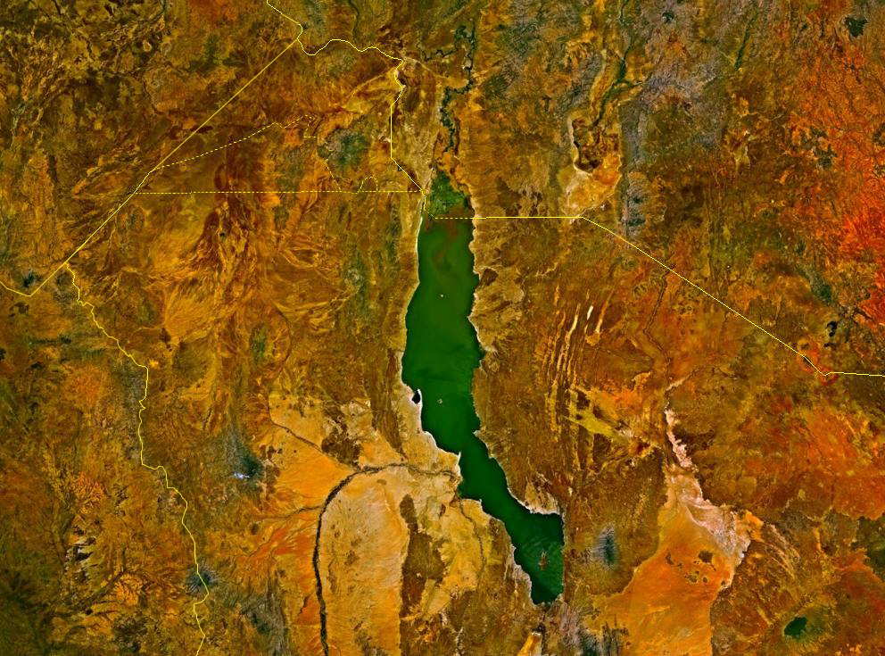
<<Lake Turkana, formerly known as Lake Rudolf, is a lake in the Great Rift Valley in Kenya, with its far northern end crossing into Ethiopia. It is the world's largest permanent desert lake and the world's largest alkaline lake. By volume it is the world's fourth largest salt lake after the Caspian Sea, Issyk-Kul Lake and the (shrinking) Aral Sea. The water is potable but not palatable. It supports a rich lacustrine wildlife. The climate is hot and very dry.
Three rivers (the Omo, Turkwel and Kerio) flow into the lake, but lacking outflow its only water loss is by evaporation. Due to temperature, aridity and geographic inaccessibility, the lake retains its wild character. The rocky shores are home to scorpions and carpet vipers.

The lake formerly contained Africa's largest population of Nile crocodiles: 14,000. The lake also has a large population of large water turtles particularly in the area of Central Island.
Terraces representing ancient shores are visible in the Turkana basin. The highest is 75 m above the surface of the lake (only approximate, as the lake level fluctuates), which was current about 9500 years ago, at the end of the Pleistocene. It is generally theorized that Turkana was part of the upper Nile system at that time, connecting to Lake Baringo at the southern end and the White Nile in the north, and that volcanic land adjustments severed the connection. Such a hypothesis explains the Nile species in the lake, such as the crocodiles and the Nile Perch.

The rocks of the surrounding area are predominantly volcanic. Central Island is an active volcano, emitting vapors. Outcrops and rocky shores are found on the East and South shores of the lake, while dunes, spits and flats are on the West and North, at a lower elevation.

On-shore and off-shore winds can be extremely strong as the lake warms and cools more slowly than the land. Sudden, violent storms are frequent. The Lake Turkana Wind Power consortium plans to provide 300 MW of clean power to Kenya's national electricity grid by tapping the unique wind conditions around the lake. The plan calls for 360 wind turbines, each with a capacity of 850 kilowatts. As of March 2010, the project had found financing, and the Kenyan government will take responsibility for the construction of the transmission lines. If completed, it will become the largest wind power project in Africa.

Around 2 million–3 million years ago, the lake was larger and the area more fertile, making it a centre for early hominins. Richard Leakey has led numerous anthropological digs in the area which have led to many important discoveries of hominin remains. The two-million-year-old Skull 1470 was found in 1972. It was originally thought to be Homo habilis, but the scientific name Homo rudolfensis derived from the old name of the Lake Rudolf, was proposed in 1986 by V. P. Alexeev. In 1984, the Turkana Boy, a nearly complete skeleton of a Homo erectus boy was discovered by Kamoya Kimeu. More recently, Meave Leakey discovered a 3,500,000-year-old skull there, named Kenyanthropus platyops, which means "The Flat-Faced Man of Kenya".

The lake was named Lake Rudolf (in honor of Crown Prince Rudolf of Austria) by Count Sámuel Teleki de Szék and his second-in-command Lieutenant Ludwig Ritter Von Höhnel, a Hungarian and an Austrian, 6 March 1888. They were the first Europeans to have recorded visiting the lake, "finding" it on a large safari across East Africa. At some unknown time the lake became known as the Jade Sea from its turquoise color seen on approaching from a distance. The color comes from algae that rise to the surface in calm weather. This is likely also a European name. The Turkana refer to the lake as anam Ka'alakol, meaning the sea of many fish.>>
Art Neuendorffer

User avatar
Chris Peterson
Abominable Snowman
Posts: 18192
Joined: Wed Jan 31, 2007 11:13 pm
Location: Guffey, Colorado, USA
Contact:

Re: APOD: Japans Kounotori2 Supply Ship the... (2011 Jan 31)

Post by Chris Peterson » Tue Feb 01, 2011 1:41 am

Here's a comparison of two images, today's APOD and an ISS image of Lake Turkana made in September 2000.
turkana_compare.jpg
Chris

*****************************************
Chris L Peterson
Cloudbait Observatory
https://www.cloudbait.com

astromaster

Re: APOD: Japans Kounotori2 Supply Ship the... (2011 Jan 31)

Post by astromaster » Tue Feb 01, 2011 4:44 am

Greetings: Kenya and Ethiopia!

Scott

Re: APOD: Japans Kounotori2 Supply Ship the... (2011 Jan 31)

Post by Scott » Tue Feb 01, 2011 6:11 am

After reading the replies of Chris Peterson and Art Neuendorffer to my post and examining the photos and other research material they provided, I've concluded that I was wrong about my idea that the Caspian Sea was depicted in the 2011 January 31 APOD. I made my post during a brief break at work, and when I got home I compared their material with the Satellite World Atlas (Helicon Publishing). I noticed that the shoreline of Lake Turkana as depicted in the atlas is a much better match for the photos provided by Chris and Art than the shoreline of the Caspian Sea. Thanks, gentlemen. Good catch and very good research.

BrisbanePeter

Re: APOD: Japans Kounotori2 Supply Ship the... (2011 Jan 31)

Post by BrisbanePeter » Tue Feb 01, 2011 7:03 am

Is it Uzbekistan and the Aral sea?

JustMe

Re: APOD: Japans Kounotori2 Supply Ship the... (2011 Jan 31)

Post by JustMe » Wed Feb 02, 2011 5:44 pm

It seems most postings have pointed to the area of water near the boom, while there are distinctive lakes to the upper right of Kounotori2. Using your mapping site of choice, these lakes are easily seen to the SSW of Adama, Etheopia, or due south of Addis Ababa, Ethiopia.

Post Reply