APOD Collection: Hurricanes/Tropical Cyclones
APOD Collection: Hurricanes/Tropical Cyclones
Hurricanes/Tropical Cyclones
All titles are clickable and link to the original APOD page. Click on an image for a larger view of it.
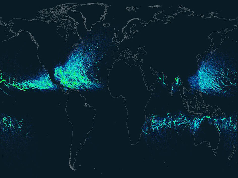
2012 September 4 Should you be worried about hurricanes? To find out, it is useful to know where hurricanes have gone in the past. The above Earth map shows the path of every hurricane reported since 1851, Although striking, a growing incompleteness exists in the data the further one looks back in time. The above map graphically indicates that hurricanes -- sometimes called cyclones or typhoons depending on where they form -- usually occur over water, which makes sense since evaporating warm water gives them energy. The map also shows that hurricanes never cross -- or even occur very near -- the Earth's equator, since the Coriolis effect goes to zero there, and hurricanes need the Coriolis force to circulate. The Coriolis force also causes hurricane paths to arc away from the equator. Although incompleteness fogs long term trends and the prevalence of hurricanes remains a topic of research, evidence is accumulating that hurricanes are, on the average, more common and more powerful in the North Atlantic Ocean over the past 20 years.
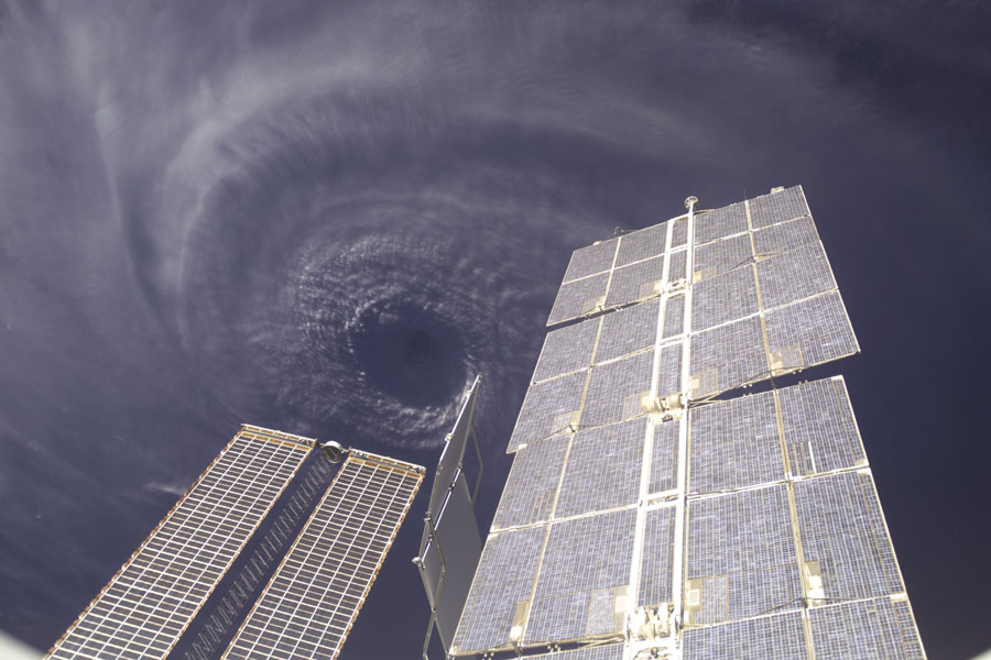
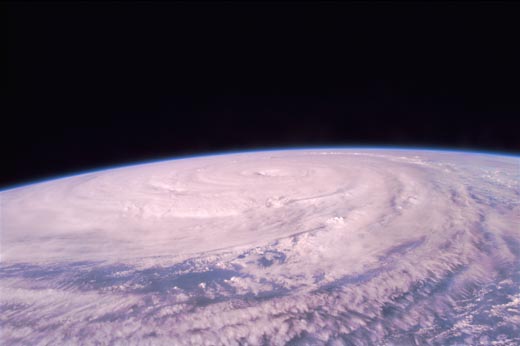
2008 January 13 Ninety percent of the houses on Grenada were damaged by the destructive force of Hurricane Ivan. At its peak, Ivan was a Category 5 hurricane, the highest power category on the Saffir-Simpson Scale, and created sustained winds in excess of 200 kilometers per hour. Ivan was the largest hurricane to strike the US in 2004, and, so far, the 10th most powerful in recorded history. As it swirled in the Atlantic Ocean, the tremendous eye of Hurricane Ivan was photographed from above by the orbiting International Space Station. The name Ivan has now been retired from Atlantic Ocean use by the World Meteorological Organization.
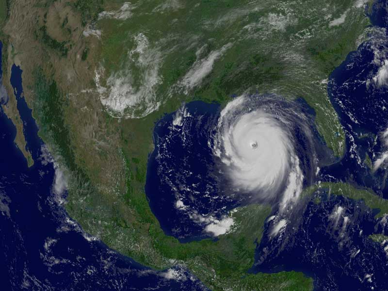
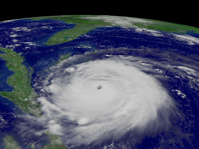
2005 August 29 Where will Hurricane Katrina go? One of the stronger storm systems of modern times appears headed for landfall somewhere in the southern USA sometime today. Katrina was designated yesterday a rare Category 5 Hurricane, the strongest designation for a storm on Earth, and one that indicates sustained winds greater than 250 kilometers per hour. Pictured above is a digitally processed image from the orbiting GOES-12 weather satellite that shows the massive storm system yesterday in the Gulf of Mexico. Starting as a slight pressure difference, hurricanes grow into large spiraling storm systems of low pressure, complete with high winds and driving rain. A hurricane is powered by evaporating ocean water, and so typically gains strength over warm water and loses strength over land. Much remains unknown about hurricanes and cyclones, including how they are formed and the exact path they will take.
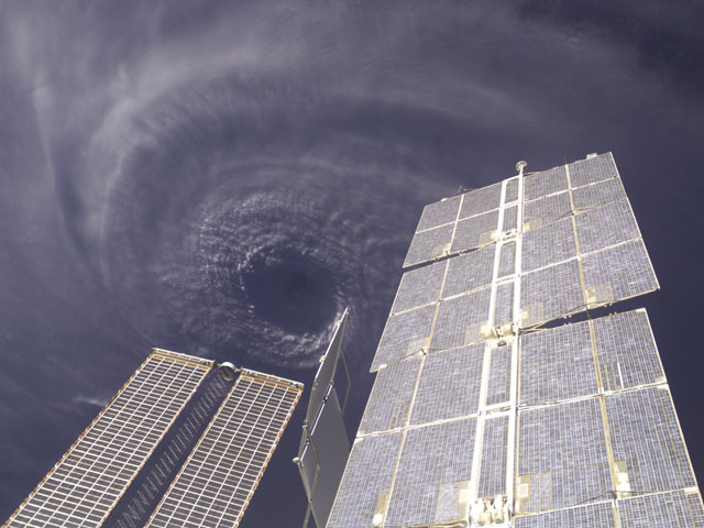
2004 September 15 Ninety percent of the houses on Grenada were damaged. Such is the destructive force of Hurricane Ivan, already one of the most powerful and destructive hurricanes on record. And the storm will likely make landfall in southern USA tomorrow. Ivan is the currently the third - and largest - hurricane set to strike the US this hurricane season. The swirling eye of Hurricane Ivan was photographed above from the orbiting International Space Station (ISS) on Saturday as the storm's sustained 200 kilometer per hour winds wreaked havoc in the Caribbean. The bad news is that hurricane season in the Atlantic typically lasts until November 30, still over two months away. The more immediate bad news is that tropical storm Jeanne is next in line coming across the mid-Atlantic Ocean and could pass Puerto Rico sometime today.
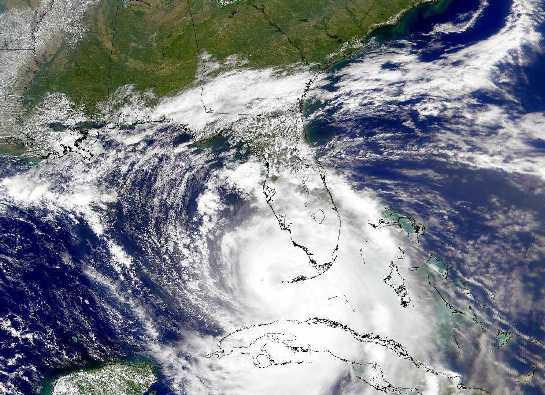
2004 September 3 A major hurricane is heading for Florida. Hurricane Frances, one of the stronger storm systems of modern times, may cross the eastern coast of Florida sometime tomorrow. Those in the path of a hurricane should take precautions. For example, NASA's Kennedy Space Center has completely shut down. The orbiting GOES-12 satellite took the above image of Hurricane Frances early yesterday. Hurricanes are huge swirling storms with cloud systems typically larger than a state. Tropical cyclones, called hurricanes in Earth's Western Hemisphere and typhoons in the Eastern Hemisphere, get their immense energy from warm evaporated ocean water. As this water vapor cools and condenses, it heats the air, lowers pressure and hence causes cooler air to come swooshing in. Winds can reach over 250 kilometers per hour and become very dangerous. Much remains unknown about cyclones, including how they are formed and the exact path they will take.
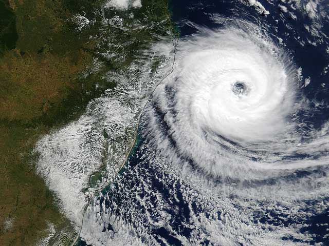
2004 April 6 How did this huge cyclone form? An unusually strong storm -- perhaps the strongest storm in the recorded history of the South Atlantic Ocean -- crossed the coast of Brazil last week. Cyclones this powerful, classified by some as the first ever Category 1 Hurricane, are very rare in the South Atlantic. Tropical cyclones are large regions of low pressure with little vertical wind shear that typically form over regions of warm water, which power the cyclone through evaporation. Reports of relatively cold air in the center indicate, however, that this storm was extratropical. The storm was dubbed Caterina by local meteorologists, although no formal naming precedents exist in this part of the world.
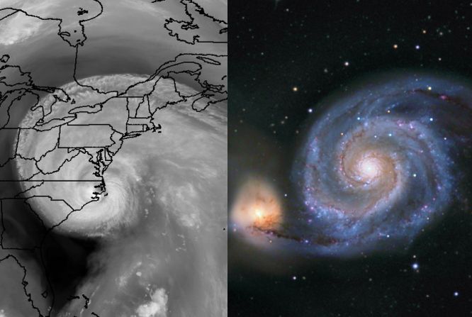
2003 September 25 Uncomfortably close hurricane Isabel (left) and 30 million light-year distant galaxy M51 actually don't have much in common. For starters, Isabel was hundreds of miles across, while M51 (the Whirlpool Galaxy) spans about 50,000 light-years making them vastly dissimilar in scale, not to mention the extremely different physical interactions which control their formation and evolution. But they do look amazingly alike, both exhibiting the shape of a simple and beautiful mathematical curve known as a logarithmic spiral, a spiral whose separation grows in a geometric way with increasing distance from the center. Also known as the equiangular spiral, growth spiral, and Bernoulli's spiral or spira mirabilis, this curve's rich properties have fascinated mathematicians since its discovery by 17th century philosopher Descartes. Intriguingly, this abstract shape is much more abundant in nature than suggested by the striking visual comparison above. Logarithmic spirals also describe, for example, the arrangement of sunflower seeds, the shapes of nautilus shells, and ... cauliflower.
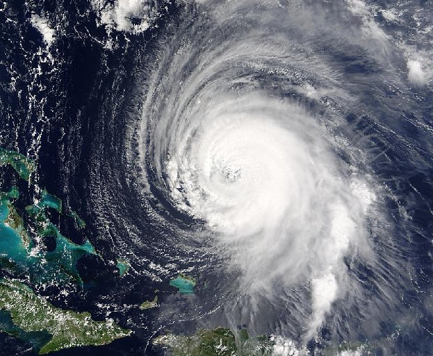
2003 September 16 Where will Hurricane Isabel go? One of the stronger storm systems of modern times appears headed for one the more populated seaboards on planet Earth -- the east coast of the USA. Hurricane Isabel, pictured yesteday as it passed east of the Bahamas, has flirted with category 5 status, the most powerful hurricane category. Hurricanes are huge swirling storms with cloud systems typically larger than a state. Tropical cyclones, called hurricanes in Earth's Western Hemisphere and typhoons in the Eastern Hemisphere, get their immense energy from warm evaporated ocean water. As this water vapor cools and condenses, it heats the air, lowers pressure and hence causes cooler air to come swooshing in. Winds can reach over 250 kilometers per hour and become very dangerous. Much remains unknown about cyclones, including how they are formed and the exact path they will take.
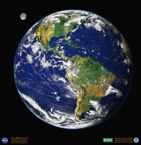
2000 April 20 This newly released digital portrait of our planet is reminiscent of the Apollo-era pictures of the "big blue marble" Earth from space. To create it, researchers at Goddard Space Flight Center's Laboratory for Atmospheres combined data from a Geostationary Operational Environmental Satellite (GOES), the Sea-viewing Wide Field-of-view Sensor (SeaWiFS), and the Polar Orbiting Environmental Satellites (POES) with a USGS elevation model of Earth's topography. Stunningly detailed, the planet's western hemisphere is cast so that heavy vegetation is green and sparse vegetation is yellow, while the heights of mountains and depths of valleys have been exaggerated by 50 times to make vertical relief visible. Hurricane Linda is the dramatic storm off North America's west coast. And what about the Moon? The lunar image was reconstructed from GOES data and artistically rescaled for this visualization.
September 28, 1998 Last Friday, Hurricane Georges was photographed from space entering the Gulf of Mexico. This immense storm system, larger than most states, is expected to make landfall today. Starting as a slight pressure difference, hurricanes grow into large spiraling storm systems of low pressure, complete with high winds and driving rain. A hurricane is powered by evaporating ocean water, and so typically gains strength over warm water and loses strength over land. Currently offshore in the Atlantic Ocean, Hurricanes Ivan, Jeanne, and Karl swirl, but will likely stay well away from North America.
August 19, 1997 Super Typhoon Winnie raged through parts of the Eastern Hemisphere last week. Swirling in the Pacific Ocean with winds in excess of 160 miler per hour, Winnie became one of the stronger storm systems in modern times: a Category 5 Hurricane. The above picture, taken August 13th by crew member of Space Shuttle Discovery, showed the extent of this huge storm: the central eye measured fully 8 miles in diameter. Last week, Winnie hit the Northern Mariana Islands at full strength, but then weakened before heading toward China. Studying large storms systems on other planets give insight into the workings of Earth bound storms like Winnie.
September 20, 1996 Two weeks ago Hurricane Fran, pictured above, struck the east coast of the United States. Hurricanes are huge swirling storms with cloud systems typically larger than a state. Tropical cyclones, called Hurricanes in Earth's Western Hemisphere and Typhoons in the Eastern Hemisphere, get their immense energy from warm evaporated ocean water. As this water vapor cools and condenses, it heats the air, lowers pressure and hence causes cooler air to come swooshing in. Winds can reach over 150 miles per hour and become very dangerous. Hurricane Fran, for example, killed more than 30 people and destroyed many million of dollars worth of property. Much remains unknown about cyclones, including how they are formed and the exact path they will take.
A closed mouth gathers no foot.