Page 1 of 2
APOD: Hurricane Paths on Planet Earth (2012 Sep 04)
Posted: Tue Sep 04, 2012 4:06 am
by APOD Robot
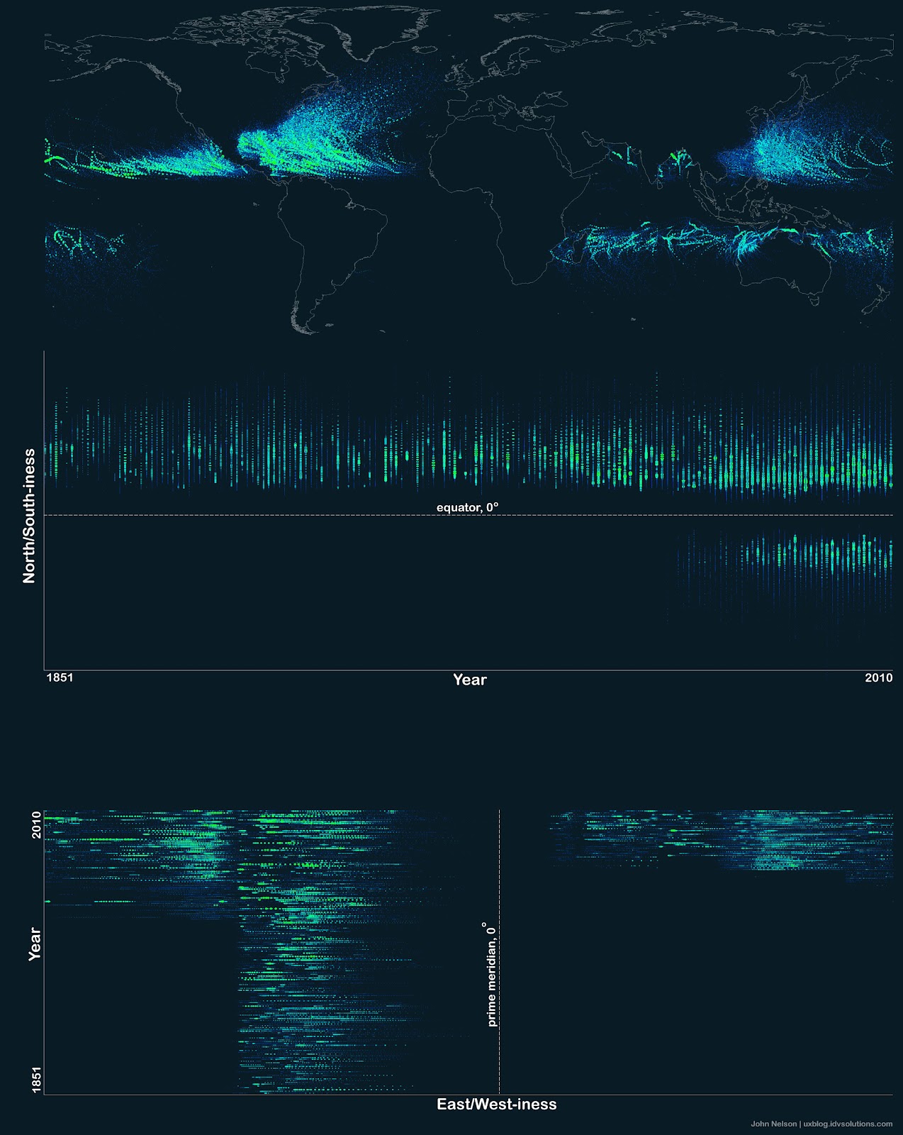
 Hurricane Paths on Planet Earth
Explanation:
Hurricane Paths on Planet Earth
Explanation: Should you be worried about hurricanes? To find out, it is useful to know where
hurricanes have gone in the past. The
above Earth map shows the path of every
hurricane reported since 1851, Although striking, a growing incompleteness exists in the data the further one looks back in time. The
above map graphically indicates that hurricanes -- sometimes called cyclones or typhoons depending on where they
form -- usually occur over water, which makes sense since evaporating warm water
gives them energy. The
map also shows that hurricanes never cross -- or even occur very near -- the
Earth's equator, since the
Coriolis effect goes to zero there, and hurricanes need the Coriolis force to circulate. The
Coriolis force also causes
hurricane paths to arc away from the equator. Although incompleteness fogs long term trends and the
prevalence of hurricanes remains a topic of research, evidence is accumulating that hurricanes are, on the average,
more common and more powerful in the North Atlantic Ocean over the past 20 years.
[/b]
Re: APOD: Hurricane Paths on Planet Earth (2012 Sep 04)
Posted: Tue Sep 04, 2012 4:19 am
by bystander
Re: APOD: Hurricane Paths on Planet Earth (2012 Sep 04)
Posted: Tue Sep 04, 2012 4:46 am
by Boomer12k
Just because we don't worry about Hurricanes does not mean we have nothing to worry about in the Pacific Northwest. We don't usually worry about Tornadoes, but one tore up a nearby town a couple of years ago...the first I have ever heard of one touching down in my area, and I am 59. We don't get a Hurricane, but we get 80-120 MPH winds, and cyclonic wave action off the Pacific Ocean. The 1962 Columbus Day storm is still remembered.
We also get Ice Storms, and snow storms one a decade or so. Bad flooding and such too...we can have drought and bad fire seasons, and even small, but damaging Earthquakes, And Mt. St. Helens erupted in 1980....PLENTY TO WORRY ABOUT!!!

But tonight is nice and pleasant and I am typing this while at the telescope.

So, regardless of your troubles, I want my APOD friends to be WELL AND HAPPY!!! Safe and Sound.
:---[===]*
Re: APOD: Hurricane Paths on Planet Earth (2012 Sep 04)
Posted: Tue Sep 04, 2012 4:54 am
by Ann
Thanks, Boomer12k! You too, and everyone else too.
Ann
Re: APOD: Hurricane Paths on Planet Earth (2012 Sep 04)
Posted: Tue Sep 04, 2012 5:18 am
by tjjharris
The hurricane tracks page says "every" hurricane. In the way most people look for themselves in a group portrait, I look first for the track of the hurricanes which have hit my home. I live in Hawaii, and we've had only two, and recently at that, yet I see no hurricane tracks in the pacific which come up to Hawaii. Hurricane Iniki moved almost due west, and then when due south of us, came right up to smash Lihue, Kauai, "eye on". They're still rebuilding. No track for Iniki seen however. Maybe it's just too faint to see?
Re: APOD: Hurricane Paths on Planet Earth (2012 Sep 04)
Posted: Tue Sep 04, 2012 8:41 am
by workgazer
Am i missing something, why are there no Huricaines / cyclones in the south atlantic? large body of warm open water yet they do not appear
help
Re: APOD: Hurricane Paths on Planet Earth (2012 Sep 04)
Posted: Tue Sep 04, 2012 11:13 am
by rhapsody58
The map is also missing at least one other track. In 2004, hurricane Catarina hit Brazil, the first South Atlantic storm on record to be strong enough to reach hurricane level. South Atlantic tropical cyclones are rare, as atmospheric conditions are much different than those in the North.
Re: APOD: Hurricane Paths on Planet Earth (2012 Sep 04)
Posted: Tue Sep 04, 2012 1:39 pm
by biddie67
It looks like if the land mass of the North American continent weren't there to deflect hurricanes that the Asian coastline would get a lot more bad storms.
Re: APOD: Hurricane Paths on Planet Earth (2012 Sep 04)
Posted: Tue Sep 04, 2012 1:47 pm
by neufer
workgazer wrote:
Am i missing something, why are there no Huricaines / cyclones in the south atlantic? large body of warm open water yet they do not appear
There is
great asymmetry in North/South Geography
that strongly affects ocean currents.

The strong cold Antarctic Circumpolar Current is unimpeeded by large continents except for South America & South Africa which slice off cold Peru & Benguela Currents.
These strong cold upwelling currents run all the way up to the Equator preventing cyclones from developing in the South Atlantic or Southeast Pacific.
The weaker & warmer California & Canary Currents:
- 1) are fed by strong warm Kuroshio & Gulf Stream waters
2) and do not penetrate all the way down to the Equator.
Re: APOD: Hurricane Paths on Planet Earth (2012 Sep 04)
Posted: Tue Sep 04, 2012 1:54 pm
by grover
As this appears to be a regurgitation of John Nelson's recently newsed map, the discussion is lacking the disclaimer that his mapping data was incomplete as the US did not really collect Hurricane tracking data for the east and south hemisphere until 1978.
http://uxblog.idvsolutions.com/2012/08/ ... -1851.html
Re: APOD: Hurricane Paths on Planet Earth (2012 Sep 04)
Posted: Tue Sep 04, 2012 2:06 pm
by emc
Unabashed fractured fiction…
The word hurricane comes from the Carib Indians of the West Indies. They had to hurry in order to harvest their sugar cane crop before the storm season hit.
Re: APOD: Hurricane Paths on Planet Earth (2012 Sep 04)
Posted: Tue Sep 04, 2012 2:12 pm
by Chris Peterson
tjjharris wrote:The hurricane tracks page says "every" hurricane. In the way most people look for themselves in a group portrait, I look first for the track of the hurricanes which have hit my home. I live in Hawaii, and we've had only two, and recently at that, yet I see no hurricane tracks in the pacific which come up to Hawaii. Hurricane Iniki moved almost due west, and then when due south of us, came right up to smash Lihue, Kauai, "eye on". They're still rebuilding. No track for Iniki seen however. Maybe it's just too faint to see?
I see at least two tracks in the cluster of events around Hawaii that show the west-then-north "L" shape of Iniki's path, including one that looks exactly like this. Are you looking at the full sized image?
Re: APOD: Hurricane Paths on Planet Earth (2012 Sep 04)
Posted: Tue Sep 04, 2012 2:23 pm
by neufer
biddie67 wrote:
It looks like if the land mass of the North American continent weren't there to deflect hurricanes
that the Asian coastline would get a lot more bad storms.
If the land mass of the North American continent weren't there to deflect hurricanes
the
Hawaiian coastline would certainly get a lot more bad storms.
However, this APOD only displays the most recent (satellite monitored) Pacific typhoons.
(A complete display of Pacific typhoons would overwhelm the visual.)
Pacific typhoons dwarf Atlantic hurricanes in both number & intensity
(and they could really care less about the North American continent).
http://en.wikipedia.org/wiki/Typhoon#Frequency wrote:
<<
Nearly one-third of the world's tropical cyclones form within the western Pacific. This makes this basin the most active on Earth. Pacific typhoons have formed year round, with peak months from August to October. The peak months correspond to that of the Atlantic hurricane seasons.
Along with a high storm frequency, this basin also features the most globally intense storms on record. One of the most recent busy seasons was 2004. Tropical cyclones form in any month of the year across the northwest Pacific ocean, and concentrate around June and November in the northern Indian ocean. The area just northeast of the Philippines is the most active place on Earth for tropical cyclones to exist. Across the Philippines themselves, activity reaches a minimum in February, before increasing steadily through June, and spiking from July through October, with September being the most active month for tropical cyclones across the archipelago. Activity falls off significantly in November. The most frequently impacted areas of the Philippines by tropical cyclones are northern Luzon and eastern Visayas. A ten year average of satellite determined precipitation showed that at least 30 percent of the annual rainfall in the northern Philippines could be traced to tropical cyclones, while the southern islands receive less than 10 percent of their annual rainfall from tropical cyclones.>>
Re: APOD: Hurricane Paths on Planet Earth (2012 Sep 04)
Posted: Tue Sep 04, 2012 2:50 pm
by StarDawg
Usually, APOD is all about astronomy. Today, I am trying to figure out if the author of the comments on today's "photograph" is myopic, and doesn't see the global trends,

or has some other hidden agenda:

APOD Robot wrote: Hurricane Paths on Planet Earth
... evidence is accumulating that hurricanes are, on the average, more common and more powerful in the North Atlantic Ocean over the past 20 years.
The chart in the full-sized image clearly shows that there was a more pronounced global increase in strength roughly 60 or 70 years ago, lasting about 20 years followed by a slight pause of just a couple of years, becoming more common and more powerful over the past 40 years.

Re: APOD: Hurricane Paths on Planet Earth (2012 Sep 04)
Posted: Tue Sep 04, 2012 3:08 pm
by Chris Peterson
StarDawg wrote:Usually, APOD is all about astronomy.
As it is today. Global climate change has driven our rapid increase in knowledge about climate systems in general, and has resulted in high quality climate modeling tools which are useful not just for looking at Earth, but in looking at climate and weather systems on other planets, as well... this, just as we are seeing an explosion of observational data from other planets.
First and foremost, our understanding of what is happening on other planets starts with our understanding of things on Earth: geology, tectonics, atmospherics, oceans, climate... you name it. All of these "Earth sciences" form the basis of planetary science in general.
Re: APOD: Hurricane Paths on Planet Earth (2012 Sep 04)
Posted: Tue Sep 04, 2012 3:28 pm
by Psnarf
The sky is falling! It's a disaster of biblical proportions. Human sacrifice, dogs and cats living together... mass hysteria! [apologies to "Ghost Busters"] Go find your helmet; put your helmet on.
http://ngm.nationalgeographic.com/2012/ ... iller-text
Re: APOD: Hurricane Paths on Planet Earth (2012 Sep 04)
Posted: Tue Sep 04, 2012 5:44 pm
by Fafers
rhapsody58 wrote:The map is also missing at least one other track. In 2004, hurricane Catarina hit Brazil, the first South Atlantic storm on record to be strong enough to reach hurricane level. South Atlantic tropical cyclones are rare, as atmospheric conditions are much different than those in the North.
If you look closely, you will find Catarina's path just off the brazilian southern coast.
Re: APOD: Hurricane Paths on Planet Earth (2012 Sep 04)
Posted: Tue Sep 04, 2012 6:55 pm
by do_japan
Why is there no record of Hurricanes/Typhoons in the southern hemisphere before 1950?
Re: APOD: Hurricane Paths on Planet Earth (2012 Sep 04)
Posted: Tue Sep 04, 2012 8:39 pm
by neufer
do_japan wrote:
Why is there no record of Hurricanes/Typhoons in the southern hemisphere before 1950?
The further back one goes in time the less accurate the records get(, especially out of the main shipping lanes).
A display (such as this one) of global distribution works best when limited to a modern accurate sampling.
Re: APOD: Hurricane Paths on Planet Earth (2012 Sep 04)
Posted: Tue Sep 04, 2012 9:12 pm
by Moonlady
Boomer12k wrote:Just because we don't worry about Hurricanes does not mean we have nothing to worry about in the Pacific Northwest. We don't usually worry about Tornadoes, but one tore up a nearby town a couple of years ago...the first I have ever heard of one touching down in my area, and I am 59. We don't get a Hurricane, but we get 80-120 MPH winds, and cyclonic wave action off the Pacific Ocean. The 1962 Columbus Day storm is still remembered.
We also get Ice Storms, and snow storms one a decade or so. Bad flooding and such too...we can have drought and bad fire seasons, and even small, but damaging Earthquakes, And Mt. St. Helens erupted in 1980....PLENTY TO WORRY ABOUT!!!
But tonight is nice and pleasant and I am typing this while at the telescope.
So, regardless of your troubles, I want my APOD friends to be WELL AND HAPPY!!! Safe and Sound.
:---[===]*
Lets all move to equator!
Boomer your telescope is connected with your pc? What kind of telescope do you use?
:usual complain insert: Todays APOD is not about astronomic picture!

Re: APOD: Hurricane Paths on Planet Earth (2012 Sep 04)
Posted: Wed Sep 05, 2012 2:10 am
by GerryP
tjjharris wrote:The hurricane tracks page says "every" hurricane. In the way most people look for themselves in a group portrait, I look first for the track of the hurricanes which have hit my home. I live in Hawaii, and we've had only two, and recently at that, yet I see no hurricane tracks in the pacific which come up to Hawaii. Hurricane Iniki moved almost due west, and then when due south of us, came right up to smash Lihue, Kauai, "eye on". They're still rebuilding. No track for Iniki seen however. Maybe it's just too faint to see?
I zoomed in on Hawaii on the APOD and saw a track that looked like Iniki's track as listed on Wikipedia. It was hard to tell as the image got very blurry. Life on Hawaii is often portrayed as a great big paradise. Our thoughts and prayers are with those that are rebuilding after Iniki.
Re: APOD: Hurricane Paths on Planet Earth (2012 Sep 04)
Posted: Wed Sep 05, 2012 4:55 am
by Stephen Rasey
In the classic book, “How to Lie with Maps”, it begins with the line, “Not only is it easy to lie with maps, it is essential”.
You see, any map is at best a reduced form of reality. The curve of a sphere projected onto a plane. Towns simplified to dots. Labels where none exist. A map is filled with lies. The trick in making a
good map is to commit only “white lies”. White lies do not distort the basic truths and relationships that are the subject of the map. White Lies add clarity, including being clear about what we don't know: Terra Incognita.
The subject hurricane history map in today’s APOD fails this White Lie test. It purports to show "every hurricane reported" since 1851. That begs the question, "Reported to whom?" Did the author get every hurricane reported by every ship’s captain? If so, why does the Australia region of the map look so very different from the one provided by the Australian government?
http://www.bom.gov.au/cgi-bin/silo/cycl ... =all&loc=0
As grover pointed out above
the US did not really collect Hurricane tracking data for the east and south hemisphere until 1978.
So it is necessary to be skeptical of this map. It represents uneven data collection probably more than tells up about the distribution of hurricanes. There are more hurricanes plotted in the north Atlantic portion of the map because the US was looking for them there longer, and intently after Galveston 1900.
Re: APOD: Hurricane Paths on Planet Earth (2012 Sep 04)
Posted: Wed Sep 05, 2012 5:25 am
by Chris Peterson
Stephen Rasey wrote:The subject hurricane history map in today’s APOD fails this White Lie test. It purports to show "every hurricane reported" since 1851. That begs the question, "Reported to whom?" Did the author get every hurricane reported by every ship’s captain? If so, why does the Australia region of the map look so very different from the one provided by the Australian government?
http://www.bom.gov.au/cgi-bin/silo/cycl ... =all&loc=0
As grover pointed out above
the US did not really collect Hurricane tracking data for the east and south hemisphere until 1978.
So it is necessary to be skeptical of this map. It represents uneven data collection probably more than tells up about the distribution of hurricanes. There are more hurricanes plotted in the north Atlantic portion of the map because the US was looking for them there longer, and intently after Galveston 1900.
No, it is not necessary to be skeptical of this map at all. It is important to understand the nature of the underlying dataset (which is explained in great detail at the NOAA site for the data maintainers). It is also necessary to know which subsets of the data were used for the plot.
The purpose of the map is not to provide quantitative analysis- that can be done using the original data, and can fully allow for the various uncertainties (which typically increase as the data gets older). The purpose of the map is to provide a qualitative feel for where hurricanes occur- how they are affected by ocean and land, by latitude, and the effect of the equator. The map succeeds very well in this goal. Qualitatively, it is unlikely the map would look any different if every plotted storm had its path known with 100% accuracy.
Re: APOD: Hurricane Paths on Planet Earth (2012 Sep 04)
Posted: Wed Sep 05, 2012 9:48 am
by owlice
Off-topic discussion moved
here.
Re: APOD: Hurricane Paths on Planet Earth (2012 Sep 04)
Posted: Wed Sep 05, 2012 3:05 pm
by Stephen Rasey
Something else missing from this map are
the polar cyclones.
You can reply, "Yes, but this is a hurricane map and hurricanes are tropical." True, but if the point of the map, as stated in the original description is:
Should you be worried about hurricanes? To find out, it is useful to know where hurricanes have gone in the past. If hurricanes must be tropical, then "where they have gone" is a bit tautological.
“The most powerful storm to affect the Bering Sea coast of Alaska in 37 years is pounding Alaska’s west coast and Eastern Siberia with hurricane-force winds, a destructive storm surge up to 7 feet high, waves up to 35 feet high, and blinding snow,” ...." central pressure of 945 mb." ... "6 foot storm surge in Nome Alaska." -- November 8-9, 2011.
That sounds like a "hurricane" to me. A polar cyclone, but a hurricane by another name. Should storms like these be on the map? It depends on what you want the map to show. If
is useful to know where hurricanes have gone in the past, then I wonder what that big black areas north of Antarctica, around Alaska, and between Iceland and Murmansk ought to look like with polar cyclones included.

