Page 1 of 3
APOD: Equinox Earth (2013 Sep 28)
Posted: Sat Sep 28, 2013 4:06 am
by APOD Robot
 Equinox Earth
Explanation:
Equinox Earth
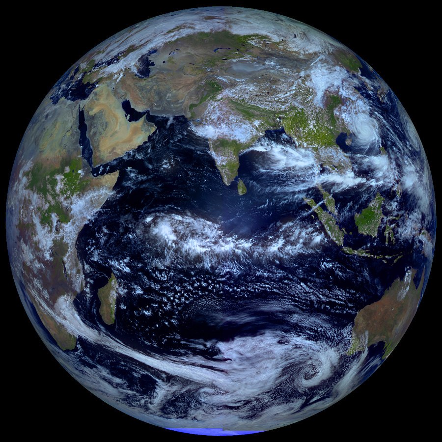
Explanation: From a geostationary orbit 36,000 kilometers above the equator, Russian meteorological
satellite Elektro-L takes high-resolution images
our fair planet every 30 minutes. But only twice
a year, during an Equinox, can it capture an image like this one, showing an entire hemisphere bathed in sunlight.
At an Equinox, the Earth's axis of rotation is not tilted toward or away from the Sun, so the
solar illumination can extend to both the planet's poles. Of course, this
Elektro-L picture was recorded on September 22nd, at the northern hemisphere's autumnal equinox. For a moment on that date, the Sun was behind the
geostationary satellite and a telltale glint of reflected sunlight is seen crossing the equator, at the location on the planet with satellite and sun directly overhead (
5MB animated gif).
[/b]
Re: APOD: Equinox Earth (2013 Sep 28)
Posted: Sat Sep 28, 2013 5:20 am
by alter-ego
Ok, I must confess. I'm so used to Google that I went to spin the Earth and realized that doesn't work here...
Re: APOD: Equinox Earth (2013 Sep 28)
Posted: Sat Sep 28, 2013 6:12 am
by Boomer12k
I am amazed at how little GREEN there is....Rising seas not withstanding...are we headed toward Desert Earth???
Really nice picture...everything is sharp and clear.
:---[===] *
Re: APOD: Equinox Earth (2013 Sep 28)
Posted: Sat Sep 28, 2013 6:28 am
by geckzilla
Boomer12k wrote:I am amazed at how little GREEN there is....Rising seas not withstanding...are we headed toward Desert Earth???
Really nice picture...everything is sharp and clear.
:---[===] *
It's a combination visible and near infrared image so the colors are not natural. But Earth really is full of deserts and mountains and stuff not bright happy green, especially when you are peering down at the Sahara and Himalayas.
Re: APOD: Equinox Earth (2013 Sep 28)
Posted: Sat Sep 28, 2013 7:24 am
by SouthEastAsia
Boomer12k wrote:
I am amazed at how little GREEN there is....Rising seas not withstanding...are we headed toward Desert Earth???
Really nice picture...everything is sharp and clear.
Since the beginning of time, there has been a constant state of expanding and shrinking deserts on Earth. Even today, with the added influence of mankind contributing busily to our global environs, there are apparently deserts which are shrinking and some forming.
With respect to actual 'greening' however, it might be interesting to consider 'Greenland', which is curiously becoming yes, more GREEN! Perhaps though, not as green as she was around 120,000 years ago when avg temps were estimated at around 9F warmer...
Re: APOD: Equinox Earth (2013 Sep 28)
Posted: Sat Sep 28, 2013 7:59 am
by Uwe
Thanks (once again) for a great picture! Amazing animation too!
")
Re: APOD: Equinox Earth (2013 Sep 28)
Posted: Sat Sep 28, 2013 9:05 am
by Ann
Boomer12k wrote:I am amazed at how little GREEN there is....Rising seas not withstanding...are we headed toward Desert Earth???
Really nice picture...everything is sharp and clear.
:---[===] *
Much of the land we see here is typical arid or desert country. That is why it is not cloud-covered, and we see it so well.
Ann
Re: APOD: Equinox Earth (2013 Sep 28)
Posted: Sat Sep 28, 2013 10:10 am
by zbvhs
And somewhere down there, if you knew exactly where to look, you would see the satellite's shadow.
Re: APOD: Equinox Earth (2013 Sep 28)
Posted: Sat Sep 28, 2013 11:22 am
by neufer
zbvhs wrote:
And somewhere down there, if you knew exactly where to look, you would see the satellite's shadow.
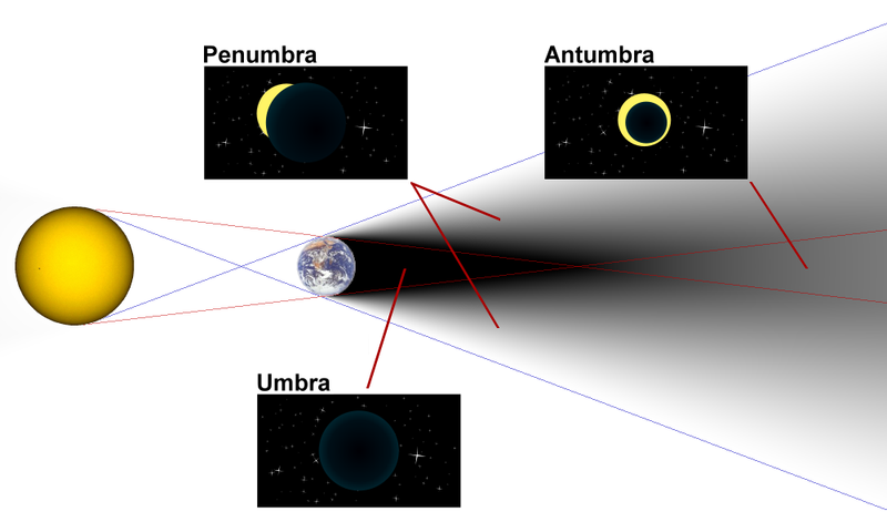
- By "shadow" do you mean the penumbra or the antumbra, exactly

http://en.wikipedia.org/wiki/Umbra wrote:
<<The umbra, penumbra and antumbra are three distinct parts of a shadow, created by any light source after impinging on an opaque object. For a point source only the umbra is cast.
These names are most often used for the shadows cast by celestial bodies, though they are sometimes used to describe levels of darkness, such as in sunspots.
The umbra (Latin for "shadow") is the innermost and darkest part of a shadow, where the light source is completely blocked by the occluding body. An observer in the umbra experiences a total eclipse.
The penumbra (from the Latin paene "almost, nearly" and umbra "shadow") is the region in which only a portion of the light source is obscured by the occluding body. An observer in the penumbra experiences a partial eclipse. An alternative definition is that the penumbra is the region where some or all of the light source is obscured (i.e., the umbra is a subset of the penumbra). For example, NASA's Navigation and Ancillary Information Facility defines that a body in the umbra is also within the penumbra.
The antumbra (from Latin ante, 'before') is the region from which the occluding body appears entirely contained within the disc of the light source. If an observer in the antumbra moves closer to the light source, the apparent size of the occluding body increases until it causes a full umbra. An observer in this region experiences an annular eclipse, in which a bright ring is visible around the eclipsing body.>>
Re: APOD: Equinox Earth (2013 Sep 28)
Posted: Sat Sep 28, 2013 11:30 am
by Skasi
Re: APOD: Equinox Earth (2013 Sep 28)
Posted: Sat Sep 28, 2013 11:46 am
by Gary Loeb
The description says 'northern hemisphere's Autumnial Equinox'. It's the whole Earth's Autumnal Equinox!!!
Re: APOD: Equinox Earth (2013 Sep 28)
Posted: Sat Sep 28, 2013 11:55 am
by Gary Loeb
Gary Loeb wrote:The description says 'northern hemisphere's Autumnial Equinox'. It's the whole Earth's Autumnal Equinox!!!
I just realized my minor mistake... It IS the northern hemisphere's autumnal equinox, as well as the southern hemisphere's vernal equinox. It's the Whole Earth's equinox.

Infernal Equinox
Posted: Sat Sep 28, 2013 12:28 pm
by neufer
Gary Loeb wrote:
I just realized my minor mistake... It IS the northern hemisphere's autumnal equinox,
as well as the southern hemisphere's vernal equinox. It's the Whole Earth's equinox.
You would think that they would have come up with better names by now.
Re: APOD: Equinox Earth (2013 Sep 28)
Posted: Sat Sep 28, 2013 12:46 pm
by retrogalax
If i was an Extra-Terrestrial i would love to own this planet. Nice educational picture.

Re: APOD: Equinox Earth (2013 Sep 28)
Posted: Sat Sep 28, 2013 1:36 pm
by Eric
Great pic. Has anyone been able to follow the link to the full-res image? I'm getting a "not found" when I try.
--Eric
Re: APOD: Equinox Earth (2013 Sep 28)
Posted: Sat Sep 28, 2013 2:06 pm
by FloridaMike
Eric wrote:Great pic. Has anyone been able to follow the link to the full-res image? I'm getting a "not found" when I try.
--Eric
For now, just add .jpg to the end of the address.
Re: APOD: Equinox Earth (2013 Sep 28)
Posted: Sat Sep 28, 2013 2:44 pm
by Psnarf
You can see that rip-snorting typhoon Usagi between Taiwan and Hong Kong, as well as Pabuk following it at the edge of the disc. (It wasn't covered on the Weather Channel because they couldn't afford to send a L.L.Bean model over there to try and remain upright in 120mph winds. I imagine a drop of rain would be painful at 120mph.) On 22Sep it made landfall at Shanwei, Guangdong, China. Before weakening over Taiwan, Usagi reached category 5 @125mph. It was only 100mph when it made lanfall in China. Pabuk reached category 2, but it headed northwest and dissipated without destroying anything on land. The combined high-level moisture from those two storms crossed the northern Pacific and made folks in Seattle somewhat uncomfortable.
http://www.wrh.noaa.gov/twc/satellite/28km_wv_Pac.php (click on the image for animation)
Thank you for posting this image!
Re: APOD: Equinox Earth (2013 Sep 28)
Posted: Sat Sep 28, 2013 3:19 pm
by BDanielMayfield
geckzilla wrote:Boomer12k wrote:I am amazed at how little GREEN there is....Rising seas not withstanding...are we headed toward Desert Earth???
Really nice picture...everything is sharp and clear.
:---[===] *
It's a combination visible and near infrared image so the colors are not natural. But Earth really is full of deserts and mountains and stuff not bright happy green, especially when you are peering down at the Sahara and Himalayas.
Also, pictures of Earth from space will always look less green than the Earth’s surface actually is, due to cloud cover. Green areas are green due to plentiful rainfall which comes from frequent cloud cover. The skies over deserts where it seldom rains are more likely to be cloud free. The lands surrounding the Indian Ocean in today’s APOD demonstrate this quite well. Contrast the cloudless Arabian Peninsula with the clouds over the jungles of Southeast Asia, for example.
Re: APOD: Equinox Earth (2013 Sep 28)
Posted: Sat Sep 28, 2013 3:25 pm
by Anthony Barreiro
Lovely image of my favorite planet! I'm curious, in the animation the brightest point of sunlight appears to oscillate north and south slightly. My first guess is that at different moments the Sun is reflecting off higher and lower clouds and the surface of the sea, so along with the curvature of the Earth this changes the angle of reflection back toward the satellite. Is there something else going on?
Re: APOD: Equinox Earth (2013 Sep 28)
Posted: Sat Sep 28, 2013 3:25 pm
by geckzilla
BDanielMayfield wrote:Also, pictures of Earth from space will always look less green than the Earth’s surface actually is, due to cloud cover. Green areas are green due to plentiful rainfall which comes from frequent cloud cover. The skies over deserts where it seldom rains are more likely to be cloud free. The lands surrounding the Indian Ocean in today’s APOD demonstrate this quite well. Contrast the cloudless Arabian Peninsula with the clouds over the jungles of Southeast Asia, for example.
Yeah, I wanted to type that but was on the ipad last night where typing is annoying. Thanks.
Re: APOD: Equinox Earth (2013 Sep 28)
Posted: Sat Sep 28, 2013 4:01 pm
by Beyond
ha-ha, i find PC's are annoying (in lotsa ways) also.
Re: APOD: Equinox Earth (2013 Sep 28)
Posted: Sat Sep 28, 2013 4:14 pm
by BDanielMayfield
The Sun illuminated both poles on the date the APOD was taken, but the view doesn’t extend clear to both poles because the satellite isn’t high enough. Since the Earth’s radius is 6,378 and the satellite (and all others in geostationary orbits) is 42,164 km from the Earth’s center the maximum latitude visible would be ~ 90 - arctan (6378/42164) = 81.4 deg.
Extra point question: How high would the satellite need to be to actually see both poles?
Re: APOD: Equinox Earth (2013 Sep 28)
Posted: Sat Sep 28, 2013 6:40 pm
by Cindy4444
That is an utterly beautiful picture. One of the best I have ever seen of our planet. I hope anyone viewing it would realize how vital it is for us to protect it. I put it up there with the image taken in the 60s from the moon.
Lots of planets may exist but I wonder if any are as gorgeous as earth.
Re: APOD: Equinox Earth (2013 Sep 28)
Posted: Sat Sep 28, 2013 6:48 pm
by cindy4444
Forgot to say that it would be fascinating to get a picture taken from exactly 180 degrees from this one. Any chance of getting one near there at the upcoming vernal (for us in northern hemisphere) equinox? Even waiting next fall would be interesting and APOD could show both or just the new and link to the older one.
Re: APOD: Equinox Earth (2013 Sep 28)
Posted: Sat Sep 28, 2013 6:55 pm
by neufer
BDanielMayfield wrote:
The Sun illuminated both poles on the date the APOD was taken, but the view doesn’t extend clear to both poles because the satellite isn’t high enough. Since the Earth’s radius is 6,378 and the satellite (and all others in geostationary orbits) is 42,164 km from the Earth’s center the maximum latitude visible would be ~ 90 - arctan (6378/42164) = 81.4 deg.
- How about 90 - arcsin(6378/42164) = 81.3 deg
BDanielMayfield wrote:
Extra point question: How high would the satellite need to be to actually see both poles?
The same height the geostationary satellite need to be to see either pole.