Page 1 of 3
APOD: Big Dipper to Southern Cross (2016 Mar 31)
Posted: Thu Mar 31, 2016 4:13 am
by APOD Robot
 Big Dipper to Southern Cross
Explanation:
Big Dipper to Southern Cross
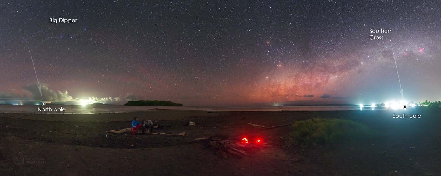
Explanation: Welcome to an equatorial night.
This remarkable 24 frame night skyscape was captured from Maba Beach on the Indonesian island of Halmahera during the evening of March 4. Seen from a mere 0.7 degrees northern latitude, both famous northern and southern asterisms and
navigational aids lie within the panoramic view. The Big Dipper is on the far left and Southern Cross at the far right. Beyond the fading campfire on that night a yellow-orange celestial triangle
is set by Mars, Antares, and Saturn. It stands above the rising central Milky Way, or "Miett" in the local Maba language. Of course, you can follow the
pole pointing stars in the cup of the Big Dipper or body of the
Southern Cross to the north and south celestial poles. Both lie just at the horizon in the view from the island's
equatorial beach.
[/b]
Re: APOD: Big Dipper to Southern Cross (2016 Mar 31)
Posted: Thu Mar 31, 2016 5:10 am
by Ann
I saw this image in the Observation Deck forum recently and liked it right away.
For me as a northerner, seeing the Big Dipper "upside down" is fascinating. And the serene, quite large, mostly blue Big Dipper, seen against a fairly "empty" (but skyglow-striped) hemisphere of the sky, makes for a enormous contrast to the busy, rich Milky Way rising in the other part of the sky. Personally I think that the reddish center of the Milky Way, crisscrossed with a multitude of dust lanes, makes it look as if the Milky Way was on fire and full of smoke.
What a fascinating image!

Ann
Re: APOD: Big Dipper to Southern Cross (2016 Mar 31)
Posted: Thu Mar 31, 2016 5:51 am
by Chris Peterson
Ann wrote:For me as a northerner, seeing the Big Dipper "upside down" is fascinating.
Of course, it's the same "upside down" orientation for you, in Malmö on that date, as it is in Indonesia. It's just a lot higher in the sky (nearly the zenith), so you may not make the same association with the horizon.
Re: APOD: Big Dipper to Southern Cross (2016 Mar 31)
Posted: Thu Mar 31, 2016 6:09 am
by RocketRon
Marvellous photo, just magic.
A great viewing location helps...
The drawing overlay pointing to the south pole isn't drawn quite correctly though. ?
The line through the long axis of the southern cross has to be intersected with a line drawn through the 2 pointers (2 bright stars in close proximity),
and a line then drawn down perpendicularly to the horizon to give a close approximation of the direction of the south pole.
There may not be much difference with the sthn cross so close to the horizon as in the pic here,
but with the nighly rotation of the stars, (the earths rotation, obviously) and at higher latitudes,
the sthn cross can be quite high in the sky.
And without the intersection of the line drawn through the 2 pointers, would only very vaguely point towards the south pole at all.
Re: APOD: Big Dipper to Southern Cross (2016 Mar 31)
Posted: Thu Mar 31, 2016 6:45 am
by Nitpicker
RocketRon wrote:Marvellous photo, just magic.
A great viewing location helps...
The drawing overlay pointing to the south pole isn't drawn quite correctly though. ?
The line through the long axis of the southern cross has to be intersected with a line drawn through the 2 pointers (2 bright stars in close proximity),
and a line then drawn down perpendicularly to the horizon to give a close approximation of the direction of the south pole.
There may not be much difference with the sthn cross so close to the horizon as in the pic here,
but with the nighly rotation of the stars, (the earths rotation, obviously) and at higher latitudes,
the sthn cross can be quite high in the sky.
And without the intersection of the line drawn through the 2 pointers, would only very vaguely point towards the south pole at all.
That's not quite right Ron. The intersection point (of Crux's long axis and the Pointers' bisector) is a close approximation to the South Celestial Pole (within about 3 degrees). From this point, a line dropped vertically to the horizon gives you a pretty good southward bearing on Earth. But from the Equator, the intersection point is very close to the horizon.
Re: APOD: Big Dipper to Southern Cross (2016 Mar 31)
Posted: Thu Mar 31, 2016 12:39 pm
by neufer
Chris Peterson wrote:Ann wrote:
For me as a northerner, seeing the Big Dipper "upside down" is fascinating.
Of course, it's the same "upside down" orientation for you, in Malmö on that date, as it is in Indonesia. It's just a lot higher in the sky (nearly the zenith), so you may not make the same association with the horizon.
Well, then, it's NOT the same "upside down" orientation for Ann, in Malmö on that date.
Re: APOD: Big Dipper to Southern Cross (2016 Mar 31)
Posted: Thu Mar 31, 2016 1:35 pm
by heehaw
We all get so set in our ways that we think our thoughts and prejudices are universal truths. To help overcome this, every classroom in the northern hemisphere should have up on the wall not one, but two copies of McArthur's Universal Corrective Map of the World. The second copy should be at ninety degrees to this image, and is precisely as accurate a picture of our globe:
https://de.wikipedia.org/wiki/McArthur’ ... _the_World
Ja? Nein? Warum?
Re: APOD: Big Dipper to Southern Cross (2016 Mar 31)
Posted: Thu Mar 31, 2016 2:06 pm
by Chris Peterson
neufer wrote:Chris Peterson wrote:Ann wrote:
For me as a northerner, seeing the Big Dipper "upside down" is fascinating.
Of course, it's the same "upside down" orientation for you, in Malmö on that date, as it is in Indonesia. It's just a lot higher in the sky (nearly the zenith), so you may not make the same association with the horizon.
Well, then, it's NOT the same "upside down" orientation for Ann, in Malmö on that date.
I'd define the orientation by the angle with respect to the horizon, not the height above the horizon. (I did not suggest that Ann had an identical view, of course... and I expect that it was the combination of angle and distance from the horizon she was talking about.)
For people living at moderate to high northern latitudes, the Big Dipper is circumpolar, and can be observed at all possible orientations (there are American Indian tales that involve the bear being on its back part of the year). It is people further south who get a more limited view, never seeing the Dipper "right side up".
Re: APOD: Big Dipper to Southern Cross (2016 Mar 31)
Posted: Thu Mar 31, 2016 2:13 pm
by Chris Peterson
heehaw wrote:We all get so set in our ways that we think our thoughts and prejudices are universal truths. To help overcome this, every classroom in the northern hemisphere should have up on the wall not one, but two copies of McArthur's Universal Corrective Map of the World. The second copy should be at ninety degrees to this image, and is precisely as accurate a picture of our globe:
https://de.wikipedia.org/wiki/McArthur’ ... _the_World
Ja? Nein? Warum?
Nein.
We have conventions for a reason: to facilitate communication. Using maps with non-standard orientations in a
lesson is a very good idea, because it allows for the teaching of the idea of conventions, and the idea that some aspects of convention are arbitrary (but not all- a world map centered on Australia, for instance, would be silly). But outside the lesson, the maps hanging on the classroom wall should be conventional.
Re: APOD: Big Dipper to Southern Cross (2016 Mar 31)
Posted: Thu Mar 31, 2016 2:15 pm
by neufer
Chris Peterson wrote:
I'd define the orientation by the angle with respect to the horizon, not the height above the horizon. For people living at moderate to high northern latitudes, the Big Dipper is circumpolar, and can be observed at all possible orientations.
- For people living at high northern latitudes, the Big Dipper is circumpolar,
and always right side up vis-a-vis the horizon.
Re: APOD: Big Dipper to Southern Cross (2016 Mar 31)
Posted: Thu Mar 31, 2016 2:42 pm
by Chris Peterson
neufer wrote:Chris Peterson wrote:
I'd define the orientation by the angle with respect to the horizon, not the height above the horizon. For people living at moderate to high northern latitudes, the Big Dipper is circumpolar, and can be observed at all possible orientations.
- For people living at high northern latitudes, the Big Dipper is circumpolar,
and always right side up vis-a-vis the horizon.
Yes. But at Ann's latitude, the Big Dipper is always in the northern sky (just clipping the zenith in March), and is therefore seen at all orientations (including a wide range of "upside down" ones). That's consistent with American Indians recognizing the asterism in both an upside down and a right side up orientation.
As noted, what was catching Ann's eye was that orientation so close to the horizon, not the orientation itself. We tend to see asterisms quite differently when they're high in the sky (as the Big Dipper usually is for Ann) than we do when they're lower. For Ann, the most comfortable viewing of the Big Dipper is when it's below Polaris- "right side up" from her perspective. Like most of us living in the north, she has a bias that north is somewhere above the northern horizon. It throws our intuition off-balance when north is
below the northern horizon, which is why images like this can look somewhat startling (or at least, very unusual).
Re: APOD: Big Dipper to Southern Cross (2016 Mar 31)
Posted: Thu Mar 31, 2016 5:31 pm
by rstevenson
heehaw wrote:We all get so set in our ways that we think our thoughts and prejudices are universal truths. To help overcome this, every classroom in the northern hemisphere should have up on the wall not one, but two copies of McArthur's Universal Corrective Map of the World. The second copy should be at ninety degrees to this image, and is precisely as accurate a picture of our globe:
https://de.wikipedia.org/wiki/McArthur’ ... _the_World
Ja? Nein? Warum?
I prefer the
Dymaxion Map, since it can be rearranged to show whatever self-centered view of the world you might wish.
Rob
Re: APOD: Big Dipper to Southern Cross (2016 Mar 31)
Posted: Thu Mar 31, 2016 6:33 pm
by heehaw
I prefer the
Dymaxion Map, since it can be rearranged to show whatever self-centered view of the world you might wish.
Rob[/quote]
Wow, thanks Rob, that is terrific! Never heard of it before!
Re: APOD: Big Dipper to Southern Cross (2016 Mar 31)
Posted: Thu Mar 31, 2016 6:40 pm
by ricky302
Chris Peterson wrote:As noted, what was catching Ann's eye was that orientation so close to the horizon, not the orientation itself.
Really? I can't see anything in her post referring to the orientation of the big dipper to the horizon?
Ann wrote:For me as a northerner, seeing the Big Dipper "upside down" is fascinating.
In fact I don't think it could be more plain as to what she is saying.
Re: APOD: Big Dipper to Southern Cross (2016 Mar 31)
Posted: Thu Mar 31, 2016 6:59 pm
by Chris Peterson
ricky302 wrote:Chris Peterson wrote:As noted, what was catching Ann's eye was that orientation so close to the horizon, not the orientation itself.
Really? I can't see anything in her post referring to the orientation of the big dipper to the horizon?
Ann wrote:For me as a northerner, seeing the Big Dipper "upside down" is fascinating.
In fact I don't think it could be more plain as to what she is saying.
Well, Ann can answer when she gets the chance. But it seems clear to me that she's not used to seeing the upside down dipper with an obvious horizon reference. Because she can see that same orientation simply by looking upwards while facing north.
Re: APOD: Big Dipper to Southern Cross (2016 Mar 31)
Posted: Thu Mar 31, 2016 8:14 pm
by Ann
Chris Peterson wrote:Ann wrote:For me as a northerner, seeing the Big Dipper "upside down" is fascinating.
Of course, it's the same "upside down" orientation for you, in Malmö on that date, as it is in Indonesia. It's just a lot higher in the sky (nearly the zenith), so you may not make the same association with the horizon.
I have to agree with you, Chris. After seeing the play "Jane Eyre" at a theater quite close to where I live, I looked at the unusually clear night sky on my way home and searched for the Big Dipper. It was so high in the sky that I almost had to bend over backwards to see it, but indeed, it was upside down.
It is quite uncomfortable to bend over so far to observe the sky, so I very rarely do it. I guess that is why, when I sort of casually watch the sky, I only spot the Big Dipper when it is "right side up". By that I mean, like Chris said, when it is below Polaris.
Ann
Re: APOD: Big Dipper to Southern Cross (2016 Mar 31)
Posted: Thu Mar 31, 2016 11:55 pm
by Boomer12k
Neat Image... just great...
Glad Ann got to see her play... now for the Opera...
:---[===] *
Re: APOD: Big Dipper to Southern Cross (2016 Mar 31)
Posted: Fri Apr 01, 2016 1:37 am
by Nitpicker
Chris Peterson wrote:We have conventions for a reason: to facilitate communication. Using maps with non-standard orientations in a lesson is a very good idea, because it allows for the teaching of the idea of conventions, and the idea that some aspects of convention are arbitrary (but not all- a world map centered on Australia, for instance, would be silly). But outside the lesson, the maps hanging on the classroom wall should be conventional.
Many of the (conventional, North up) world maps sold in Australia are centred on Australia, or the Pacific, or the date line. It makes sense for us on the East coast of Australia (and others on the Pacific rim). Some maps even show some overlap on the left and right edges, with each showing the UK.
I agree that South up is typically a silly convention these days. Historically (if you go back far enough) maps were often
oriented with
East up. And maps of port cities were often oriented with the port side at the bottom.
Re: APOD: Big Dipper to Southern Cross (2016 Mar 31)
Posted: Fri Apr 01, 2016 1:54 am
by Chris Peterson
Nitpicker wrote:Chris Peterson wrote:We have conventions for a reason: to facilitate communication. Using maps with non-standard orientations in a lesson is a very good idea, because it allows for the teaching of the idea of conventions, and the idea that some aspects of convention are arbitrary (but not all- a world map centered on Australia, for instance, would be silly). But outside the lesson, the maps hanging on the classroom wall should be conventional.
Many of the (conventional, North up) world maps sold in Australia are centred on Australia, or the Pacific, or the date line. It makes sense for us on the East coast of Australia (and others on the Pacific rim). Some maps even show some overlap on the left and right edges, with each showing the UK.
Certainly, if by "center" you mean centering the longitude on central Australia. I think a world map with any latitude other than the equator in the center is pretty silly, though.
Re: APOD: Big Dipper to Southern Cross (2016 Mar 31)
Posted: Fri Apr 01, 2016 2:25 am
by Nitpicker
Chris Peterson wrote:Certainly, if by "center" you mean centering the longitude on central Australia. I think a world map with any latitude other than the equator in the center is pretty silly, though.
Yes, I meant centred on a longitude. Though I'll note in passing that many world maps, dare I say a majority, are centred on a latitude that is North of the Equator. Many ignore the world South of South America.
Re: APOD: Big Dipper to Southern Cross (2016 Mar 31)
Posted: Fri Apr 01, 2016 5:21 pm
by DavidLeodis
It's a fascinating image

.
It would have been better (well at least for me

) if Mars, Saturn and Antares had been labelled on the annotated version as I am unsure which is which. In the image description in Petr's website it states "with bright „red“ planet Mars and a bit fainter Saturn close to the bright red star Antares". I take it therefore that as the lowest object seems to be the faintest then that is Saturn and so Antares will be that above and right of it, thus Mars is the topmost object of the 3. However the brightest object, which I would have thought would be Mars, is thus Antares. Was Antares visually brighter than Mars at least then? I would be grateful if someone could please state which are definitely Mars, Saturn and Antares.
The "navigational aids" link seems to be dead.
Re: APOD: Big Dipper to Southern Cross (2016 Mar 31)
Posted: Fri Apr 01, 2016 5:44 pm
by Ann
DavidLeodis wrote:It's a fascinating image
.
It would have been better (well at least for me
) if Mars, Saturn and Antares had been labelled on the annotated version as I am unsure which is which. In the image description in Petr's website it states "with bright „red“ planet Mars and a bit fainter Saturn close to the bright red star Antares". I take it therefore that as the lowest object seems to be the faintest then that is Saturn and so Antares will be that above and right of it, thus Mars is the topmost object of the 3. However the brightest object, which I would have thought would be Mars, is thus Antares. Was Antares visually brighter than Mars at least then? I would be grateful if someone could please state which are definitely Mars, Saturn and Antares.
The "navigational aids" link seems to be dead.
In the triangle you refer to, Mars is the topmost object, Antares is the middle one and Saturn is the lowest one, closest to the horizon.
As of today, according to my software, Mars is magnitude -0.6 and Antares is +1.06. That makes Mars one and a half magnitude brighter than Antares. But I have no idea how bright Mars was compared to Antares when this picture was taken.
Ann
Re: APOD: Big Dipper to Southern Cross (2016 Mar 31)
Posted: Fri Apr 01, 2016 7:44 pm
by DavidLeodis
Thank you Ann for your help which is appreciated
.
Re: APOD: Big Dipper to Southern Cross (2016 Mar 31)
Posted: Wed Apr 06, 2016 2:09 pm
by neufer
Nitpicker wrote:Chris Peterson wrote:
Certainly, if by "center" you mean centering the longitude on central Australia. I think a world map with any latitude other than the equator in the center is pretty silly, though.
Yes, I meant centred on a longitude. Though I'll note in passing that many world maps, dare I say a majority, are centred on a latitude that is North of the Equator. Many ignore the world South of South America.
Re: APOD: Big Dipper to Southern Cross (2016 Mar 31)
Posted: Wed Apr 06, 2016 2:19 pm
by Chris Peterson
Nitpicker wrote:Chris Peterson wrote:Certainly, if by "center" you mean centering the longitude on central Australia. I think a world map with any latitude other than the equator in the center is pretty silly, though.
Yes, I meant centred on a longitude. Though I'll note in passing that many world maps, dare I say a majority, are centred on a latitude that is North of the Equator. Many ignore the world South of South America.
People create all sorts of maps with odd projections, for all sorts of reasons. But I don't recall seeing any world maps that didn't have their latitude centered on the equator (and certainly no classroom maps). I did a quick blast through Google images of world maps, and didn't see any that were centered north of the equator. I think such maps are quite rare.