Page 1 of 1
APOD: Map of Total Solar Eclipse Path in... (2016 Aug 21)
Posted: Sun Aug 21, 2016 4:05 am
by APOD Robot
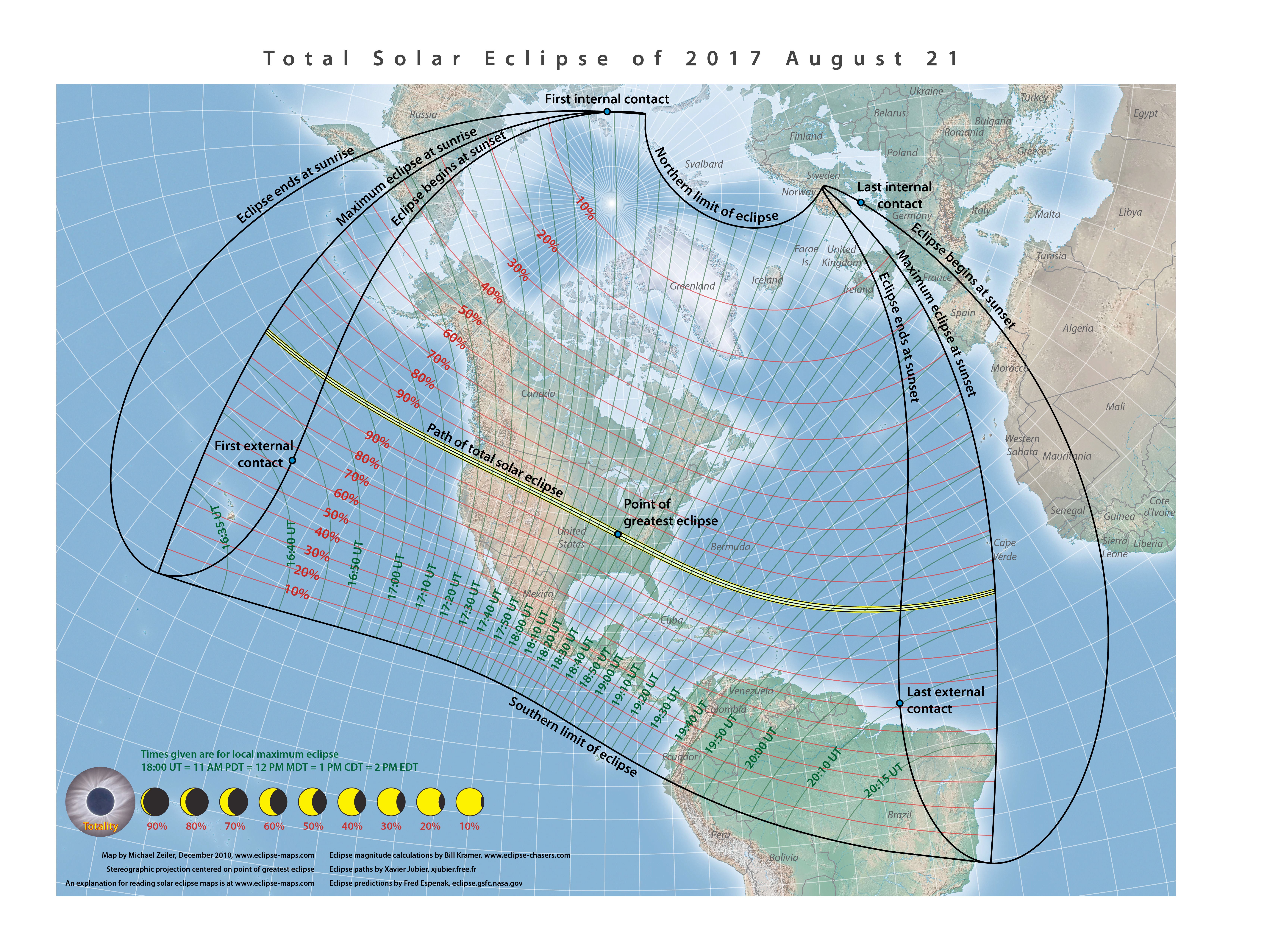
 Map of Total Solar Eclipse Path in 2017 August
Explanation:
Map of Total Solar Eclipse Path in 2017 August
Explanation: Would you like to see a total eclipse of the Sun? If so, do any friends or relatives live near the path of
next summer's eclipse? If yes again, then you might want to
arrange a visit for one year from today. Next year on this exact date, the path of a
total solar eclipse will
cut right across the center of the
contiguous USA.
All of
North America and part of
South America will experience, at the least, a
partial solar eclipse.
Featured here is a map of the path of totality, computed by eclipse expert
Fred Espenak of
NASA's
GSFC. Many people who have
seen a total solar eclipse
tell stories about it for the rest of their lives. The last
path of solar totality that included any part of the contiguous USA was in 1979, and the
next two will be in
2024 and
2045.
[/b]
Re: APOD: Map of Total Solar Eclipse Path in... (2016 Aug 21)
Posted: Sun Aug 21, 2016 9:00 am
by ezucker
The final sentence of today's text says: "The last path of solar totality that included any part of the contiguous USA was in 1979, and the next two will be in 2024 and 2045."
This is incorrect. Yes, the next one will be in 2024, but the one after that will be on August 23, 2044, followed the next year by a total solar eclipse on August 12, 2045.
http://eclipse.gsfc.nasa.gov/SEgoogle/S ... oogle.html
Evan Zucker
Totality Software, Inc.
San Diego, California
Re: APOD: Map of Total Solar Eclipse Path in... (2016 Aug 21)
Posted: Sun Aug 21, 2016 2:40 pm
by Jim Leff
I was a kid during the total eclipse of March 7, 1970, and remember it lasting over three minutes. I was taught at the time that "total" meant total. So how can this total eclipse be a minute shorter?
Re: APOD: Map of Total Solar Eclipse Path in... (2016 Aug 21)
Posted: Sun Aug 21, 2016 2:56 pm
by Chris Peterson
Jim Leff wrote:I was a kid during the total eclipse of March 7, 1970, and remember it lasting over three minutes. I was taught at the time that "total" meant total. So how can this total eclipse be a minute shorter?
The period of totality (along the center line) depends on many factors, such as where the Earth is in its orbit around the Sun (our orbit is not circular), where the Moon is in its around the Earth (also not circular), the angle the shadow line intersects the Earth's surface, and probably more. The geometry is complex.
At the simplest, just consider that that the distance from the Earth to the Moon changes, and therefore the apparent size of the Moon changes (there have been a number of APODs illustrating this). When the Moon appears larger, it will obscure the Sun for a longer time than when it appears smaller. When the Moon is at its farthest from us, it doesn't fully cover the Sun at all, and even a "total" eclipse won't be total, as in this annular "total" eclipse I shot through the clouds from San Diego in 1992.

Re: APOD: Map of Total Solar Eclipse Path in... (2016 Aug 21)
Posted: Sun Aug 21, 2016 5:07 pm
by RJN
ezucker wrote:
This is incorrect. Yes, the next one will be in 2024, but the one after that will be on August 23, 2044, followed the next year by a total solar eclipse on August 12, 2045.
Thanks, Evan. Fixed it. - RJN
Re: APOD: Map of Total Solar Eclipse Path in... (2016 Aug 21)
Posted: Sun Aug 21, 2016 8:31 pm
by ta152h0
Well within driving distance. Witnessed the last one in Goldendale, Washington 1978 i ELIEVE
Re: APOD: Map of Total Solar Eclipse Path in... (2016 Aug 21)
Posted: Sun Aug 21, 2016 8:39 pm
by Chris Peterson
ta152h0 wrote:Well within driving distance. Witnessed the last one in Goldendale, Washington 1978 i ELIEVE
I'll be at next year's, of course. But I'm hoping to hang in there for 2045, when the centerline passes just a few miles south of my house. Won't even need to leave the rocking chair on my deck.
Re: APOD: Map of Total Solar Eclipse Path in... (2016 Aug 21)
Posted: Sun Aug 21, 2016 9:10 pm
by Boomer12k
This will be my Second.... I live in Salem, Oregon... I will have a Ring Side Seat...I shall try to get you some good shots...
:---[===] *
Re: APOD: Map of Total Solar Eclipse Path in... (2016 Aug 21)
Posted: Sun Aug 21, 2016 9:45 pm
by slee
I live in Carbondale, IL, and Southern Illinois University is getting ready, the town is getting ready and the people are getting ready!

Re: APOD: Map of Total Solar Eclipse Path in... (2016 Aug 21)
Posted: Mon Aug 22, 2016 3:39 am
by alter-ego
For those who aren't aware of this, there's another good interactive site by Xavier Jubier found
here. You can search the eclipse data base and get interactive maps for most, if not all, of the Five Millenium Canon of Solar Eclipses.
Re: APOD: Map of Total Solar Eclipse Path in... (2016 Aug 21)
Posted: Mon Aug 22, 2016 3:02 pm
by Ctrl-Z
I assume the blue lines are the extent of moon's shadow, and maybe the yellow perpendicular lines are each passing hour... but which hours of the day will this be occurring? Some sort of map legend would be helpful.
Re: APOD: Map of Total Solar Eclipse Path in... (2016 Aug 21)
Posted: Mon Aug 22, 2016 6:46 pm
by BillBixby
Ctrl-Z wrote:I assume the blue lines are the extent of moon's shadow, and maybe the yellow perpendicular lines are each passing hour... but which hours of the day will this be occurring? Some sort of map legend would be helpful.
Click on the "featured here" link.
Re: APOD: Map of Total Solar Eclipse Path in... (2016 Aug 21)
Posted: Tue Feb 21, 2017 6:16 pm
by bystander
Megamovie Project to Crowdsource Images of August Solar Eclipse
http://asterisk.apod.com/viewtopic.php?t=36877