APOD: Curiosity Surveys Lower Mount Sharp... (2016 Dec 28)

Comments and questions about the APOD on the main view screen.
User avatar
APOD Robot
Otto Posterman
Posts: 5521
Joined: Fri Dec 04, 2009 3:27 am

APOD: Curiosity Surveys Lower Mount Sharp... (2016 Dec 28)

Post by APOD Robot » Wed Dec 28, 2016 8:56 am

Image Curiosity Surveys Lower Mount Sharp on Mars

Explanation: If you could stand on Mars -- what might you see? If you were the Curiosity rover, then just last month you would have contemplated the featured image -- a breathtaking panorama of the lower portion of Mount Sharp. The colors have been adjusted to mimic lighting familiar to Earthlings. Surveyed here was a rocky plain before increasingly high rolling hills. The rounded hills in the middle distance, called the Sulfate Unit, are Curiosity's highest currently planned destination. One reason these hills are interesting is because sulfates are an energy source for some micro-organisms. The immediate path forward, though, was toward the southeast on the left part of the image.

<< Previous APOD This Day in APOD Next APOD >>
[/b]

isblech@gmail.com

Re: APOD: Curiosity Surveys Lower Mount Sharp... (2016 Dec 28)

Post by isblech@gmail.com » Wed Dec 28, 2016 9:23 am

This is a fantastic picture of a river bed, the stones are as now washed !

jandomc

Re: APOD: Curiosity Surveys Lower Mount Sharp... (2016 Dec 28)

Post by jandomc » Wed Dec 28, 2016 10:16 am

To me it looks more like the shore of a lake - but same effect of water-deposited and shaped rocks and sandy bed

Guest

Re: APOD: Curiosity Surveys Lower Mount Sharp... (2016 Dec 28)

Post by Guest » Wed Dec 28, 2016 10:39 am

I don't see any sign of dust on the foreground surface, and it should be there. Esp in the 'wind shadow' of some of the rock structures.

heehaw

Re: APOD: Curiosity Surveys Lower Mount Sharp... (2016 Dec 28)

Post by heehaw » Wed Dec 28, 2016 10:45 am

Treasure, treasure, our watery Earth! I'll go out on a limb and say that no humans will EVER go to Mercury, or to Venus, or Jupiter, or Saturn, or Uranus, or Neptune, or Pluto! The only good news is that we humans HAVE gone to our own Moon. We could go to an asteroid or two, but why would we? That leaves dear Mars! But, no magnetic field to shield from cosmic rays! Live underground? Well, if you are going to live underground, why not do it in the Sahara desert and save some money? But, not to be an old grouch, I do like the idea of a permanent manned (and woman-ed) base on the Moon (with nuclear power) .... just because, like Everest, it is there!

CharlesE
Ensign
Posts: 11
Joined: Fri Nov 28, 2014 4:46 pm
Location: Southeastern Connecticut

Re: APOD: Curiosity Surveys Lower Mount Sharp... (2016 Dec 28)

Post by CharlesE » Wed Dec 28, 2016 11:24 am

Curiosity is definitely going to be doing some maneuvering over the next few weeks. Are those obstructions (boulders) typical of the Martian terrain? Most of the photos I've seen before were generally of cobblestone sized rocks with a few largers boulders in the image.

This looks very much like a silted in stream bed that has armored itself with boulders over time.

User avatar
neufer
Vacationer at Tralfamadore
Posts: 18805
Joined: Mon Jan 21, 2008 1:57 pm
Location: Alexandria, Virginia

Re: APOD: Curiosity Surveys Lower Mount Sharp... (2016 Dec 28)

Post by neufer » Wed Dec 28, 2016 1:03 pm

heehaw wrote:
The only good news is that we humans HAVE gone to our own Moon. We could go to an asteroid or two, but why would we? That leaves dear Mars! But, no magnetic field to shield from cosmic rays! Live underground? Well, if you are going to live underground, why not do it in the Sahara desert and save some money? But, not to be an old grouch, I do like the idea of a permanent manned (and woman-ed) base on the Moon (with nuclear power) .... just because, like Everest, it is there!
https://news.vice.com/article/one-year- ... nt-everest
Art Neuendorffer

User avatar
Cousin Ricky
Science Officer
Posts: 460
Joined: Mon Aug 26, 2013 4:08 pm
Location: St. Thomas, U.S. Virgin Islands (+18.3, -64.9)

Re: APOD: Curiosity Surveys Lower Mount Sharp... (2016 Dec 28)

Post by Cousin Ricky » Wed Dec 28, 2016 4:48 pm

The rock strata also scream “water.”

User avatar
rstevenson
Quis custodiet ipsos custodes?
Posts: 2705
Joined: Fri Mar 28, 2008 1:24 pm
Location: Halifax, NS, Canada

Re: APOD: Curiosity Surveys Lower Mount Sharp... (2016 Dec 28)

Post by rstevenson » Wed Dec 28, 2016 8:52 pm

Guest wrote:I don't see any sign of dust on the foreground surface, and it should be there. Esp in the 'wind shadow' of some of the rock structures.
The charcoal gray material is the dust, a lot of which is more like sand than dust. Here's a crop of an area near the bottom-left. I've increased the contrast a bit to enhance the variations in the dark dusty area.
rock close-up.jpg
Rob
You do not have the required permissions to view the files attached to this post.

User avatar
rstevenson
Quis custodiet ipsos custodes?
Posts: 2705
Joined: Fri Mar 28, 2008 1:24 pm
Location: Halifax, NS, Canada

Re: APOD: Curiosity Surveys Lower Mount Sharp... (2016 Dec 28)

Post by rstevenson » Wed Dec 28, 2016 8:57 pm

heehaw wrote:... I'll go out on a limb and say that no humans will EVER go to Mercury, or to Venus, or Jupiter, or Saturn, or Uranus, or Neptune, or Pluto! ... We could go to an asteroid or two, but why would we? ...
Depends on what you mean by "go to". Assuming we don't kill ourselves off before getting the chance, I expect in about a century or so we'll begin to buzz busily about the Solar System, visiting everywhere we can land and some things we can't land on. And that includes asteroids, which we may begin to mine for various resources. As for living on Mars, it will be very difficult, but there's no doubt that people with motivation will do it. Human beans are a bit crazy that way.

Rob

User avatar
rstevenson
Quis custodiet ipsos custodes?
Posts: 2705
Joined: Fri Mar 28, 2008 1:24 pm
Location: Halifax, NS, Canada

Re: APOD: Curiosity Surveys Lower Mount Sharp... (2016 Dec 28)

Post by rstevenson » Wed Dec 28, 2016 9:03 pm

CharlesE wrote:Curiosity is definitely going to be doing some maneuvering over the next few weeks. Are those obstructions (boulders) typical of the Martian terrain? ...
I believe the plan is to go around these particular boulders. It looks too rough to attempt going over. t's probably not a very large patch anyway.
CharlesE wrote:This looks very much like a silted in stream bed that has armored itself with boulders over time.
Before trying to guess at the history of these boulders, or any other landforms that Curiosity sees, recall that the rover is in a crater, trying to work its way up the mound (aka Mount Sharp) in the center of said crater. These partcular rocks were well under the Martian surface for a long time until that asteroid (or whatever) blasted this huge crater in the surface of Mars. The rock was probably laid down in a wet period early in Mars' history, and may have experienced some water erosion after the impact that exposed them, but it's been dry there for a very long time. Most of the weathering they exhibit has been caused by wind-blown sand and dust.

Rob

User avatar
Chris Peterson
Abominable Snowman
Posts: 18495
Joined: Wed Jan 31, 2007 11:13 pm
Location: Guffey, Colorado, USA

Re: APOD: Curiosity Surveys Lower Mount Sharp... (2016 Dec 28)

Post by Chris Peterson » Wed Dec 28, 2016 11:38 pm

rstevenson wrote:
Guest wrote:I don't see any sign of dust on the foreground surface, and it should be there. Esp in the 'wind shadow' of some of the rock structures.
The charcoal gray material is the dust, a lot of which is more like sand than dust.
I'd go with "regolith", which properly includes dust, sand, small rock fragments, and generally all the stuff we see dispersed around the large rocks here.
Chris

*****************************************
Chris L Peterson
Cloudbait Observatory
https://www.cloudbait.com

Zuben L. Genubi

Re: APOD: Curiosity Surveys Lower Mount Sharp... (2016 Dec 28)

Post by Zuben L. Genubi » Thu Dec 29, 2016 1:24 am

So, what's the business with the triangles?

User avatar
Chris Peterson
Abominable Snowman
Posts: 18495
Joined: Wed Jan 31, 2007 11:13 pm
Location: Guffey, Colorado, USA

Re: APOD: Curiosity Surveys Lower Mount Sharp... (2016 Dec 28)

Post by Chris Peterson » Thu Dec 29, 2016 1:40 am

Zuben L. Genubi wrote:So, what's the business with the triangles?
They're just scale markers. A little odd to use a triangle rather than a square, but they get the message across.
Chris

*****************************************
Chris L Peterson
Cloudbait Observatory
https://www.cloudbait.com

CharlesE
Ensign
Posts: 11
Joined: Fri Nov 28, 2014 4:46 pm
Location: Southeastern Connecticut

Re: APOD: Curiosity Surveys Lower Mount Sharp... (2016 Dec 28)

Post by CharlesE » Thu Dec 29, 2016 1:46 am

Mr. Stevenson:
Not arguing, just trying to relate what the image shows to similar earth land forms.

My experience is that stream beds often show large boulders in their bed, simply because erosive forces can move anything smaller. Either wind or water (or anything else that is flowing) could be the cause of the erosion. I suspect the boulders were left behind after smaller particles moved away. The boulders don't appear to my eye to be laid down, as debris from the asteroid collision. I would expect collison debris to be spread at random and to be oriented in different directions. In general, the boulders are oriented in similar directions and generally form a somewhat planar surface.

My recollection (and I'm an earth bound civil engineer - not a planetary meteorologist) is that martian winds are quite fast, but that the atmospheric pressure is considerably lower than on earth. Would boulders of the size seen in this image be moved by wind forces? Again, I have nothing to judge the size of those boulders by, but they are definitely considerably larger than the surrounding "earth" materials.

User avatar
rstevenson
Quis custodiet ipsos custodes?
Posts: 2705
Joined: Fri Mar 28, 2008 1:24 pm
Location: Halifax, NS, Canada

Re: APOD: Curiosity Surveys Lower Mount Sharp... (2016 Dec 28)

Post by rstevenson » Thu Dec 29, 2016 2:49 am

CharlesE wrote:... I suspect the boulders were left behind after smaller particles moved away. The boulders don't appear to my eye to be laid down, as debris from the asteroid collision. I would expect collison debris to be spread at random and to be oriented in different directions. In general, the boulders are oriented in similar directions and generally form a somewhat planar surface.
...
Sorry, I didn't mean to leave you with the impression they were blown around by the crater making impact. Rather these rock layers are more or less where they originally formed. They were cracked during the crater-making impact and subsequent rebound of the surface, then the forces of erosion took over. Some of this erosion would have occurred around the edges of each rock chunk because the wind (or water) would have sped up there. Undercutting of the chunks can occur when the erosion process encounters a softer material under a harder layer, and can eventualy lead to some of the chunks being undercut so much that they tip over in relation to the general flattish layer, but most will remain roughly aligned with each other, as we can see in this picture. Also, softer layers on top would eventually be removed entirely by the erosion, becoming part of the sand and dust. I don't know if we can tell how much material has been removed from above these rocks and blown away, but it is likely a significant amount. After all, Gale Crater is about 3.5 million years old. There's been plenty of time for a lot of erosion, however slowly it may occur.

Rob

User avatar
Chris Peterson
Abominable Snowman
Posts: 18495
Joined: Wed Jan 31, 2007 11:13 pm
Location: Guffey, Colorado, USA

Re: APOD: Curiosity Surveys Lower Mount Sharp... (2016 Dec 28)

Post by Chris Peterson » Thu Dec 29, 2016 5:23 am

rstevenson wrote:
CharlesE wrote:... I suspect the boulders were left behind after smaller particles moved away. The boulders don't appear to my eye to be laid down, as debris from the asteroid collision. I would expect collison debris to be spread at random and to be oriented in different directions. In general, the boulders are oriented in similar directions and generally form a somewhat planar surface.
...
Sorry, I didn't mean to leave you with the impression they were blown around by the crater making impact. Rather these rock layers are more or less where they originally formed. They were cracked during the crater-making impact and subsequent rebound of the surface, then the forces of erosion took over. Some of this erosion would have occurred around the edges of each rock chunk because the wind (or water) would have sped up there. Undercutting of the chunks can occur when the erosion process encounters a softer material under a harder layer, and can eventualy lead to some of the chunks being undercut so much that they tip over in relation to the general flattish layer, but most will remain roughly aligned with each other, as we can see in this picture. Also, softer layers on top would eventually be removed entirely by the erosion, becoming part of the sand and dust. I don't know if we can tell how much material has been removed from above these rocks and blown away, but it is likely a significant amount. After all, Gale Crater is about 3.5 million years old. There's been plenty of time for a lot of erosion, however slowly it may occur.
Gale Crater is a late Noachian or early Hesperian impact, which means it occurred while Mars still had extensive liquid water and a much denser atmosphere. It was subsequently built up, perhaps completely filled in, by wind and water supplied sediments, which were then eroded by water and possibly wind. So in all likelihood, we're seeing nothing here of the original material that was exposed by the impact, but rather, newer (although still old) deposits.
Chris

*****************************************
Chris L Peterson
Cloudbait Observatory
https://www.cloudbait.com

User avatar
Ann
4725 Å
Posts: 13714
Joined: Sat May 29, 2010 5:33 am

Re: APOD: Curiosity Surveys Lower Mount Sharp... (2016 Dec 28)

Post by Ann » Thu Dec 29, 2016 5:30 am

As a complete, total geology amateur (not in the same way that I am an astronomy amateur, because I do know something about astronomy, after all) - well, as a complete, total amateur when it comes to geology, I think the appearance of the Mars-scape in the APOD suggests that the rocks may have been moved around and deposited by water or ice.
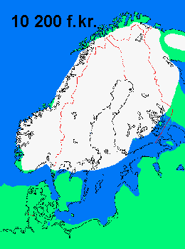
Image
Ice sheet covering much of Scandinavia in 10200 B.C.
http://www.tacitus.nu/historisk-atlas/s ... stiden.htm.
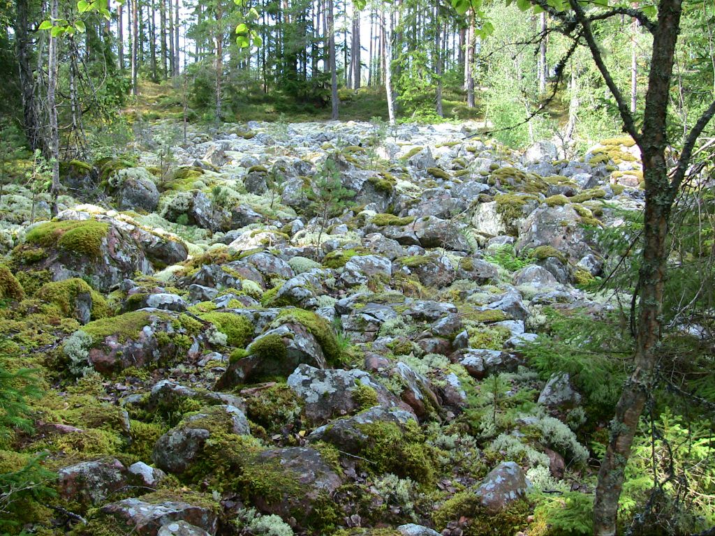
Landscape left behind by the retreating ice sheet.
Source: http://www.trehorna.nu/sevart-runt-trehorna


Since I live in Sweden, I am very much aware that my own country has been completely covered by ice for an extremely long time.

When the ice retreated, it left behind a landscape of rubble, where huge boulders had been moved around and broken into smaller pieces.

I can't help thinking that the broken boulders on Mars look a lot like the rubble that was left behind by the retreating ice in Sweden. Minus the moss, of course.

Ann
Color Commentator

User avatar
neufer
Vacationer at Tralfamadore
Posts: 18805
Joined: Mon Jan 21, 2008 1:57 pm
Location: Alexandria, Virginia

Re: APOD: Curiosity Surveys Lower Mount Sharp... (2016 Dec 28)

Post by neufer » Thu Dec 29, 2016 5:16 pm

Ann wrote:
As a complete, total geology amateur (not in the same way that I am an astronomy amateur, because I do know something about astronomy, after all) - well, as a complete, total amateur when it comes to geology, I think the appearance of the Mars-scape in the APOD suggests that the rocks may have been moved around and deposited by water or ice. Since I live in Sweden, I am very much aware that my own country has been completely covered by ice for an extremely long time. When the ice retreated, it left behind a landscape of rubble, where huge boulders had been moved around and broken into smaller pieces. I can't help thinking that the broken boulders on Mars look a lot like the rubble that was left behind by the retreating ice in Sweden. Minus the moss, of course.
Where are the U-shaped valleys, or glacial troughs, and those other things formed by the process of glaciation :?:

<<Slartibartfast is a designer of planets. His favourite part of the job is creating the fjords [i.e., former U-shaped valleys] for which he won an award. While trapped on prehistoric Earth, Arthur Dent and Ford Prefect see Slartibartfast's signature deep inside a glacier in ancient Norway.>>
Art Neuendorffer

CharlesE
Ensign
Posts: 11
Joined: Fri Nov 28, 2014 4:46 pm
Location: Southeastern Connecticut

Re: APOD: Curiosity Surveys Lower Mount Sharp... (2016 Dec 28)

Post by CharlesE » Thu Dec 29, 2016 5:31 pm

Ann: You're correct (my opinion) that the images you've shown are the result of glaciation processes.

The images Curiosity sent back appear to me to be the result of erosion of finer grained materials that were transported out of the picture by water or wind. That erosion leaves the larger material (boulders) in place, reducing the likelihood of further erosion of the erosion site. Simply put, the boulders are too dense to be moved by the wind or water. When closely spaced, the boulders also tend to act as wind or water breaks to reduce the erosive force on the remaining finer grained materials. Think of standing next to a large building during a windstorm, which can reduce the winds next to the building.

User avatar
Ann
4725 Å
Posts: 13714
Joined: Sat May 29, 2010 5:33 am

Re: APOD: Curiosity Surveys Lower Mount Sharp... (2016 Dec 28)

Post by Ann » Thu Dec 29, 2016 5:57 pm

neufer wrote:
Ann wrote:
As a complete, total geology amateur (not in the same way that I am an astronomy amateur, because I do know something about astronomy, after all) - well, as a complete, total amateur when it comes to geology, I think the appearance of the Mars-scape in the APOD suggests that the rocks may have been moved around and deposited by water or ice. Since I live in Sweden, I am very much aware that my own country has been completely covered by ice for an extremely long time. When the ice retreated, it left behind a landscape of rubble, where huge boulders had been moved around and broken into smaller pieces. I can't help thinking that the broken boulders on Mars look a lot like the rubble that was left behind by the retreating ice in Sweden. Minus the moss, of course.
Where are the U-shaped valleys, or glacial troughs, and those other things formed by the process of glaciation :?:

<<Slartibartfast is a designer of planets. His favourite part of the job is creating the fjords [i.e., former U-shaped valleys] for which he won an award. While trapped on prehistoric Earth, Arthur Dent and Ford Prefect see Slartibartfast's signature deep inside a glacier in ancient Norway.>>
You mean this?

Ann
Color Commentator

User avatar
neufer
Vacationer at Tralfamadore
Posts: 18805
Joined: Mon Jan 21, 2008 1:57 pm
Location: Alexandria, Virginia

Re: APOD: Curiosity Surveys Lower Mount Sharp... (2016 Dec 28)

Post by neufer » Thu Dec 29, 2016 6:23 pm

Ann wrote:
You mean this?
  • I mean that on Mars.
Art Neuendorffer